17
$\begingroup$

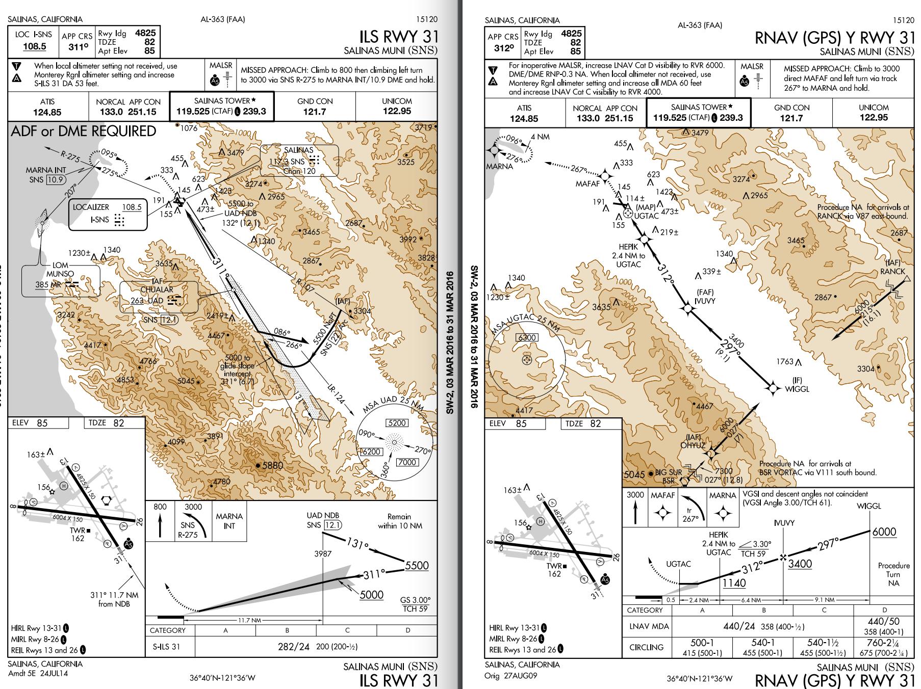
Tom is flying a C172S/G on ILS RWY 31 approach to KSNS. He just established on the localizer at 6000, from the SNS-22 DME Arc. He obtained weather from ATIS, wind 240@20G23, ceiling OVC006, visibility 1 1/2 SM. The wind favors RWY 26 but he notice there is no published circling minimum associated with his current ILS RWY 31 approach. He checked other approaches and found RNAV (GPS) Y RWY 31 @ KSNS has a published circling minimum of 500-1. He thinks since the two approaches are for the same runway and final leg should be similar, he may use the RNAV 500-1 circling minimum and to land on RWY 26.

X-Wind quick notes:

  • Wind angle for RWY 31 is 70˚.
  • Crosswind component for Landing on RWY 31 (18~22 knots)
  • Maximum demonstrated crosswind for C172S is 15 knots

In this case, what should he do?

  • A) Continue the ILS RWY 31 straight-in approach and land on RWY 31
  • B) Advise tower circle south to land on RWY 26. Start to circle upon reaching 500.
  • C) Change to RNAV (GPS) Y RWY 31 @ KSNS (approach without vertical guidance), re-intercept final approach course (WIGGL-IVUVY leg) and circling to RWY 26.
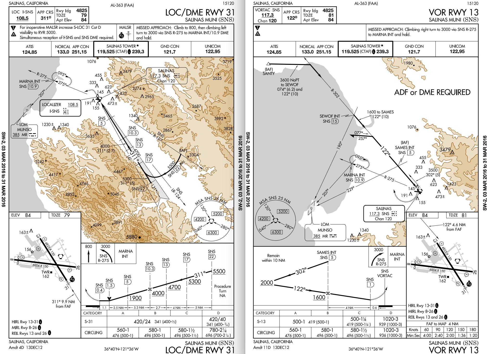
  • C*) Change to LOC/DME RWY 31 @KSNS (load a new approach) and circle at 560 to RWY 26
  • D) Once he has the airport in sight, cancel IFR and advise tower enter left base for RWY 26
  • E) Low-approach flying over RWY 31 until reaching 31-26 intersection, turn left and land on RWY 26.
  • F) Others, your suggestions. enter image description here enter image description here
$\endgroup$
4
  • 7
    $\begingroup$ A C172 can certainly land in a 20 kt crosswind, even though Cessna never demonstrated it. $\endgroup$
    – J W
    Commented Mar 28, 2016 at 9:54
  • 4
    $\begingroup$ That is a well asked question! $\endgroup$
    – FreeMan
    Commented Mar 28, 2016 at 13:31
  • $\begingroup$ This looks....startling like a homework question. Is it? $\endgroup$
    – Jae Carr
    Commented Mar 29, 2016 at 18:10
  • 1
    $\begingroup$ @JayCarr, this comes from an actual flight, except the actual ceiling is a little higher than described. $\endgroup$ Commented Mar 30, 2016 at 7:25

4 Answers 4

17
$\begingroup$

The only minimums that apply to any approach are those printed on the plate. Doing anything else is being a test pilot. Minimums are charted based on obstacle clearance, descent gradient, distance from the airport, and a variety of other factors.

The appropriate course of action is to either:

  • land straight in on 31 and attempt to deal with the crosswind. This would be preferred, in my opinion.
  • go missed and pick up the GPS Y 31 approach and circle to 25. You can't switch approaches once you're cleared. Given the ~1 mile visibility and low ceilings, this would not be ideal.
  • divert to your alternate if neither of those works.

Choosing a build-your-own circle with 600' ceilings is reckless - certainly more so than landing with a ~15-20 knot crosswind. There's no guarantee that you'll remain clear of any surface obstacles.

$\endgroup$
6
  • 1
    $\begingroup$ @JonathanWalters If it's really OVC006 you couldn't maintain VFR minimum cloud separation safely, but you could ask for an SVFR clearance. I'm not saying that would be a good idea, but the reported weather would allow it. $\endgroup$
    – Pondlife
    Commented Mar 28, 2016 at 12:42
  • 1
    $\begingroup$ Also, can the pilot in question not fly the LOC/DME approach to 31? Being at 6000 coming off the DME arc on the ILS onto the localizer puts you in the unenviable position of intercepting the glideslope from above...which is worthy of a "go back to square one and try this again" anyway as long as ATC doesn't have other ideas. $\endgroup$ Commented Mar 28, 2016 at 22:14
  • 2
    $\begingroup$ No matter what you do, if you choose a new named approach you need to start over. $\endgroup$
    – egid
    Commented Mar 29, 2016 at 4:05
  • 1
    $\begingroup$ I wouldn't call them a test pilot... More of an intrepid explorer who hopefully gets lucky and finds an unobstructed path through the mountains. $\endgroup$
    – Lnafziger
    Commented Mar 29, 2016 at 21:18
  • $\begingroup$ @Lnafziger how does 'wreckage' work? $\endgroup$
    – egid
    Commented Mar 29, 2016 at 22:03
9
$\begingroup$

Intro

This is a bit of an odd situation, but they have a good reason for doing what they did.

First of all, each instrument approach is designed to be a stand-alone procedure, and the designers consider that you may not have any of the other approach plates when you are flying a particular procedure. All of the information that you need to fly the approach is included on its individual chart.

Procedure differences

Now, let's look at the ILS and LOC approaches more closely with that in mind. Very often, these two approaches will be combined into one procedure. This has a benefit in that if the glideslope fails, you can simply descend to LOC minimums and continue the approach without having to go missed. In this case though, they are two different procedures. Why?

Equipment requirements:

  • The ILS RWY 31 approach requires an ILS receiver, plus ADF or DME (per the note, and is needed to identify the holding point).
  • The LOC/DME RWY 31 approach requires the LOC receiver and DME.

The designers wanted someone without DME to be able to fly the ILS procedure. Because of this, the missed approach point is only identified by reaching the decision height (282' MSL in this case) while on the glideslope. If you leveled off sooner, using only the equipment that is required to fly the approach, you have no way to identify the missed approach point (or the visual descent point for that matter). When you reached your self-imposed MDA, you would level off and continue to fly until the MAP if you don't break out. Wherever that may be.... This is why there are no circling minimums.

The LOC/DME procedure on the other hand requires DME, and specifies that the MAP is at 0.4 DME. Now you can descend to the specified minimums and continue along with no visual references until you reach the defined MAP, at which point you would fly the published missed approach procedure. If you are at the MDA and see the airport earlier, then you can circle in accordance with circling procedures if you have been cleared to do so.

The other two procedures require GPS or a VOR receiver, and define the MAP according to the required equipment, so also have circling minimums.

Resolution

Now that we know why they did this, what can we do differently? Plan ahead. You should know the weather before you are given an approach (via preflight planning and the ATIS). You should know which approaches are available and which one that you want to fly before ATC assigns it. If the ATIS states that they are using the ILS RWY 31 approach and you know that you want to land on a different runway, request the specific procedure and runway that you want on initial contact with approach.

As others have said, don't switch procedures in the middle of an approach. If you can't fly it, go missed and get properly setup / familiar with the procedure and fly the procedure when you are prepared for it.

If you decide to continue with the current procedure, you either land straight in, go missed, or request a contact approach to your preferred runway if you break out in time (this option would most likely require prior coordination since there may be traffic following too closely for them to approve it). Do not cancel IFR, as this isn't legal without a 1,000 ft. ceiling, and pilots have been violated for that.

The mountains surrounding the area that you are flying in will not be forgiving if you try to get into a contest of wills or rush and make a mistake.

Lastly, make sure that whatever you decide to do has been coordinated with ATC and that they know what you want to do and give you a clearance to do so. For everybody's well-being, you don't want to surprise anyone by doing something unexpected.
$\endgroup$
5
$\begingroup$

In this scenario, you do in fact have two legal options -- although you must decide if they are safe.

First, you can cancel IFR when you break out on the approach and switch to SVFR (this was mentioned in a comment by @pondlife). You can even coordinate it in advance with the approach controller, and even specify that you intend to do this in the "NOTES" section of the IFR flight plan. Although its legal for airplanes, it is more typically a helicopter procedure, due to heli's lower IFR and SVFR minimums. The process would be to descend on the straight-in approach, and when you can satisfy SVFR requirements, cancel IFR and substitute SVFR. You can then complete the approach to your desired circling runway.

The second option you might have is a contact approach (see below), although I have never heard of anyone actually requesting one in real weather. With the contact approach, you would ask for vectors to the airport, preferably towards Runway 26, at the MVA. If you can see the ground during the vector, and believe you can satisfy the contact parameters, you then request a contact approach, and follow the procedures outlined below.

Both of these scenarios are fairly obscure precisely because they do not afford you the safety margins that a straight-in or even a circling approach does.


Contact Approaches

If conditions permit, pilots can request a contact approach, which is then authorized by the controller. A contact approach cannot be initiated by ATC. This procedure may be used instead of the published procedure to expedite arrival, as long as the airport has a SIAP the reported ground visibility is at least 1 SM, and pilots are able to remain clear of clouds with at least one statute mile flight visibility throughout the approach. Some advantages of a contact approach are that it usually requires less time than the published instrument procedure, it allows pilots to retain the IFR clearance, and provides separation from IFR and SVFR traffic. On the other hand, obstruction clearances and VFR traffic avoidance becomes the pilot’s responsibility. Unless otherwise restricted, the pilot may find it necessary to descend, climb, or fly a circuitous route to the airport to maintain cloud clearance or terrain/ obstruction clearance.

The main differences between a visual approach and a contact approach are: a pilot must request a contact approach, while a visual approach may be assigned by ATC or requested by the pilot; and a contact approach may be approved with 1 mile visibility if the flight can remain clear of clouds, while a visual approach requires the pilot to have the airport in sight, or a preceding aircraft to be followed, and the ceiling must be at least 1,000 feet AGL with at least 3 SM visibility.

Source: Instrument Procedures Handbook, Chapter 4 (Approaches). “Contact Approaches,” p. 4-58 (49 MB PDF)

$\endgroup$
6
  • 1
    $\begingroup$ Since he specified a 600' ceiling, cancelling IFR is actually not a legal option (1000' minimum ceiling is required). A contact approach is a legal option though. $\endgroup$
    – Lnafziger
    Commented Aug 21, 2016 at 21:00
  • $\begingroup$ Actually the ceiling is reported OVC006, but you break out at 1000, under Part 91 at least you can still cancel. $\endgroup$
    – rbp
    Commented Aug 25, 2016 at 17:03
  • $\begingroup$ Umm, his question doesn't specify that, but if you want to assume that the weather is markedly better than reported in order to support your answer, then I suppose that you can do that, but should add the caveat to your answer. ;-) $\endgroup$
    – Lnafziger
    Commented Aug 25, 2016 at 17:43
  • $\begingroup$ Well, he didn't "specif[y] a 600' ceiling". He transcribed the reported ceiling. I have been grounded at KJCK when the reported ceiling was OVC001, because of a low-lying fog layer that was barely 25ft thick, under clear blue skies. Under Part 91, you can descend to minimums in spite of the reported weather and take a peek. $\endgroup$
    – rbp
    Commented Aug 25, 2016 at 23:26
  • $\begingroup$ I'm not saying that it isn't possible. Simply that there was nothing in the question to indicate that it might be the case. I'm suggesting that if you don't want to mislead others who aren't as familiar with the rules, that you should say something along the lines of "you can try the approach, and if the weather conditions are better than reported and above VFR weather minimums, then you could cancel.... As it is now you simply say that it is legal to cancel IFR... $\endgroup$
    – Lnafziger
    Commented Aug 26, 2016 at 3:48
1
$\begingroup$

No. And it possibly would be very dangerous to attempt to do so. Approach procedures are designed the way they are based upon airspace surveys by the FAA. In general, if it was feasible to circle, the plate would be published with circling minimums and procedures. The lack there of generally indicates conflicts, be it obstacle and terrain clearances, air traffic, or other hazards which can imperil the approach.

$\endgroup$
2
  • $\begingroup$ This is most of the answer, you should add that once you break out below the ceiling you have the option to cancel IFR and circle to another runway with a VFR traffic pattern assuming adequate visibility. Other options are a contact approach or special VFR. But all of these use pilot visual avoidance of obstacles. $\endgroup$
    – Max Power
    Commented Sep 14, 2020 at 20:37
  • $\begingroup$ Circling is a fallback for most approach design, as you said if they don't have circling minima there is almost certainly good reason. Either several very high obstacles within the circling protected area or a problem with going missed. If it is only one obstacle it will say something like "no circling west of 13-31", if the obstacles are near the edges then you may have N/A for cat D but still have cat A circling. $\endgroup$
    – Max Power
    Commented Sep 14, 2020 at 20:37

You must log in to answer this question.

Not the answer you're looking for? Browse other questions tagged .