Updated title and tags
Link
Lnafziger
  • 59.2k
  • 39
  • 244
  • 424

Can I flycircle to a circlingdifferent runway if cleared for an instrument approach without associated circling minimums?

Add the other two IAPs
Source Link
CrepuscularV
  • 3.4k
  • 3
  • 25
  • 56

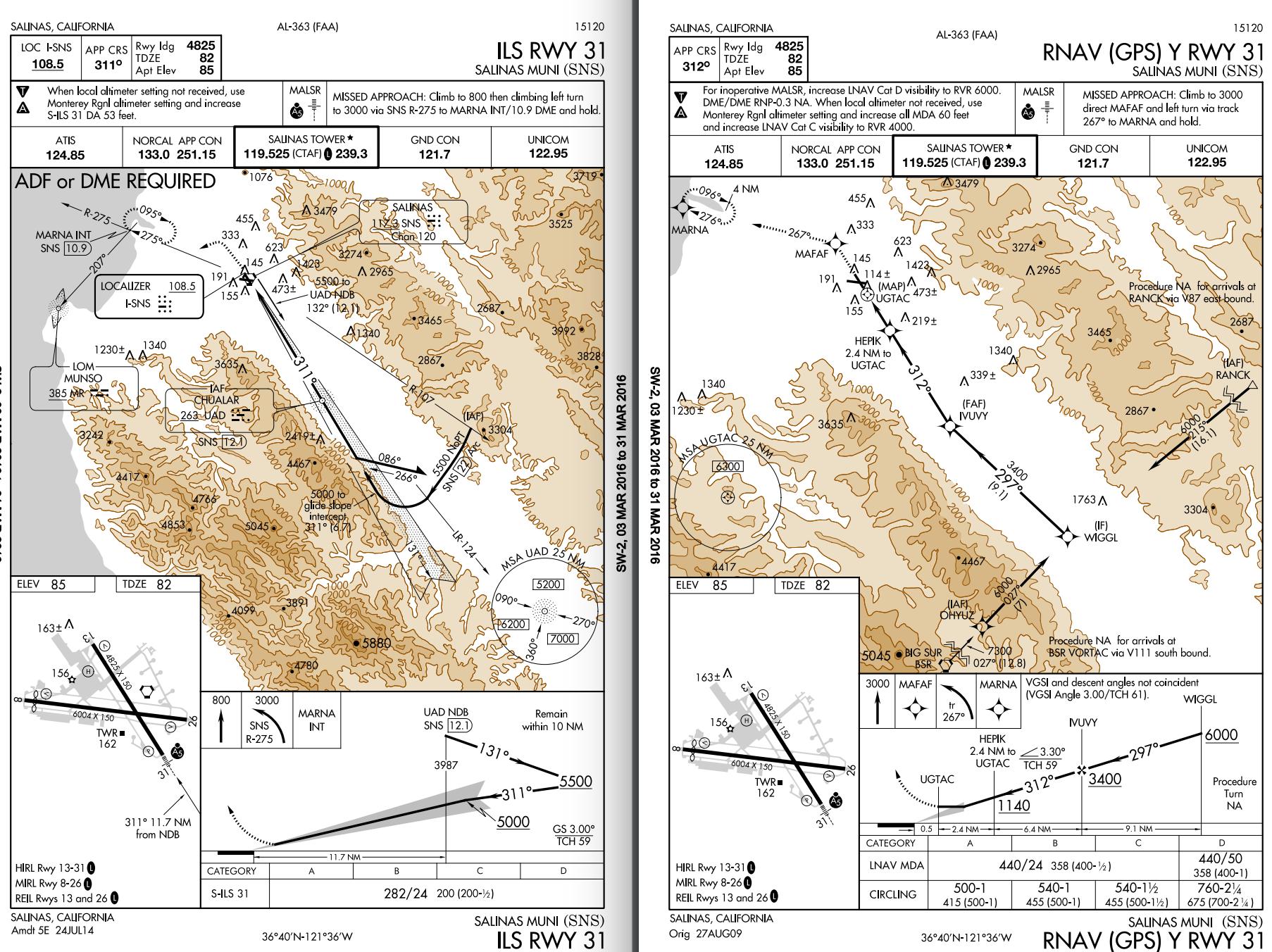
Tom is flying a C172S/G on ILS RWY 31 approach to KSNS. He just established on the localizer at 6000, from the SNS-22 DME Arc. He obtained weather from ATIS, wind 240@20G23, ceiling OVC006, visibility 1 1/2 SM. The wind favors RWY 26 but he notice there is no published circling minimum associated with his current ILS RWY 31 approach. He checked other approaches and found RNAV (GPS) Y RWY 31 @ KSNS has a published circling minimum of 500-1. He thinks since the two approaches are for the same runway and final leg should be similar, he may use the RNAV 500-1 circling minimum and to land on RWY 26.

X-Wind quick notes:

  • Wind angle for RWY 31 is 70˚.
  • Crosswind component for Landing on RWY 31 (18~22 knots)
  • Maximum demonstrated crosswind for C172S is 15 knots

In this case, what should he do?

  • A) Continue the ILS RWY 31 straight-in approach and land on RWY 31
  • B) Advise tower circle south to land on RWY 26. Start to circle upon reaching 500.
  • C) Change to RNAV (GPS) Y RWY 31 @ KSNS (approach without vertical guidance), re-intercept final approach course (WIGGL-IVUVY leg) and circling to RWY 26.
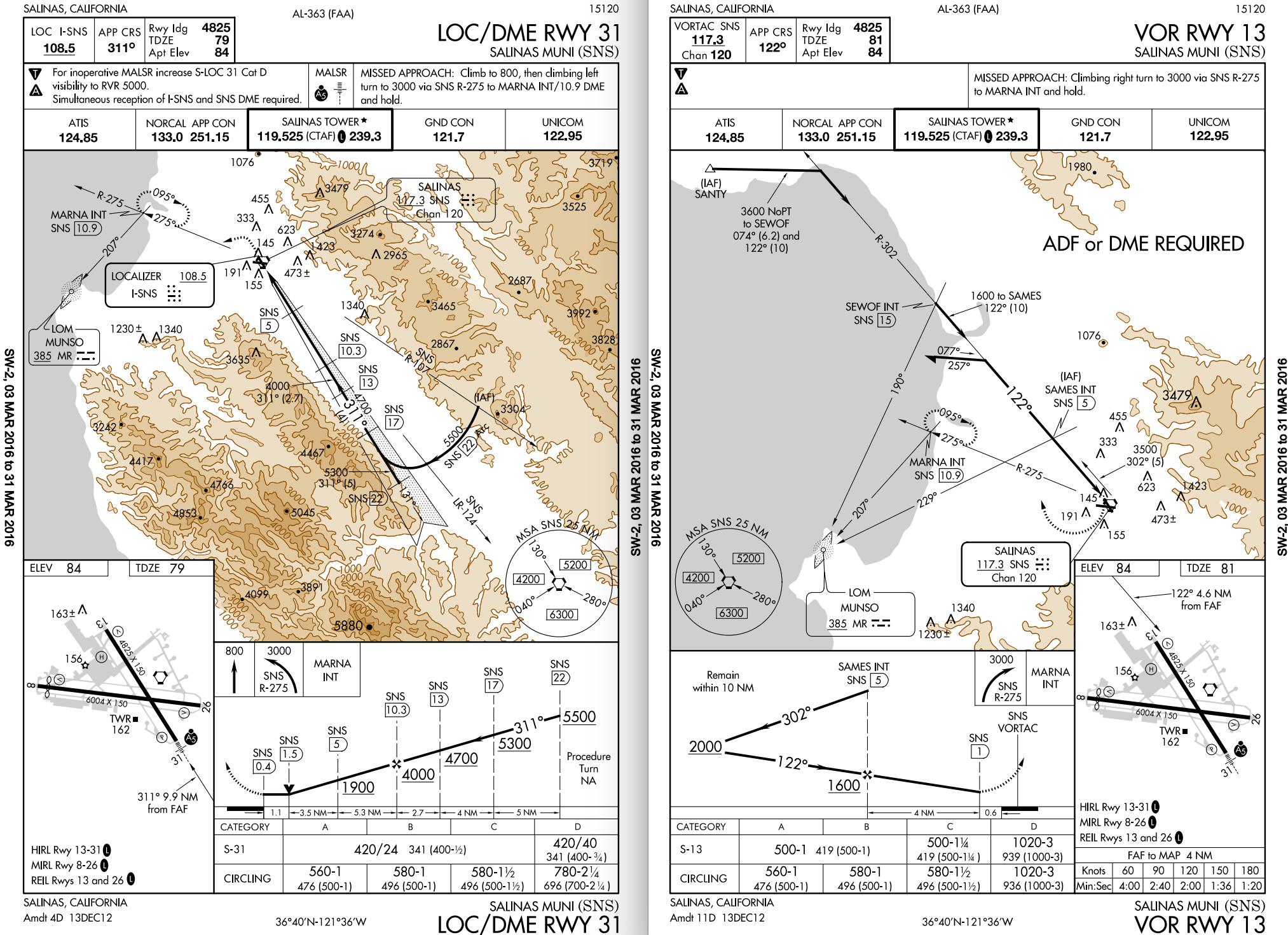
  • C*) Change to LOC/DME RWY 31 @KSNS (load a new approach) and circle at 560 to RWY 26
  • D) Once he has the airport in sight, cancel IFR and advise tower enter left base for RWY 26
  • E) Low-approach flying over RWY 31 until reaching 31-26 intersection, turn left and land on RWY 26.
  • F) Others, your suggestions. enter image description here enter image description here

Tom is flying a C172S/G on ILS RWY 31 approach to KSNS. He just established on the localizer at 6000, from the SNS-22 DME Arc. He obtained weather from ATIS, wind 240@20G23, ceiling OVC006, visibility 1 1/2 SM. The wind favors RWY 26 but he notice there is no published circling minimum associated with his current ILS RWY 31 approach. He checked other approaches and found RNAV (GPS) Y RWY 31 @ KSNS has a published circling minimum of 500-1. He thinks since the two approaches are for the same runway and final leg should be similar, he may use the RNAV 500-1 circling minimum and to land on RWY 26.

X-Wind quick notes:

  • Wind angle for RWY 31 is 70˚.
  • Crosswind component for Landing on RWY 31 (18~22 knots)
  • Maximum demonstrated crosswind for C172S is 15 knots

In this case, what should he do?

  • A) Continue the ILS RWY 31 straight-in approach and land on RWY 31
  • B) Advise tower circle south to land on RWY 26. Start to circle upon reaching 500.
  • C) Change to RNAV (GPS) Y RWY 31 @ KSNS (approach without vertical guidance), re-intercept final approach course (WIGGL-IVUVY leg) and circling to RWY 26.
  • D) Once he has the airport in sight, cancel IFR and advise tower enter left base for RWY 26
  • E) Low-approach flying over RWY 31 until reaching 31-26 intersection, turn left and land on RWY 26.
  • F) Others, your suggestions. enter image description here

Tom is flying a C172S/G on ILS RWY 31 approach to KSNS. He just established on the localizer at 6000, from the SNS-22 DME Arc. He obtained weather from ATIS, wind 240@20G23, ceiling OVC006, visibility 1 1/2 SM. The wind favors RWY 26 but he notice there is no published circling minimum associated with his current ILS RWY 31 approach. He checked other approaches and found RNAV (GPS) Y RWY 31 @ KSNS has a published circling minimum of 500-1. He thinks since the two approaches are for the same runway and final leg should be similar, he may use the RNAV 500-1 circling minimum and to land on RWY 26.

X-Wind quick notes:

  • Wind angle for RWY 31 is 70˚.
  • Crosswind component for Landing on RWY 31 (18~22 knots)
  • Maximum demonstrated crosswind for C172S is 15 knots

In this case, what should he do?

  • A) Continue the ILS RWY 31 straight-in approach and land on RWY 31
  • B) Advise tower circle south to land on RWY 26. Start to circle upon reaching 500.
  • C) Change to RNAV (GPS) Y RWY 31 @ KSNS (approach without vertical guidance), re-intercept final approach course (WIGGL-IVUVY leg) and circling to RWY 26.
  • C*) Change to LOC/DME RWY 31 @KSNS (load a new approach) and circle at 560 to RWY 26
  • D) Once he has the airport in sight, cancel IFR and advise tower enter left base for RWY 26
  • E) Low-approach flying over RWY 31 until reaching 31-26 intersection, turn left and land on RWY 26.
  • F) Others, your suggestions. enter image description here enter image description here
Tweeted twitter.com/StackAviation/status/714504850512416768
edited body; edited body
Source Link
CrepuscularV
  • 3.4k
  • 3
  • 25
  • 56

Tom is flying a C172S/G on ILS RWY 31 approach to KSNS. He just established on the localizer at 6000, from the SNS-22 DME Arc. He obtained weather from ATIS, wind 240@20G23, ceiling OVC006, visibility 1 1/2 SM. The wind favors RWY 26 but he notice there is no published circling minimum associated with his current ILS RWY 31 approach. He checked other approaches and found RNAV (GPS) Y RWY 31 @ KSNS has a published circling minimum of 500-1. He thinks since the two approaches are for the same runway and final leg should be similar, he may use the RNAV 500-1 circling minimum and to land on RWY 26.

X-Wind quick notes: Crosswind component for Landing on RWY 31 (18~22 knots). Demonstrated crosswind for C172S is 15 knots

  • Wind angle for RWY 31 is 70˚.
  • Crosswind component for Landing on RWY 31 (18~22 knots)
  • Maximum demonstrated crosswind for C172S is 15 knots

In this case, what should he do?

  • A) Continue the ILS RWY 31 straight-in approach and land on RWY 31
  • B) Advise tower circle south to land on RWY 26. Start to circle upon reaching 500.
  • C) Change to RNAV (GPS) Y RWY 31 @ KSNS (approach without vertical guidance), re-intercept final approach course (WIGGL-IVUVY leg) and circling to RWY 26.
  • D) Once he has the airport in sight, cancel IFR and advise tower enter left base for RWY 26
  • E) Low-approach flying over RWY 31 until reaching 31-26 intersection, turn left and land on RWY 26.
  • F) Others, your suggestions. enter image description here

Tom is flying a C172S/G on ILS RWY 31 approach to KSNS. He just established on the localizer at 6000, from the SNS-22 DME Arc. He obtained weather from ATIS, wind 240@20G23, ceiling OVC006, visibility 1 1/2 SM. The wind favors RWY 26 but he notice there is no published circling minimum associated with his current ILS RWY 31 approach. He checked other approaches and found RNAV (GPS) Y RWY 31 @ KSNS has a published circling minimum of 500-1. He thinks since the two approaches are for the same runway and final leg should be similar, he may use the RNAV 500-1 circling minimum and to land on RWY 26.

X-Wind quick notes: Crosswind component for Landing on RWY 31 (18~22 knots). Demonstrated crosswind for C172S is 15 knots

In this case, what should he do?

  • A) Continue the ILS RWY 31 straight-in approach and land on RWY 31
  • B) Advise tower circle south to land on RWY 26. Start to circle upon reaching 500.
  • C) Change to RNAV (GPS) Y RWY 31 @ KSNS (approach without vertical guidance), re-intercept final approach course (WIGGL-IVUVY leg) and circling to RWY 26.
  • D) Once he has the airport in sight, cancel IFR and advise tower enter left base for RWY 26
  • E) Low-approach flying over RWY 31 until reaching 31-26 intersection, turn left and land on RWY 26.
  • F) Others, your suggestions. enter image description here

Tom is flying a C172S/G on ILS RWY 31 approach to KSNS. He just established on the localizer at 6000, from the SNS-22 DME Arc. He obtained weather from ATIS, wind 240@20G23, ceiling OVC006, visibility 1 1/2 SM. The wind favors RWY 26 but he notice there is no published circling minimum associated with his current ILS RWY 31 approach. He checked other approaches and found RNAV (GPS) Y RWY 31 @ KSNS has a published circling minimum of 500-1. He thinks since the two approaches are for the same runway and final leg should be similar, he may use the RNAV 500-1 circling minimum and to land on RWY 26.

X-Wind quick notes:

  • Wind angle for RWY 31 is 70˚.
  • Crosswind component for Landing on RWY 31 (18~22 knots)
  • Maximum demonstrated crosswind for C172S is 15 knots

In this case, what should he do?

  • A) Continue the ILS RWY 31 straight-in approach and land on RWY 31
  • B) Advise tower circle south to land on RWY 26. Start to circle upon reaching 500.
  • C) Change to RNAV (GPS) Y RWY 31 @ KSNS (approach without vertical guidance), re-intercept final approach course (WIGGL-IVUVY leg) and circling to RWY 26.
  • D) Once he has the airport in sight, cancel IFR and advise tower enter left base for RWY 26
  • E) Low-approach flying over RWY 31 until reaching 31-26 intersection, turn left and land on RWY 26.
  • F) Others, your suggestions. enter image description here
edited body; edited body
Source Link
CrepuscularV
  • 3.4k
  • 3
  • 25
  • 56
Loading
added 105 characters in body
Source Link
CrepuscularV
  • 3.4k
  • 3
  • 25
  • 56
Loading
added 60 characters in body
Source Link
CrepuscularV
  • 3.4k
  • 3
  • 25
  • 56
Loading
Source Link
CrepuscularV
  • 3.4k
  • 3
  • 25
  • 56
Loading