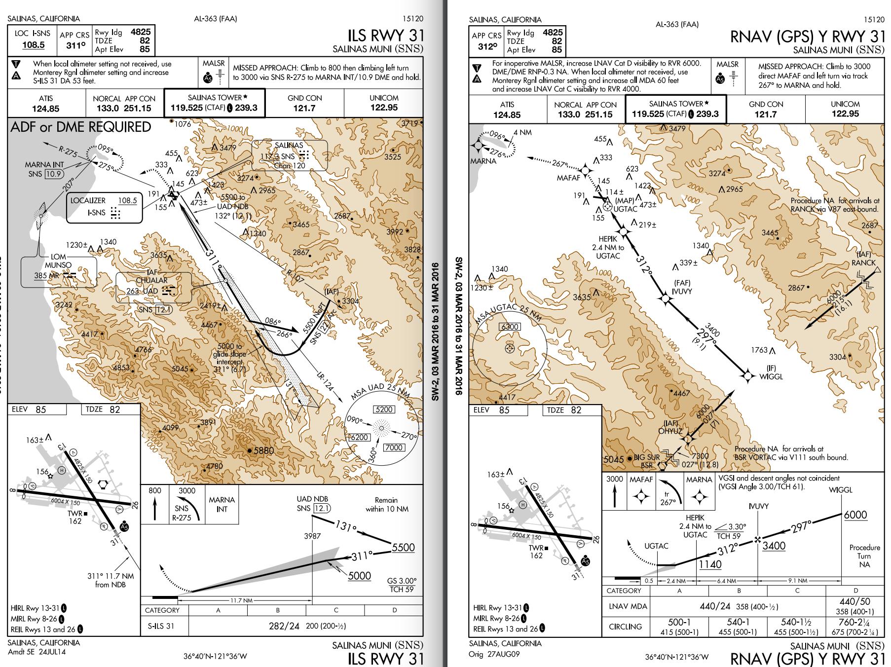
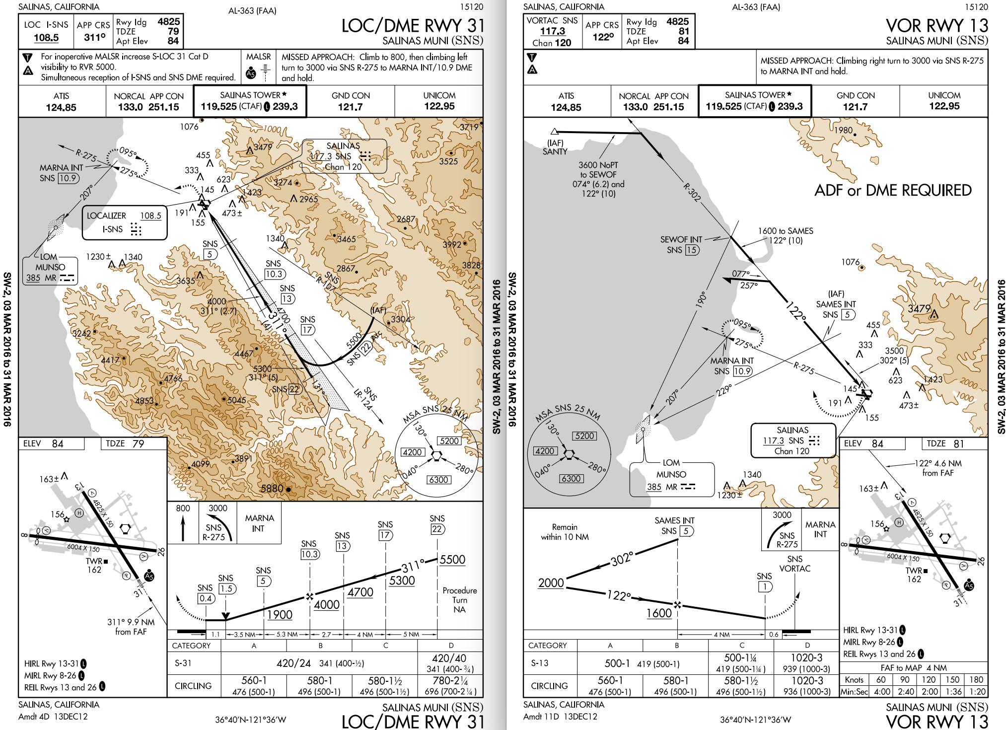
Intro
This is a bit of an odd situation, but they have a good reason for doing what they did.
First of all, each instrument approach is designed to be a stand-alone procedure, and the designers consider that you may not have any of the other approach plates when you are flying a particular procedure. All of the information that you need to fly the approach is included on its individual chart.
Procedure differences
Now, let's look at the ILS and LOC approaches more closely with that in mind. Very often, these two approaches will be combined into one procedure. This has a benefit in that if the glideslope fails, you can simply descend to LOC minimums and continue the approach without having to go missed. In this case though, they are two different procedures. Why?
Equipment requirements:
- The ILS RWY 31 approach requires an ILS receiver, plus ADF or DME (per the note, and is needed to identify the holding point).
- The LOC/DME RWY 31 approach requires the LOC receiver and DME.
The designers wanted someone without DME to be able to fly the ILS procedure. Because of this, the missed approach point is only identified by reaching the decision height (282' MSL in this case) while on the glideslope. If you leveled off sooner, using only the equipment that is required to fly the approach, you have no way to identify the missed approach point (or the visual descent point for that matter). When you reached your self-imposed MDA, you would level off and continue to fly until the MAP if you don't break out. Wherever that may be.... This is why there are no circling minimums.
The LOC/DME procedure on the other hand requires DME, and specifies that the MAP is at 0.4 DME. Now you can descend to the specified minimums and continue along with no visual references until you reach the defined MAP, at which point you would fly the published missed approach procedure. If you are at the MDA and see the airport earlier, then you can circle in accordance with circling procedures if you have been cleared to do so.
The other two procedures require GPS or a VOR receiver, and define the MAP according to the required equipment, so also have circling minimums.
Resolution
Now that we know why they did this, what can we do differently? Plan ahead. You should know the weather before you are given an approach (via preflight planning and the ATIS). You should know which approaches are available and which one that you want to fly before ATC assigns it. If the ATIS states that they are using the ILS RWY 31 approach and you know that you want to land on a different runway, request the specific procedure and runway that you want on initial contact with approach.
As others have said, don't switch procedures in the middle of an approach. If you can't fly it, go missed and get properly setup / familiar with the procedure and fly the procedure when you are prepared for it.
If you decide to continue with the current procedure, you either land straight in, go missed, or request a contact approach to your preferred runway if you break out in time (this option would most likely require prior coordination since there may be traffic following too closely for them to approve it). Do not cancel IFR, as this isn't legal without a 1,000 ft. ceiling, and pilots have been violated for that.
The mountains surrounding the area that you are flying in will not be forgiving if you try to get into a contest of wills or rush and make a mistake.
Lastly, make sure that whatever you decide to do has been coordinated with ATC and that they know what you want to do and give you a clearance to do so. For everybody's well-being, you don't want to surprise anyone by doing something unexpected.


