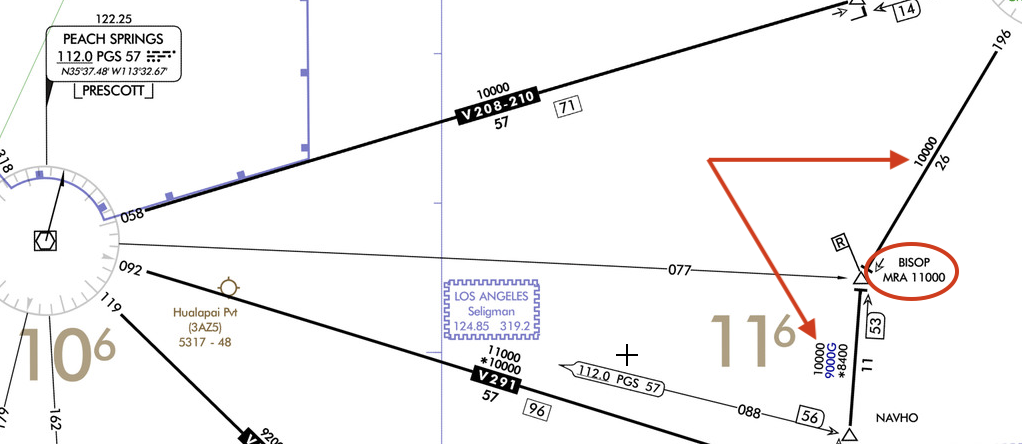
Per Part 95 of Title 14 of the CFRs the Minimum Reception Altitide ("MRA") is defined as "the lowest altitude at which the intersection can be determined using the ground-based navigation aids." Sounds pretty straight forward, but sometimes doesn't make sense on the charts.
For example, notice the intersection BISOP on V257 between GCN and DRK VORs. Both legs of the airway to the north and the south of BISOP have an MEA of 10000. The MEA is defined in the Glossary of the Instrument Procedures Handbook as "the lowest published altitude between radio fixes that assures acceptable navigational signal coverage ...." BISOP is an intersection between DRK r-349 & GCN r-196.
If 10,000 feet guarantees naviational signal at BISOP what's the point of the 11,000 foot MRA? Clearly it must be to receive Peach Springs VOR which is 55nm away, but what is the point? Any aircraft at 10,000ft can receive DRK and GCN as guaranteed by the MEA, and BISOP can be easily identified by the intersection between DRK r-349 & GCN r-196 with nothing more than a VOR receiver. Why would they need a 3rd VOR that requires an altitude higher than MEA in this case?
It makes sense to have an MRA at higher altitude than MEA when its a long straight Victor airway to help aircraft that don't have DME to identify the fix with a cross radial, but BISOP can be identified both by DME and as the intersection of the two radials mentioned above.

