10
$\begingroup$

On several of the ILS and RNAV LPV approaches in my area (and notably the ones I expect for my checkride), I consistently intercept the GS at 0.1-0.2nm before the FAF.

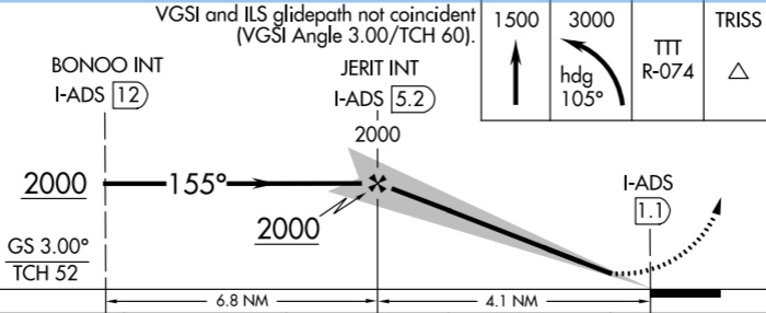
An example: I am flying at exactly 2000 (with correct local altimeter setting) from BONOO to JERIT, but I intercept the GS before reaching JERIT. There are no step-down fixes to worry about.

KADS ILS 15 profile

Should I follow the GS down at intercept, or wait until the FAF and then try to recapture the GS from above? Both seem unwise for different reasons.

I’m looking for a reference sufficient to defend my choice to a DPE.

$\endgroup$
10
  • $\begingroup$ Doesn't that mean that either the instrument approach isn't setup correctly or your aircraft equipment doesn't work correctly? OTOH, 0.1-0.2 NM isn't that much. How accurately can you measure that? $\endgroup$
    – Bianfable
    Commented Sep 8, 2021 at 14:04
  • $\begingroup$ Keep in mind that the FAF on a precision approach is depicted by the lighting bolt symbol and not by the Maltese cross (which is the FAF for a non-precision approach). Often the same altitude (as in your example above), but not always. Not answering your question....just adding info. $\endgroup$
    – user22445
    Commented Sep 8, 2021 at 14:14
  • 2
    $\begingroup$ I wondered if it might be an issue with slant range vs over-the-ground distance measuring (Pythagorean theorem and all). I looked up the distances according to the coordinates given on the 8260-2 form for JERIT and got a hypotenuse of 5.181NM compared to a ground distance of 5.176NM (using Google Earth's claim of 636' elevation at the DME shack, plus a few feet for the antenna). That's a difference of 0.005 DME, so not the answer. $\endgroup$
    – randomhead
    Commented Sep 8, 2021 at 15:11
  • $\begingroup$ @Bianfable I’m identifying the FAF via GPS (WAAS) substituted for DME. When the display counts down to 0.0nm, I am consistently 1/2 to 1 dot above GS on the HSI. $\endgroup$
    – StephenS
    Commented Sep 8, 2021 at 15:46
  • 1
    $\begingroup$ On an ILS approach the FAF is the gs intercept point and is shown by the "indicated" altitude associated with the lightning bolt symbol. In this case 2000 indicated alt. The Maltese cross is the FAF for the non-precision appch (likely a localizer appch). On this approach they (precision and non-precision FAF) are the same. So, if you are at 2000 indicated and you intercept the gs this is the point where you start your descent (on the gs). This does not apply if there are step-down fixes prior to the ILS FAF. (Not the case on this approach) $\endgroup$
    – user22445
    Commented Sep 8, 2021 at 16:18

2 Answers 2

12
$\begingroup$

JERIT is the FAF for the LOC approach, as indicated by the Maltese cross.

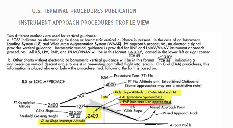
However, the FAF for the ILS approach is not JERIT; it is the Glide Slope Intercept Point (at 2000 ft indicated altitude) shown by the lightning bolt symbol, which in this particular approach happens to be at the same location as published for JERIT.

Keep in mind, however, that the ILS FAF is 2000 ft "indicated" altitude at the interception point of the GS, and if the temperature is above or below ISA (or if you have an incorrect altimeter setting) then you could be at this point (indicating 2000 ft) just prior to or after JERIT.

So, if you are at 2000 indicated and you intercept the GS (whether that happens before, at, or after JERIT), this is the ILS FAF and the point where you start your final approach descent (on the GS). This does not apply if there are step-down fixes prior to the ILS FAF.

See the approach chart legend info below:

TPP legend

$\endgroup$
2
  • 1
    $\begingroup$ Excellent reference! $\endgroup$ Commented Sep 9, 2021 at 14:48
  • 1
    $\begingroup$ Most likely you are flying in warmer than standard temperatures and as the answer suggests follow the GS when it intercepts 2000'. InFO 11009 has a great discussion on how temperature affects the altimeter is relation to the glideslope. faa.gov/other_visit/aviation_industry/airline_operators/… $\endgroup$
    – wbeard52
    Commented Sep 11, 2021 at 5:12
3
$\begingroup$

If you are above all the published altitudes for pre-FAF fixes you can intercept the GS but you must remain above the published minimum altitudes as apposed to remaining on glide slope. Approaches may also have defined intercept altitudes for the glide slope. This article explains why quite nicely;

What this means to pilots is that on some approaches, outside the final approach segment, on a cool day, you might be able to follow the glide slope and remain above all the published minimum step-down fix altitudes. However, on hotter than ISA standard days, an aircraft tracking a glide slope will fly below the minimum altitude for the published step-down fixes. This could result in loss of separation between parallel or crossing traffic maintaining assigned altitude by reference to an altimeter. To avoid a loss of separation, and a possible pilot deviation filing by ATC, pilots flying an ILS with step-down fixes prior to the final approach fix must comply with the minimum step-down altitude, even if it means remaining above the ILS glide slope until reaching the final approach fix.

and also (bolded for emphasis)

The ILS glide slope is intended to be intercepted at the published glide slope intercept altitude. This point marks the precision approach final approach fix (PFAF) and is depicted by the “lightning bolt” symbol on U.S. government charts or the beginning of the feather in the profile view on Jeppesen charts. Intercepting the glide slope at this altitude marks the beginning of the final approach segment and ensures required obstacle clearance during descent from the glide slope intercept altitude to the lowest published decision altitude for the approach. Interception and tracking of the glide slope prior to the published glide slope interception altitude does not necessarily ensure that minimum, maximum, and/or mandatory altitudes published for any preceding fixes will be complied with during the descent. If the pilot chooses to track the glide slope prior to the glide slope interception altitude, they remain responsible for complying with published altitudes for any preceding step-down fixes encountered during the subsequent descent.

So depending on the scenario you may be able to use the glide slope to help you get an idea of where you are but altitude step downs must be followed prior to the FAF or intercept altitude.

$\endgroup$
7
  • $\begingroup$ I don’t understand which way you’re telling me to go here. The published altitude at the FAF is 2000, I’m flying at exactly 2000, and yet I intercept the GS before the FAF. Should I follow it down or not? $\endgroup$
    – StephenS
    Commented Sep 8, 2021 at 13:52
  • $\begingroup$ @StephenS it depends on the situation/approach you can follow it if you are below the GS intercept altitude (if there is a published one) and before the FAF. You can use it as a helper reference so long as you stay above the published step down fixes if no GS intercept altitude is published. In the approach you have here the GS intercept IS the FAF so you can not use it as an official reference prior to the FAF (although this whole approach is only at 2000 prior to the FAF so you could safely fly the GS down prior to the FAF since you are above the min altitude. $\endgroup$
    – Dave
    Commented Sep 8, 2021 at 14:17
  • $\begingroup$ @StephenS on the approach in your question 2000 is the gs intercept altitude and also the precision FAF (Maltese cross is not the FAF for a precision appch). However, since the altitude shown at the non-precision FAF (Maltese cross, i.e. 2000) is the same as the gs intercept altitude/precision approach FAF (depicted by the lightning bolt symbol) that is where your descent begins on the gs. Based on this approach I can't understand why/how you're intercepting the gs before the published gs intercept altitude (2000) if you have the correct altimeter setting. $\endgroup$
    – user22445
    Commented Sep 8, 2021 at 15:04
  • 2
    $\begingroup$ @757 the "correct" altimeter setting only provides truly valid information at ground level, right? If the meteorological conditions are other than standard, the pressure lapse rate is different than what the altimeter is calibrated for and it will not match reality. This comment thread on Reddit seems relevant, as does this InFO someone linked. $\endgroup$
    – randomhead
    Commented Sep 8, 2021 at 15:22
  • 1
    $\begingroup$ @randomhead of course what you say is true (could be non-standard temp). But another thing that can have you intercept the gs at 2000 indicated altitude (before Jerit) is an incorrect altimeter setting. That was my point. (Jerit is 2000 true altitude and gs intercept altitude [of 2000] is indicated altitude as shown by lightning bolt symbol) $\endgroup$
    – user22445
    Commented Sep 8, 2021 at 15:55

You must log in to answer this question.

Not the answer you're looking for? Browse other questions tagged .