15
$\begingroup$

Svalbard-Longyear (ENSB) has one particular approach (the RNAV (GNSS) - A approach to runway 28) whose missed-approach course is... oddly-shaped, to say the least:
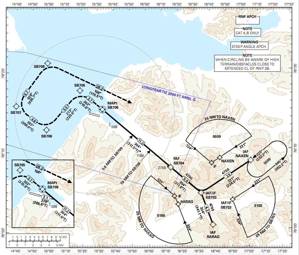
and here I thought the missed approach was supposed to be the EASY part (PDF by Avinor; screenshot and cropped by me.)

If the pilots can't see the runway by the time they reach SB709, they have to make a right-angle turn to the left just before reaching SB705, followed by a series of three right turns that end up with the aircraft aimed at NAXEN and its holding pattern (and flying directly over the substantial mountains immediately to the north of Adventfjorden en route).

The hockey-stick-shaped missed-approach course can't be for obstacle clearance, given that all this manoeuvring is carried out over the water - indeed, the other two approaches to runway 28 (the unadorned RNAV (GNSS) approach and the localiser approach) have missed-approach courses which each include but a single, wide, conventional turn en route to the holding patterns at the NAXEN waypoint and the Longyear NDB, respectively - so why does this particular approach have such a weird missed-approach course?

$\endgroup$
1
  • 8
    $\begingroup$ My guess would be to allow time to climb over terrain. On the regular RNAV you would go missed above 1400 ft. But on this app you could go missed at 650 ft and would need time to climb over the 3000 ft terrain. $\endgroup$
    – TomMcW
    Commented Sep 19, 2019 at 2:27

2 Answers 2

24
$\begingroup$

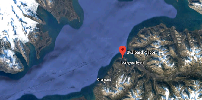
If you look at satellite imagery it looks like you have very high terrain to the west of the runway. The water would be the primary area available for a climb back to obstacle clearance altitude. Looks like the MAP just routes you with sufficient time to climb to the MA altitude.

satellite imagery
(Google Maps)

$\endgroup$
13
$\begingroup$

As Alexander already said in his answer, the turns over water are executed to gain enough altitude before turning back over the terrain.

RNAV-A vs RNAV approach plate (left: RNAV-A, right: RNAV approach chart).

The difference between the RNAV-A approach and the other two (RNAV and LOC) is the required minimum climb gradients for these two approaches. You find them at the bottom of the approach charts (percent values before the *) for the latter two:

RNAV minimum missed approach climb gradient (RNAV)

LOC minimum missed approach climb gradient (LOC)

The OCA (Obstacle Clearance Altitude) is different depending on the missed approach climb gradient (and approach category), thus ensuring enough terrain clearance with the normal turn to NAXEN (RNAV) or LON (LOC).

The RNAV-A approach does not list a minimum approach climb gradient and can therefore be flown by aircraft with a lower climb performance, which requires more track over water before turning back, hence the funny shape. Note however, that the approach chart says

CAT A, B only.

for the RNAV-A, so it is limited to aircraft with a maximum reference speed of 120 kt.

$\endgroup$
0

You must log in to answer this question.

Not the answer you're looking for? Browse other questions tagged .