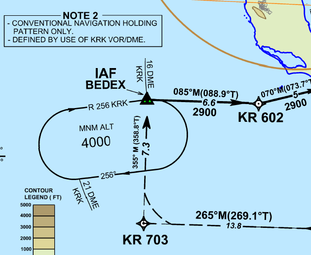
While reading in the PANS-OPS (Doc 8168-OPS/611 Volume II) about holding procedures, I came across Chapter 7 of Part III section 3 defining RNAV holding procedures and differentiates them from conventional ones described at an earlier section. Under 7.1.3 is mentioned that
Location and number of holding patterns [...] The normal location would be at one of the IAFs. RNAV holding waypoints shall be located so that they are referenced to and verifiable from specified radio navigation facilities. The holding waypoint (MAHF) is a fly-over waypoint.
At that point I recalled the GNSS RNAV procedure from BEDEX for LGKR airport. There we can see that note #2 warns us that the holding is a conventional one. But why can't it be treated as an RNAV? It's on the IAF, it's defined by KRK VOR/DME (thus verifiable and from specified radio navigation facilities), even the path to MAHF (Missed approach holding fix) seems to be a fly over.
The rest of the chapter is defining the geometry protected areas etc that from the description I would expect them to be smaller than that of the conventional holding pattern:
Aircraft equipped with RNAV systems have the flexibility to hold on tracks which are defined by the RNAV equipment and to use procedures which are less rigid than those used in conventional holdings. The benefits of using this technique include the optimum utilization of airspace with regard to the siting and alignment of holding areas as well as, under certain circumstances, a reduction of holding area airspace.
So what makes conventional holdings "incompatible" to RNAV?

