What a fix is has been answered here but for now let's just say it's a known location that a pilot can navigate to if he has the right equipment. Fixes are shown on various charts and approach plates.
As for using those fixes on an instrument approach, there are lots of variations and details but again, let's ignore most of that for now. The basic concept is very simple:
- Fly to an Initial Approach Fix (IAF)
- Fly to other fixes as needed to execute the approach
- Land (or go missed)
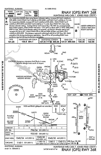
For example, here's the RNAV (GPS) 36R approach at KHSV:

You can see at the bottom of the map portion of the plate that both MASHA and FEWER are IAFs, so that's where the approach starts. Let's say you're approaching from the south-west and you've already descended to a reasonable altitude for starting an approach, following a STAR or vectors from ATC.
ATC says something like "N12345 proceed direct MASHA, cleared for the RNAV 36R approach". That means that you are now cleared to execute the approach as shown on the chart, with no further instruction from ATC (although they might have vectored you towards the IAF initially).
The chart tells you that at MASHA you need to be at at least 3000ft MSL so you simply fly there at or above that altitude. Since it's a GPS approach, you load it and activate it in your GPS unit, and you can follow the GPS track to MASHA.
After MASHA, the next fix is ENIKY and the GPS track will lead you east to that fix (which is a heading of 091° from MASHA). The profile view at the bottom of the plate shows that you must still be at or above 3000ft at ENIKY. Then you turn left to 002° and fly to UJOTY, where you must be at or above 2700ft. Then you continue to GEPDE at or above 1180ft. Then you land :-)
Of course, I'm ignoring a huge amount of detail here - like everything else printed on the approach plate! - but since this question is about fixes the main point is that they're simply a series of waypoints that you fly over (or past) to get to the runway. And obviously you also have to control your altitude as you descend, but the altitude is defined by the approach procedure, it isn't part of the definition of the fix itself. The same fix can be used in multiple approaches: MASHA and FEWER are also the IAFs for the RNAV (GPS) 36L approach).
Even though different approaches define and use fixes in different ways, the basic idea is always the same: just fly from one fix to the next until you get where you're going.


 .
.