5
$\begingroup$

How do I know which highways and landmarks on a VFR sectional align with which real-world features? Is there a way to overlay the VFR sectional map from the FAA on top of Google Maps or Bing?

Edit: I'm asking in relation to VFR flight in general where you are responsible for your own navigation, and not about a specific route of flight.

$\endgroup$
3
  • $\begingroup$ Do you happen have any particular problem with any area? Or you just want to have a general idea how is it done? $\endgroup$
    – vasin1987
    Commented Jun 2, 2019 at 14:23
  • $\begingroup$ @vasin1987 Now that I think about it, both. To be specific, I'm having problems with Hawthorne, Santa Monica, and John Wayne (including that pesky permanent Disneyland TFR). What's the process in general? $\endgroup$
    – slantalpha
    Commented Jun 2, 2019 at 14:59
  • $\begingroup$ I don't remember details, but I have used overlays of VFR sectional charts in Google Earth $\endgroup$
    – J W
    Commented Jun 4, 2019 at 2:16

1 Answer 1

1
$\begingroup$

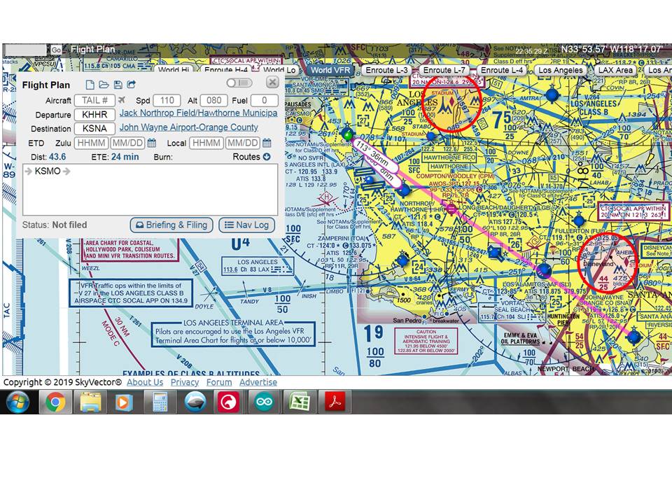
Seems to me you're going to be directed by SoCal approach that whole route per the routing shown in Skyvector.com, especially with the LAX Class B right there, and the TFR will be the last of your worries. Put your enroute and the final destination into your GPS (Foreflight or whatever), and be ready for deviations. enter image description here

$\endgroup$
4
  • $\begingroup$ Thanks. I'm actually asking in a more general context of being on a VFR flight where you are responsible for your own navigation, and not about being on a specific route. I mentioned examples of specific airspace, but didn't mean to imply a particular route between them. $\endgroup$
    – slantalpha
    Commented Jun 3, 2019 at 18:25
  • $\begingroup$ Well, if VFR on your own, the sectional is your friend. It has the useful shown. I don't think you'll be on your own flying around LAX. ATC is there to help you out, use them. Looking at maps.google.com centered around Hawthorne, CA, there are so many highways it would be hard to pick one or two out follow them without many hours flying over to recognize things. GPS with headings & distance (or moving map display) will really save your butt there. $\endgroup$
    – CrossRoads
    Commented Jun 3, 2019 at 18:44
  • $\begingroup$ True, use ATC if available, but it's busy airspace and they don't always have time to give you vectors, or you might not be able to get a word in on the radio. GPS units can also fail. A (good) pilot should be able to navigate comfortably without a GPS and only with VFR landmarks. GPS can be used if available. $\endgroup$
    – slantalpha
    Commented Jun 3, 2019 at 19:59
  • $\begingroup$ Hope you know your local landmarks! Scooting along at 2000 ft and 2500 ft, you'll certainly get a good view of them. $\endgroup$
    – CrossRoads
    Commented Jun 4, 2019 at 3:08

You must log in to answer this question.

Not the answer you're looking for? Browse other questions tagged .