27
$\begingroup$

How does ILS (Instrument landing system) work?

ILS

  • I know it provides guidance to the runway by two signals, one modulated at 90 Hz, the other at 150 Hz, but how the airplane lock on those signals?

ILS

  • Which system in the plane is responsible for the ILS? Is the autopilot responsible for it?
  • If autopilot is used for an ILS approach, at what point does the pilot take manual control?
$\endgroup$
0

2 Answers 2

26
$\begingroup$

The ILS works using two components, a localizer and a glideslope. The frequencies for the localizer are between 108.1-111.95 MHz and the glide slope between 329.15-335.0 MHz. These frequencies are the carrier waves that the modulation you mention takes place upon. A pilot is only concerned with the localizer frequency as the navigation equipment knows the paired glideslope frequency for any given localizer frequency.

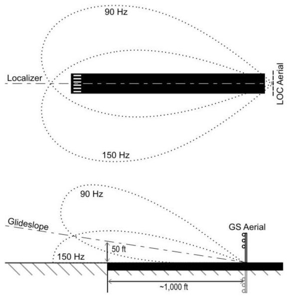
The equipment for transmitting the signals is pretty well described in your question. The localizer antenna broadcasts two lobes down the length of the runway for a few miles (typically 18 nm, but some airports like LAX have a much longer serviceable distance). The glideslope antenna sits around the 1000 ft touchdown zone markers on the runway, offset a little bit from the runway. It broadcasts a its own two lobes centered around a 3 degree slope (this can vary by installation). The glideslope is generally usable about 10 nm from the runway, but is generally not used that far out.

The equipment in the plane responsible for using this signal comes in a few parts, an antenna, a radio and a navigation instrument.

The localizer signal is received the antenna used for the normal navigation signals (VOR) and there will be an additional antenna for the glideslope signal. These signals will first go to a nav radio, which the pilot uses to select the localizer frequency (or a VOR frequency). If a localizer frequency is selected, the radio will also listen on a specific glideslope frequency.

The data from the radio is then sent to whatever instrument you are displaying the data on.

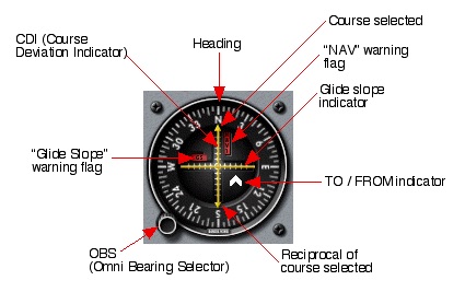
The most primitive instrument is the VOR head with glideslope-type of needled navigation instrument.
enter image description here

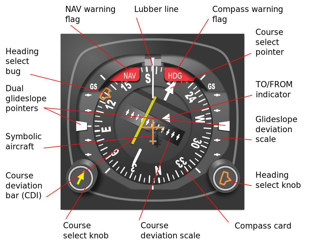
A step up from that is an HSI, which is a bit more intuitive to fly and has better facilities for handling localizer back courses.
enter image description here

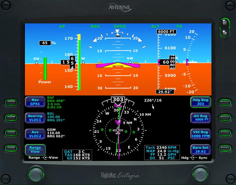
On the top end you have electronic primary flight displays that display data on a CRT or LCD screen.
enter image description here

The basis of all of these are following two needles that are shown to the pilot. One moves side to side and tracks the localizer, and the other moves up and down and tracks the glideslope. If both of these are centered you are in the middle of both beams and on course. The position of the needle is determined by which lobe of the transmitter is being received stronger than the other. When both lobes are received equally the needle will be centered.

To your last question, the pilot has control over the airplane for the entire approach. The ILS does not take over the airplane. The autopilot may be slaved to follow either just the localizer, or both the localizer and glideslope, or the pilot may hand fly the approach. In both cases however, the pilot is in control, not the ILS.

The ILS is usable for at least 10 miles from the antennae. At many airports you will track the localizer portion of the signal much further out than this. You will stop using the ILS normally at 200 ft above the ground, although there are special ILS approaches with lower minimum altitudes that require special equipment and training. The majority of ILS approaches however, require the pilot to observe certain visual cues before descending below 200 ft AGL.

$\endgroup$
3
  • $\begingroup$ Thanks... One more question, you said that 'a navigation instrument' is responsible for using the signal. Is it part of the auto-pilot system? $\endgroup$ Commented Mar 25, 2014 at 14:11
  • 3
    $\begingroup$ @GabrielBrito no, not directly. If installed, a flight director will interface with the nav instruments and display a course to fly. An autopilot will follow the flight director. Neither a flight director or autopilot is necessary to fly a normal ILS approach. $\endgroup$
    – casey
    Commented Mar 25, 2014 at 14:17
  • 6
    $\begingroup$ @GabrielBrito To clarify something you might be confused about: The ILS isn't there to help the autopilot; its development was wholly unrelated to autopilot technology. It was created to help a pilot land in bad weather; before the ILS was invented, a pilot who tried to land in poor visibility took their life into their hands. ILS was developed as part of the same project that introduced artificial horizons and precision altimeters, and is no more tied to the autopilot than those are (like those, the main purpose is to let a pilot fly without seeing outside). $\endgroup$
    – cpast
    Commented Mar 15, 2015 at 4:36
8
$\begingroup$

To add a little more detail on the receiver side and how it's used;

The localiser and glideslope signals are transmitted on different frequencies (the "carrier" frequency) and these are filtered out to leave a mix of 90Hz and 150Hz for each one. The 90 and 150 are then filtered out separately.

If you have more 90Hz than 150Hz, you are too far left on the localiser or, too high on the glideslope. The guidance indicator is just a display of the ratio between 90Hz and 150Hz. A 50% ratio means just right!

On your question of "for how long?", a common procedure (it might be different for a particular field or approach) is to fly towards the centre line of the localiser and below the glideslope at an angle of about 30 degrees to intercept the localiser at about 10 miles out.

ATC will vector the aircraft to this point (e.g. Speedbird 93, descend and maintain 1500 feet, turn left heading 300 degrees. Cleared ILS approach 27L report established). The autopilot is usually in approach mode meaning that it will capture the localiser, and in turn the glideslope, and follow the ILS down.

When the localiser is captured, the autopilot will turn the aircraft onto the centre line and the pilot reports established back to ATC.

It is normal procedure to capture the localiser at a height lower than the glideslope at the point of capture so that you capture the glideslope from below. This is for safety. If you captured the glideslope from above, then the aircraft may well descend through the glideslope then level out to recapture. Descending below the glideslope, at what might well be hundreds of feet per minute, is not good.

Finally, most procedures call for a stabilised approach (correctly configured, following the ILS, speed correct, check lists complete, no large deviations in course, height or power settings) by 1000' or go around. Many pilots, depending on their airlines procedures and conditions, will disconnect the autopilot for the last 1000 feet, sometimes to give practice to the first officer. Some aircraft are cleared all the way down (autoland) but that will also depend on company operations, crew currency and local procedures.

[EDIT] I deliberately left out the harmonics. I figured I only had one page ;)

$\endgroup$
2
  • $\begingroup$ By "harmonics" you mean the side-lobes? They are not harmonics, they are side-effect of use of interference for creating the directional signal. But that would be a question more suitable for Electrical Engineering[electronics.stackexchange.com]. $\endgroup$
    – Jan Hudec
    Commented Mar 26, 2014 at 12:29
  • 2
    $\begingroup$ @Jan. Nope, I mean the harmonics. The 90 and 150Hz signals, plus the carriers themselves, mix together to form beat frequencies with multiple harmonics. I was just trying to avoid some smart Alec critiquing my answer as I had not discussed the filtering of harmonics, which would also be better suited to some other site. Side lobes are something else altogether. $\endgroup$
    – Simon
    Commented Mar 26, 2014 at 19:40

You must log in to answer this question.

Not the answer you're looking for? Browse other questions tagged .