10
$\begingroup$

I had assumed during a WAAS approach when the GPS is in LPV mode, both lateral guidance and vertical guidance are generated from GPS/WAAS signals and the pitot-static system should have no effect on its vertical guidance. This is in contrast with LNAV/VNAV approach, where the vertical guidance comes from the barometric system, the same source as altimeter.

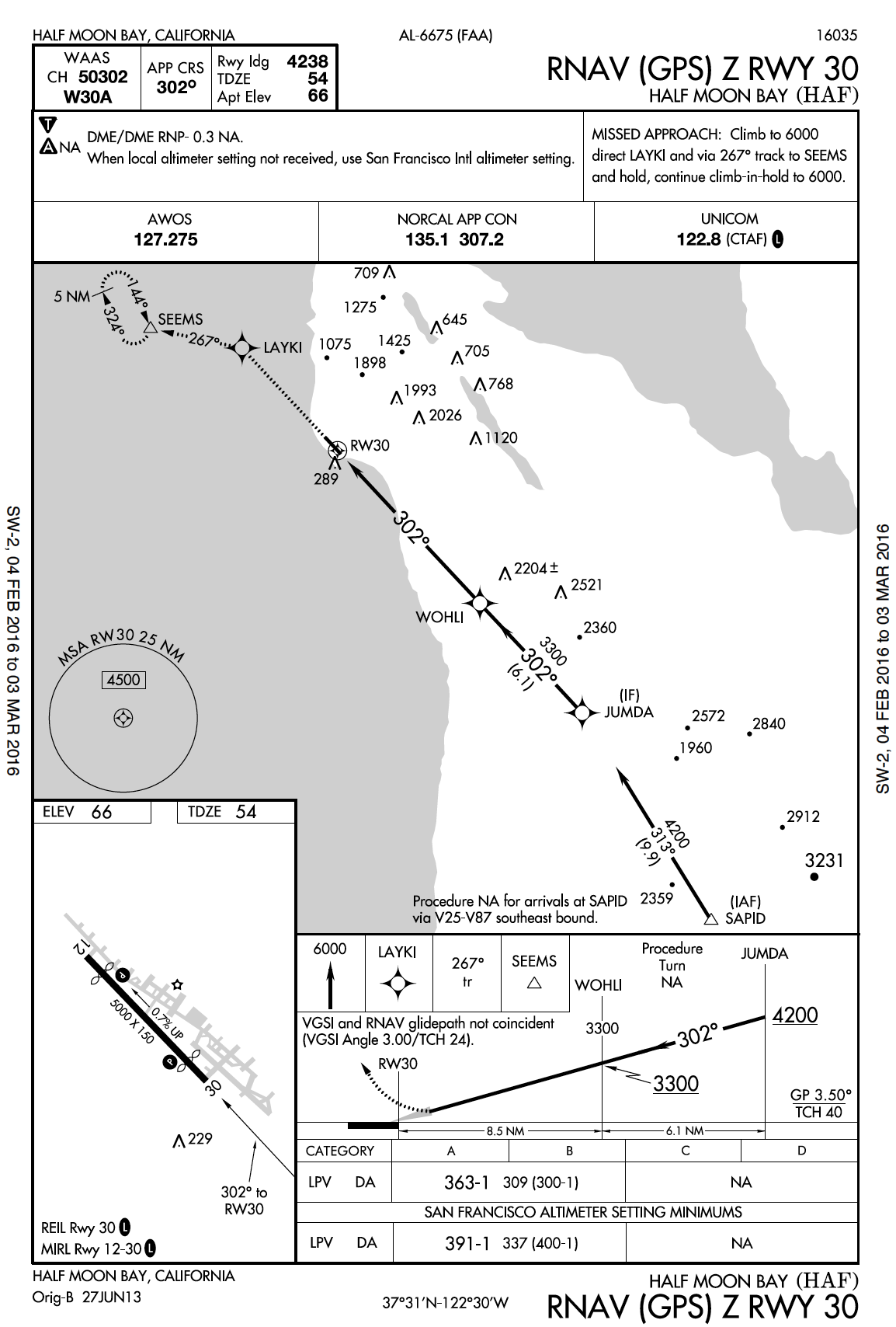
However, when I read RNAV (GPS) Z RWY 30 @ KHAF, I will get a different DA if I use a different altimeter setting. So, why does altimeter settings matter to the DA in an LPV approach?

enter image description here

$\endgroup$
2
  • 1
    $\begingroup$ To directly answer your question, "...why does altimeter settings matter to the DA in an LPV approach?", it is because the DA is still predicated on the barometric altitude. $\endgroup$ Commented Feb 28, 2016 at 20:04
  • $\begingroup$ @Porcupine911: It make sense. The minimum (DA in this example) given in the approach plate is baro-minimum, as against radar-altimeter minimum or GPS-altitude minimum. $\endgroup$ Commented Feb 29, 2016 at 3:26

1 Answer 1

9
$\begingroup$

Short Answer:

No, the vertical component of LPV approach performance is based on WAAS GPS input, not the altimeter or barometric system.

Longer Answer:

Your assumption about LPV performance is correct: Baro-VNAV is not used for LPV approaches.

On any type of approach with a Decision Altitude (DA), the aircraft's arrival at the DA is determined by the pilot's reading of the aircraft's sensitive altimeter.

If the altimeter is set to an altimeter setting report from a distant reporting station, SFO in this case, then the DA may be increased to give additional altitude margin to allow for variance in local atmospheric pressure.

This is true for the DA or Minimum Descent Altitude (MDA) on any approach, whether a GPS approach or not. See the MKT ILS 33 and MKT RNAV 15 for other examples of this. See the following excerpts from the Aeronautical Information Manual on altimeter settings for approaches (emphasis mine):

5-4-5
a.
4. Approach minimums are based on the local altimeter setting for that airport, unless annotated otherwise; e.g., Oklahoma City/Will Rogers World approaches are based on having a Will Rogers World altimeter setting. When a different altimeter source is required, or more than one source is authorized, it will be annotated on the approach chart; e.g., use Sidney altimeter setting, if not received, use Scottsbluff altimeter setting. Approach minimums may be raised when a nonlocal altimeter source is authorized. When more than one altimeter source is authorized, and the minima are different, they will be shown by separate lines in the approach minima box or a note; e.g., use Manhattan altimeter setting; when not available use Salina altimeter setting and increase all MDAs 40 feet. When the altimeter must be obtained from a source other than air traffic a note will indicate the source; e.g., Obtain local altimeter setting on CTAF. When the altimeter setting(s) on which the approach is based is not available, the approach is not authorized. Baro−VNAV must be flown using the local altimeter setting only. Where no local altimeter is available, the LNAV/VNAV line will still be published for use by WAAS receivers with a note that Baro−VNAV is not authorized. When a local and at least one other altimeter setting source is authorized and the local altimeter is not available Baro−VNAV is not authorized; however, the LNAV/VNAV minima can still be used by WAAS receivers using the alternate altimeter setting source.

Note that Baro-VNAV is a type of VNAV system which uses barometric altimetry as a basis for vertical navigation performance. An LNAV/VNAV approach can be flown using WAAS equipment without a Baro-VNAV system.

$\endgroup$
8
  • $\begingroup$ So what you're saying is that, although vertical guidance is being provided by WAAS the DA is set by baro altimeter? $\endgroup$
    – TomMcW
    Commented Feb 28, 2016 at 22:21
  • 1
    $\begingroup$ @TomMcW The DA is the altitude at which the pilot decides whether to continue with the approach or go missed; the pilot determines arrival at this altitude by reference to the aircraft altimeter. Baro-VNAV is a vertical navigational system to which gives the required navigational performance for the VNAV component of LNAV/VNAV approaches (though other systems such as WAAS can also provide this level of performance). Does that answer your question? I wasn't quite certain what you meant by baro altimeter. $\endgroup$
    – J W
    Commented Feb 28, 2016 at 22:28
  • 1
    $\begingroup$ I guess what I'm summarizing from your answer is that the although the WAAS guidance is not affected by the altimeter setting the FAA still sets the DA by the pressure altimeter and not the altitude calculated by the GPS. Is that correct? $\endgroup$
    – TomMcW
    Commented Feb 28, 2016 at 22:33
  • $\begingroup$ @TomMcW That's correct. You probably already understand this, but in an attempt to be perfectly clear, let me reiterate that pilots rely on the indicated altitude as seen on the sensitive altimeter, not the altitude given by the GPS (which may be the true altitude, depending on the GPS precision). $\endgroup$
    – J W
    Commented Feb 28, 2016 at 22:56
  • 1
    $\begingroup$ @TomMcW Yes, WAAS altitude is very precise and reliable. That's a good question—probably a good new question on it's own! The answer is long and includes the recent development of precise GPS and the usefulness of having all aircraft with altimeters set the same. It's simpler. $\endgroup$
    – J W
    Commented Feb 28, 2016 at 23:15

You must log in to answer this question.

Not the answer you're looking for? Browse other questions tagged .