3
$\begingroup$

The chart supplement for KUGN here says "AIRSPACE: CLASS D SVC 1200-0200Z other times CLASS E."

Does that mean that when the tower is closed, the class D airspace switches to class E surface area entirely, or is there class G from the surface up to 1200', and class E from 1200 up to 18000'?

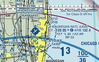
KUGN

$\endgroup$

2 Answers 2

3
$\begingroup$

SVC means Service, not Surface, that would be SFC. 1200-0200Z is a time range, that means the zone is class D between 12:00 UTC (that's what the Z or Zulu time means) and 0200Z, which would translate to 07:00-21:00 local daylight savings time in Waukegan. Basically, the tower is open during those times and then it closes so it becomes a class E zone, traffic would presumably use unicom if the airport is still open.

The zone is not defined in the sheet, you'd have to look at a chart to get the details on size, shape and how high it goes.

$\endgroup$
4
  • $\begingroup$ Yep, SVC means "service", but that still begs the question if it is class G or E airspace beginning from the surface of the ground at the airport. $\endgroup$
    – slantalpha
    Commented Jul 22, 2018 at 8:21
  • 1
    $\begingroup$ It depends on where you are in the zone @jeff0000, many zones have tiers, for example an airport's zone could be sfc to 3000ft around the airport, then 5nm away it is 1500ft to 3000ft. So if you're talking at the airport then it's class E from the surface, otherwise you need to look at a chart. $\endgroup$
    – GdD
    Commented Jul 22, 2018 at 8:29
  • 1
    $\begingroup$ This is more of a clarification of the question than an answer… $\endgroup$ Commented Jan 19, 2022 at 16:14
  • $\begingroup$ Per the chart, when the Tower is closed, CTAF is 120.05 (the same freq as Tower was); it is not the same as Unicom on 122.95. This is common at part-time towered airports. $\endgroup$
    – StephenS
    Commented Jan 19, 2022 at 16:21
2
$\begingroup$

The Chart Supplement will describe only the surface-level airspace. If it says "...other times CLASS E" that means the Class E will begin at the surface. If it says "...other times CLASS G" that means the Class E will not start at the surface, and you will have to check the official airspace definitions (FAA JO 7400.11) to determine if the G goes up to 1200' or only 700'.

You can also check the VFR sectional; you will see that UGN is completely surrounded by a fuzzy-magenta "E starting at 700'" area, so you know that even if the Chart Supplement had listed the surface airspace as Class G the controlled airspace would have started at 700'. But it is possible for an airport to not be surrounded by this fuzzy-magenta marking, and then you really would have no way of knowing where controlled airspace begins without consulting the 7400.11.

$\endgroup$
1
  • $\begingroup$ Apparently at one point the Chart Supplement did intend to give information regarding the status of the overlying airspace, and actually adopted an entry in the LEGEND to this effect-- which is potentially confusing, because this information never actually appeared in any of the actual airport entries-- see aviation.stackexchange.com/q/86583/34686 .Actually though this would pertain to if the entry said "other times Class G". If it's "other times Class E" it's a moot point because Class E basically has no upper limit. $\endgroup$ Commented Jan 19, 2022 at 15:15

You must log in to answer this question.

Not the answer you're looking for? Browse other questions tagged .