3
$\begingroup$

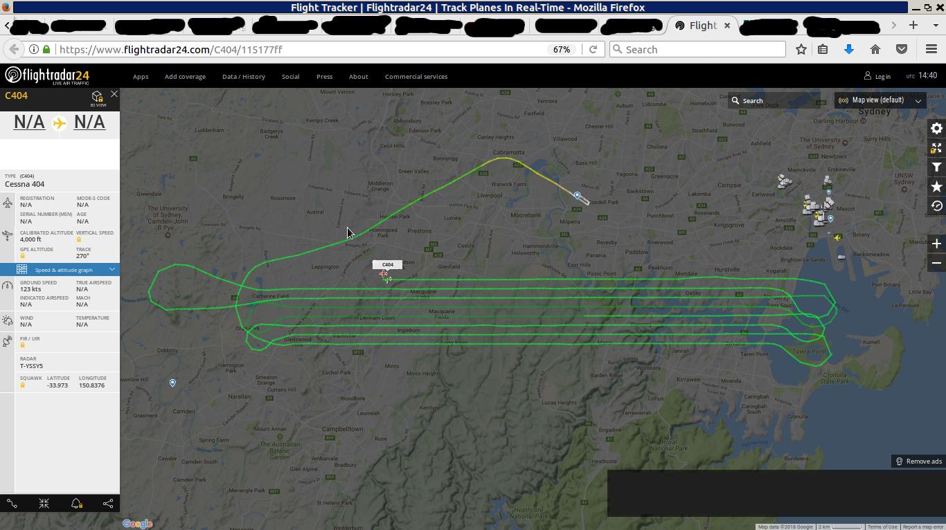
As I write this, a mystery plane is going back and forth over south Sydney, Australia:

Mystery Plane Sydney

The plane took of at Bankstown, flies straight from West to East and back, with a distance between paths of about 600m. It maintains a steady height of ca. 4100ft at a speed 120kts.

It is a Cessna 404, but flightradar24 provides no call sign or any other ID.

I noticed the plane ca. 00:30 on 10 May 2018, as it was at its 8th "lap", and took the above screen shot. It may have gone on for a while, perhaps for an hour or more.

As it's night, no markings on the plane are visible. It has the usual white flashers on the wing tips and the top of the rudder, and the red and green marker lights. The plane is quiet loud (prop), but that's most likely only because it's night and there's no other sound sources in my suburb.

Does anyone have an idea what that plane could be, and what the purpose of such flights could be? Obviously, they (whoever they may be) waited until after the curfew of Kingsford Smith (23:00) to not get in the way of commercial traffic.

Might be similar to this question, but I have no way of knowing whether it is the same. Italy and Australia are different countries. E.g., to my knowledge, Europe doesn't permit Police planes or helicopters above urban areas without reason. Australia does.

$\endgroup$
7
  • $\begingroup$ These patterns are often for aerial photography, mapping, or occasionally, search and rescue operations. $\endgroup$
    – abelenky
    Commented May 9, 2018 at 15:29
  • $\begingroup$ @abelenky Photography at night? That scares me. The only ones who I can think of would engage in infrared photography at night are law enforcement. You know, trying to find cannabis plantations inside buildings... $\endgroup$
    – Lorca
    Commented May 9, 2018 at 15:44
  • $\begingroup$ Tip: You can drag the tab into a new window to save the censoring of the tabs, or just use Firefox's built-in screenshot tool. $\endgroup$
    – user14897
    Commented May 9, 2018 at 15:46
  • 1
    $\begingroup$ Night time surveys are often preferable because there won't be moving traffic and all the activity of the daytime. Its not necessarily color photography nor infrared. LIDAR (laser surveys of elevation) are a prime example of a survey best done at night. $\endgroup$
    – abelenky
    Commented May 9, 2018 at 16:19
  • 1
    $\begingroup$ @abelenky Also, night air is often calmer and the ambient temperature is cooler, providing a more beneficial environment for e.g. LIDAR and IR surveys, where the plane‘s altitude must be kept rock steady. $\endgroup$ Commented May 10, 2018 at 6:34

3 Answers 3

3
$\begingroup$

With a path like that its most likely surveying something. There are a handful of 404's registered in Australia for areal survey, you can find them on this list.

$\endgroup$
5
  • $\begingroup$ Interesting link, thanks a lot. I'd pay real money to know exactly what they are surveying in the suburbs. $\endgroup$
    – Lorca
    Commented May 9, 2018 at 15:40
  • $\begingroup$ They could be doing anything, Radar for topographic maps, checking GPS reception, light pollution survey etc etc. $\endgroup$
    – Dave
    Commented May 9, 2018 at 15:46
  • $\begingroup$ If it's light pollution, I'm all in for this kind of stuff. There's way too many street lights, buildings illuminated nonsensically etc. Is GPS reception at 4100ft meaningful for GPS reception on ground level? $\endgroup$
    – Lorca
    Commented May 9, 2018 at 15:48
  • $\begingroup$ I rely on GPS more at 4100Ft. than I do at ground level... (comments are generally not for back and fourth but Id be happy to discuss this more in the chat ) $\endgroup$
    – Dave
    Commented May 9, 2018 at 15:52
  • $\begingroup$ This aircraft would have a shockingly accurate GPS system onboard so that photogrammetry could be performed on the data at a later time. Ironically FAA and CASA regulations require that the output of such systems (if visible to the pilot) be marked as unusable for NAV. Even though the mapping GPS will be 1 or 2 orders of magnitude more accurate it probably is not designed or maintained with oversight of a regulatory body. $\endgroup$
    – user28387
    Commented May 9, 2018 at 17:57
1
$\begingroup$

Flights that have that kind of pattern are usually doing some kind of aerial photography. Another possibility is that the plane could be collecting LIDAR data to get a 3D model of the city. Sometimes planes are hired by the cell phone companies to scout good places to put a cell tower. There could be any number of reasons that someone would fly parallel pattern route.

$\endgroup$
2
  • $\begingroup$ Thanks for the answer. Wouldn't it be better to get a 3D model straight from the building registrations etc? They would know exactly where each building is, the sizes etc. Unless they want the ground shape, of course. A new mobile phone tower on the other hand would really be in order. Reception sucks here... $\endgroup$
    – Lorca
    Commented May 9, 2018 at 15:42
  • $\begingroup$ @Lorca contacting all the right groups for that information would probably be a lot of work, and the data may not be that precise or even accurate. It's also possible that the municipalities get their information from this sort of survey. $\endgroup$
    – fooot
    Commented May 9, 2018 at 19:57
1
$\begingroup$

If the plane is operational at night it is a LiDAR capture. There is a very limited scope for Thermal Infrared (TIR) and as such those captures are usually spot captures rather than swath (BrEnglish swathe) capture you are seeing here. Visible and Near IR (NIR) imagery must be captured during daytime whereas some TIR must be captured at night. Although LiDAR can be operated any time the weather permits many crews opt for nighttime to avoid traffic, especially in congested airspace.

These sort of missions are flown daily all over the world. In Australia there are dozens of planes engaged in aerial survey of all kinds, not including mineral exploration in WA. In the USA and Europe aerial survey craft number into the hundred in the air each day. While these missions occur all over the country, they will have a local transponder in controlled airspace for flight following.

Based on the line lengths and spacings as well as the aircraft altitude, I would speculate that this is a very high precision survey. Data of this quality would be suitable for building mapping, very high resolution DEMs and in cases where cutting edge technology is present, infrastructure mapping

I'll get you some links on likely technologies and operators later.

$\endgroup$

Not the answer you're looking for? Browse other questions tagged .