11
$\begingroup$

My understanding of a radio altimeter is that it can provide more accurate altitude readings below the transition level.

It occurred to me a number of days ago whilst sitting beneath the glide path at my local airport that surely discrepancies must arise when using radio altimeters due to objects such a parked vehicles and trees beneath the flight path of the aircraft.

Are these negligible or are they taken into account by the system or the crew?

$\endgroup$
1
  • $\begingroup$ Yes, they do measure to the nearest object. (Assuming it's not something that is transparent to radar.) Just as you say, it is negligible or taken in to account. $\endgroup$
    – Fattie
    Commented Jan 5, 2018 at 15:46

2 Answers 2

24
$\begingroup$

Objects on the ground are negligible because the radio altimeter is not designed nor used to such high precision.

There are several uses of the radio altimeter. The first one is for timing the flare during the last portion of the landing. Since the flare maneuver starts after the aircraft has crossed the runway threshold, at this time the aircraft is over flat ground.

The second usage is terrain awareness. The radio altimeter will trigger the GPWS "terrain! terrain! PULL UP" warning if the reading is too low. If you are in a range where the height of cars or trees matters, you are too low anyway.

You may imagine that pilots use the radio altimeter as their main data source for height above ground during the landing phase. That is not true - the barometric altimeter is always the primary instrument to use, until the flare portion at least. That is why pilots need to adjust the altimeter to the local air pressure setting. However, the radio altimeter can provide useful situation awareness. For example, you are landing at an airport with elevation 2,200 feet, you are 10 miles from the runway, and your altimeter reading is 3,800 feet. Suddenly you hear the automated voice "five hundred" in your cockpit. Needless to say something is wrong.

Pilots cross check the barometric altimeter with the radio altimeter during landing. The airport elevation is usually dialed-in somewhere on the cockpit display for quick lookup. When the automated "five hundred" announcement is made (or announced by the pilot not flying / flight engineer on an aircraft without automated announcement system), you quickly glance at the barometric altimeter to see it is 500 feet above airport elevation. It does not have to be exactly 500 - 492 or 518 will do as well. Then you cross check the distance to runway threshold with the DME (if available). Again, you don't have to be exactly 0.8 nautical miles or whatever distance the calculator come up with. As long as you're reasonably close, it is good enough.

If the pilots are using the ILS, then vertical guidance will be provided by the glideslope signal until decision height, at which point they will switch to the barometric altimeter again.

$\endgroup$
4
  • 10
    $\begingroup$ Also, a radar beam is not a laser; it will not measure a single spot: rather the signal will hit a section of the ground (the higher the transmitter, the larger the area it will hit), and the reflection will effectively be an average over that area. Unless a truck or tree is absolutely massive, it will get averaged with the surrounding area and distort the readings a negligible amount. $\endgroup$
    – abelenky
    Commented Jan 4, 2018 at 20:00
  • 1
    $\begingroup$ I can believe that these days with better equipment and with pilots doing less hand flying than in my time, the answer is descriptive of current practice. However, in flying 747s at 2 carriers during the 1990s, that's not quite how we did it. Once in sight of the runway and below 1000 ft on the baro altimeter, we didn't use it as there was no need with the exception that the baro altimeter was used to call decision height when on an ILS. The first call of our old radio altimeters was 100 ft, although many of them weren't "talkers" in which case the f.e. made the call. $\endgroup$
    – Terry
    Commented Jan 4, 2018 at 21:03
  • 2
    $\begingroup$ @abelenky, the radar performs a weighted average. A strong reflector like the metal body of a truck will count for far more than a weak reflector such as a tree. $\endgroup$
    – Mark
    Commented Jan 4, 2018 at 21:57
  • $\begingroup$ @abelenky because a (simple) detector circuit will detect a rise, there can also be a bias towards higher objects as they reflect first. This can to some extent be tuned out so a single prominent object doesn't cause too much trouble, but of course we might want to know about prominent objects $\endgroup$
    – Chris H
    Commented Jan 5, 2018 at 9:06
3
$\begingroup$

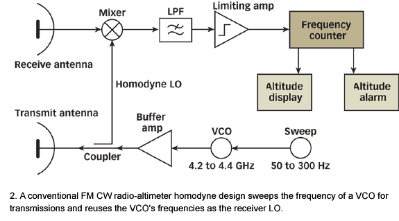
Radio Altimeters may be classified based on their time measurement methods. Basically they are measuring time elapse between transmission and reception of signal. Here is a common diagram; enter image description here

So if we take speed of light as a constant "c", height of the a/c = c * time elapse. Signal transmission and reception time is critical.

Most common radio altimeters works in 4.4 GHz level. Which means every 0.22 nanoseconds it transmits a signal.Can you imagine how many changes need to occur during a normal approach due to terrain changes?

In order to keep things simple and reasonable manufacturers add control units to Altitude Display and Altitude Alert functions. This control units gives you a "window" of altitude you are flying. If you are flying over the sea on a windy day and level of 1000ft. you do not see the effects of waves at your altimeter.

Based on manufacturers tolerance limit +- 10 ft or less is added to prevent over informing pilots.

If you are using pulsing radio altimeters with lower frequencies you will see measurement areas which means you do not measure all the terrain beneath you.There are missing parts but again negligible.

There are many researches going on for more precise radio altimeters especially for unmanned air vehicles. These new types covers more terrain data and maps for proper alerting system.

I believe we keep using those tolerant RAs for a while as airliners.

Cheers,

$\endgroup$
1
  • 8
    $\begingroup$ "Most common radio altimeters works in 4.4 GHz level. Which means every 0.22 nanoseconds it transmits a signal... " I believe this is wrong. 4,4 GHz is the frequency of the transmitted signal, not the PRF. (Pulse Repetition Frequency). It is the PRF that determines the time between pulses, not the signal carrier frequency. Plus, do the math, in 0.22 nanosec, the signal would travel 0.2160576 feet or 2 inches. If the radar was sending pulses that are 2 inches apart, how could it know which transmitted pulse an echo came from? $\endgroup$ Commented Jan 5, 2018 at 16:33

You must log in to answer this question.

Not the answer you're looking for? Browse other questions tagged .