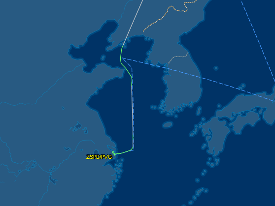
I noticed this a few months ago on a flight to Shanghai. Since then I've been looking on FlightAware occasionally, and every flight I've seen on a similar route has made a turn to the east just before reaching the coast of Shandong. My first thought was noise abatement, but that far out I believe they'd still be at cruise altitude. Any ideas?
-
$\begingroup$ Related: aviation.stackexchange.com/questions/11506/… $\endgroup$– 60levelchangeCommented Aug 5, 2016 at 17:57
-
$\begingroup$ this is not opinion based, we have precedents on this SE: aviation.stackexchange.com/q/13428/1467 $\endgroup$– FedericoCommented Aug 5, 2016 at 20:41
-
$\begingroup$ @Federico Which is why we have the voting system. There are structural differences between these two questions. It is my belief that any answers to this question will be opinion based. So far, I am right. $\endgroup$– SimonCommented Aug 5, 2016 at 21:35
1 Answer
This is a guess, but it may be to avoid the restricted area ZSR-522 that covers airspace just north and east of the Shandong Peninsula. It's hard to say exactly, but it looks like your flight path more or less skirted around it, and the IFR chart suggests that the flight might have followed A326 east and then south from the ANRAT waypoint.
The Chinese AIP says (or said; that link may be out of date) that ZSR-522 is only up to 18000ft so in theory it's still well below typical airliner cruising levels. I've read several times, though, that the Chinese military control their airspace very tightly and they typically don't allow direct flight paths so perhaps they simply insist that aircraft must follow the airways because of 'national security' or some similar reason. Example:
And the military's control of nearly all the airspace between Chinese destinations means that flights within China, even by the favored national carriers, sometimes must fly indirect routes that are the equivalent of going all around the city on a ring road.
-
$\begingroup$ It's great to see that the international IFR charts are available. Most likely we came down on A588 to CHI, and from that point it looks like taking the transition routes through ZSR-522 (W5 and W173) to the west, and just skirting it altogether to the east (A326) are roughly the same distance. $\endgroup$– Tom RCommented Aug 5, 2016 at 21:41

