13
$\begingroup$

Some "ILS or LOC" approaches have crossing restrictions that are shown before and/or after the final approach fix/glideslope intercept.

Are these restrictions for the LOC only approach, or do they also apply when tracking the glideslope?

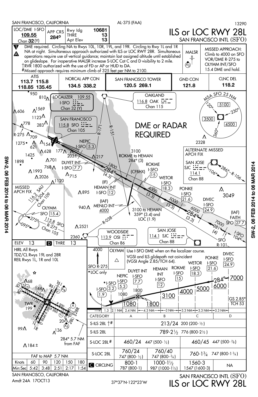
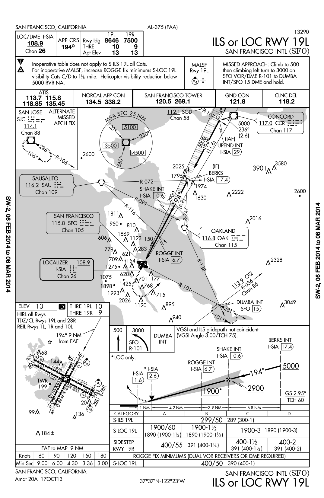
As an example, KSFO ILS 28L and KSFO ILS 19L (see below) both have crossing restrictions before and after glideslope intercept.

For the fixes after intercept though, notice that NEPIC does not have a '*' next to the crossing restriction (which means "LOC only") while ROGGE does:

KSFO ILS 28L

KSFO ILS 19L

$\endgroup$

5 Answers 5

7
+200
$\begingroup$

There are two situations to consider:

  • altitude restrictions before the Final Approach Segment
  • altitude restrictions in the Final Approach Segment

The first case is clear-cut. There is a risk of going outside altitude restrictions if you intercept the glideslope before the published glide slope intercept point, except if noted otherwise. An FAA Information for Operators article states that:

when cleared for an ILS approach, do not descend below published step-down altitudes on an ILS final approach course, while outside the Final Approach Segment.


The main issue now is whether altitude restrictions are enforceable if you are on the glideslope, inside the Final Approach Segment and it does not state that it only applies to LOC approaches.

Throughout the document, it never refers to stepdown fixes inside the Final Approach Segment, often stating that this is referring to "outside the Final Approach Segment".

A note in the AIM (after 5-4-5.b.4) also states that:

The ILS glide slope is intended to be intercepted at the published glide slope intercept altitude. This point marks the PFAF and is depicted by the ”lightning bolt” symbol on U.S. Government charts. Intercepting the glide slope at this altitude marks the beginning of the final approach segment and ensures required obstacle clearance during descent from the glide slope intercept altitude to the lowest published decision altitude for the approach. Interception and tracking of the glide slope prior to the published glide slope interception altitude does not necessarily ensure that minimum, maximum, and/or mandatory altitudes published for any preceding fixes will be complied with during the descent.

To me, this implies that after the published glide slope interception altitude, that it is ensured that these altitudes will be met.

There has also been discussion on another forum about this, though the discussion doesn't provide an authoritative answer to this question.


It seems weird that there is a discrepancy with some approaches having the * past the PFAF, and a few that don't -- I'll take a further look to see if this is just an oversight or actually has specific meaning.

$\endgroup$
4
  • $\begingroup$ Any luck on the *? $\endgroup$
    – Lnafziger
    Commented Apr 26, 2014 at 1:47
  • $\begingroup$ @Lnafziger: nope, but something interesting I found was that on another SFO approach which still has the restriction at NEPIC even though it's an ILS-only approach -- makes me somewhat doubtful about my reasoning, though it would be absurd if the glideslope did not provide adequate clearance. $\endgroup$ Commented Apr 26, 2014 at 8:20
  • 1
    $\begingroup$ I've given you the bounty as you have the best answer so far, but am still looking for an answer to the asterisk bit so haven't accepted it yet. Thanks for all of the effort so far! $\endgroup$
    – Lnafziger
    Commented Apr 26, 2014 at 12:54
  • 2
    $\begingroup$ The ILS 28L at SFO has been revised. Now all of the ILS or LOC approaches there have the * next to each of the stepdown fixes inside the PFAF. The CAT II approach also does not have any required altitudes inside the PFAF, just a reference altitude. $\endgroup$
    – NathanG
    Commented Dec 2, 2015 at 3:15
6
$\begingroup$

Closest regulatory thing I could find :

ICAO Doc 8168 Section 4 Arrival and approach procedures

1.7.5 Any constant descent angle shall clear all stepdown fix minimum crossing altitudes within any segment.

5.2.5.1 A stepdown fix may be incorporated in some non-precision approach procedures

5.5.5.2 The protection area assumes that the pilot does not normally deviate from the centre line more than half-scale deflection [...] more than half course fly-up [...] could place the aircraft in [...] airspace where loss of protection from obstacles can occur.

The writing leads me to believe that a precision approach should not contain stepdown fixes, and that the descent should be a continuous descent from FAP to MAP.

Then again, I could find nothing specific to prevent anyone from inserting an altitude restriction in a precision approach.

I cannot imagine what would be the point of coming down on a constant GS only to level off at 1000' then try to re-capture the GS just two miles from thouchdown. Talk about a stable approach...

$\endgroup$
3
  • $\begingroup$ Confirming your location/altitude on the ILS against the LOC stepdowns might just help one avoid driving the airplane into the ground on a false glideslope. $\endgroup$ Commented Feb 24, 2014 at 16:42
  • $\begingroup$ That's exactly what the chart does, but with the altitudes printed above the GS on the chart in smaller print.It helps prevent false glideslopes, and it gives you a last chance to catch altimeter setting errors. $\endgroup$
    – Radu094
    Commented Feb 24, 2014 at 20:58
  • $\begingroup$ On a side note, during my instrument training a few years ago I did have the advisory/unofficial GS on a LNAV+V approach tell me to go below the authorized LNAV altitude. So, I stopped the descent there, then flew to the next waypoint, then dropped back down to reintercept the advisory GS. I've flown that approach since and it doesn't do that anymore. Possible bad data in that month's approach upload. As far as stable approach, not really a big deal at just 100ish KIAS, but I imagine it would have been exciting in a jet. $\endgroup$ Commented Feb 25, 2014 at 12:39
5
$\begingroup$

At the very beginning of my answer, I would like to remind that everyone should be familiar with the type of charts he is using. A thorough description (PDF) of all charts published by the FAA is available on this FAA website. Refer to page 77 of the PDF document to find the altitudes your question is dealing with. On every flight, you make decisions based on the information you read from those charts.

Basically, once you are cleared for an ILS approach and have intercepted the glidepath in accordance with your clearance, your task is to track the localizer and glideslope, allowing not more than a half-scale deflection, until reaching your DA (or DH on CAT II and III approaches). The exact altitude reading at which the glideslope passes over a specific point is as variable as air density is. This might cause you to be more than 20 feet below the minimum altitudes, but it doesn't matter as all of them past the FAP are for non-precision approaches only.

I don't know how it's handled in the US, also the FAA is using the term FAF - Final Approach Fix - talking about ILS approaches. Technically this is wrong, because the point where you hit the glidepath at a certain altitude is variable - remember the air density. That's why we should talk about a FAP - Final Approach Point.

Anyway, those altitudes should be used when shooting an ILS approach in order to make sure that you didn't fly a side lobe of the glideslope - even if the chances to find one are very remote. On Jeppesen charts you find this 'check altitudes' above the depicted glidepath often at the outer marker (if available) preceeded by the letters GS. On FAA charts these are referred to as recommended altitudes. Find them for example on the chart for the ILS runway 28L approach attached to the question. They are also printed above the glideslope but not underlined, as they are recommended but not mandatory / minimums.

On an ILS approach where you are tracking the localizer, but not the glideslope, because you are too far out and below it, or do not receive it. For example at HEMAN 3100' are important if ATC already cleared you for the approach and you like to descend below the last cleared (maintain xxx feet until established on...) altitude. The latest point where you have to intercept the glide slope is the FAP (FAF according to FAA) but if it is not disagreeing with your clearance you can of course get on glideslope earlier. In this case, prior to the FAP, this minimum altitude is then still mandatory for you (to be at or above) because of reduced glideslope precision at higher distances (it's a cone not a string), but I've never seen someone getting below those minima flying the glide path. In most cases the glideslope will take you quite above these altitudes and you have a continuous and more economic descent into your runway, rather than doing a stepped descent allways being at the minima.

For those who like to take a closer look at Jeppesen's charts, visit their website to find the chart legend (PDF) - take a look at page 55 of this document.
$\endgroup$
4
  • $\begingroup$ While I'm sure that you are correct, the documents that you link to don't specifically address the issue of the step-down fixes and whether or not they are required after glideslope intercept. I'm looking for an actual regulation, AIM reference, or something from the FAA that spells it out... $\endgroup$
    – Lnafziger
    Commented Feb 23, 2014 at 3:48
  • $\begingroup$ Also, can you explain the * next to the minimum altitude at ROGGE (meaning "LOC only") and the lack of one at NEPIC? This is inconsistent and leads me to believe that there is a difference. $\endgroup$
    – Lnafziger
    Commented Feb 24, 2014 at 4:55
  • $\begingroup$ NEPIC at 1080 can be used as a check altitude when established on the ILS where ROGGE at 1900 can not. The * whith it's remark should height it. That's the way I interpret this as someone who doesn't use FAA charts. $\endgroup$
    – Falk
    Commented Feb 24, 2014 at 16:04
  • 1
    $\begingroup$ The alt check at NEPIC is already printed above GS. Logic would dictate that they need to print a * near the bigger 1080 under the GS to suggest that stepdown is "LOC only" $\endgroup$
    – Radu094
    Commented Feb 24, 2014 at 21:01
1
$\begingroup$

The asterisk informs the pilot that this only applies to the Non-Precision LOC approach. The bolded V is indicating this is a Visual Decision Point (VPD). See Aeronatical Charts Users Guide.

On some IAPs the decent rate required to reach the minimum decent altitude (MDA) by the missed approach point (MAP) at a distance from the threshold that will allow landing in the touchdown zone will be informed by a VDP. See Descent Rates and Glide Paths for Non-Precision Approachs in the Instrument Procedures Handbook in Chapter 4 (4-37 in 2012) for a discussion of the corresponding math.

In short when on the 19L ILS/LOC between SHAKE and ROGGE you either be above 1900 or on glideslope for obstacle clearance. Interestingly if you look at the VFR Sectional and plot that approach you'll see that this portion is over the water but in the departure for 30 28l and 28R for OAK.

$\endgroup$
1
$\begingroup$

Think of it this way ... Before the published glideslope interception point (lightning bolt symbol) we must respect all published crossing altitudes even in receiving a glideslope signal. Once inside the published glideslope interception point the glideslope becomes the primary vertical navigation. Published altitudes inside the glideslope intercept point are there to provide stepdown fixes in the event the GS is inop.

Often we can follow a glideslope before reaching the published intercept point and it will not bust any published crossing altitudes, but this is not always the case. The ILS 24 approaches into LAX are an example (or at least used to be.. I've not flown them for a couple of years now). One could intercept the localizer 30 miles out and get a good stable GS signal but if you followed the GS it would clip the minimum crossing altitudes by a couple of hundred feet. We had enough pilots doing this that ATC asked us to pass the word to all pilots at the airline to pay attention to the minimum crossing altitudes.

Unfortunately this is not all clearly laid out anywhere I have found, (AIM, TERPS, FOM, etc) - the above comments are based on experience...

$\endgroup$

You must log in to answer this question.

Not the answer you're looking for? Browse other questions tagged .