2
$\begingroup$

I'm going to use couple examples to ask my question:

Looking at KBVY chart supplement, it says:

enter image description here

RADIO AIDS TO NAVIGATION: NOTAM FILE LWM.
  LAWRENCE (L) DME 112.5 LWM Chan 72 N42°44.43 ́ W71°05.69 ́ 140° 12.3 NM to fld. 306/0W.
  DME unusable:
    160°–195° byd 23 NM blo 2,500 ́

Looking at KMLT chart supplement, it says:

enter image description here

RADIO AIDS TO NAVIGATION: NOTAM FILE MLT.
  (H) (H) VOR/DME 117.9 MLT Chan 126 N45°35.20 ́ W68°30.93 ́ 317° 8.0 NM to fld. 553/20W.
  DME unusable:
    330°–350° byd 35 NM blo 6,000 ́
  VOR portion unusable:
    330°–340° byd 35 NM blo 6,000 ́

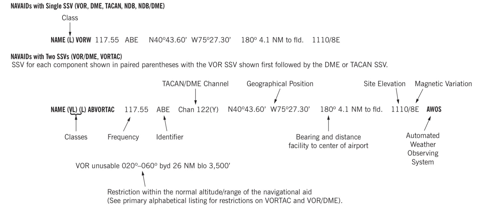
Referring to FAA Chart Supplement guide:

enter image description here

KBVY is 12.3 NM from KWM-DME on the bearing of 140°. What does 0w variation mean? KMLT is 8.0 NM from MLT VOR on the bearing of 317°. What does 20W variation mean?

KBVY is close to the middle of 14°W and 15°W isogonic lines, and KMLT is somewhere between 16°W and 16°30'W isogonic lines, closer to 16°.

I know what magnetic variation is, and how to use it to convert true course to magnetic course. What I don't understand is what is it implying here, in the context of chart supplement, and how one would use it, for what purpose?

It clearly doesn't correlate with the isogonic lines in that area, and the bearings given are magnetic so they shouldn't need conversion (see here: What are the units for the bearing to center of an airport from radio aids to navigation in chart supplement?).

$\endgroup$
2
  • 1
    $\begingroup$ In order to fly from the MLT VOR station you would use the MLT 317 radial. However, mag north has shifted (about 4 degrees - 16W now vs 20W then ) since the MLT VOR was installed (about 1965). As a result you would (in a no wind condition) have to fly a mag course of 313 degrees (4 degrees different) to track on the 317 radial instead of a mag course of 317 (which would have been the mag course when MLT was first installed). The radial does not change with a mag north shift, just the mag course needed to track on it. @randomhead and I have some comments below that may help. $\endgroup$
    – user22445
    Commented Jul 28, 2022 at 20:23
  • $\begingroup$ Your comment below the answer from @randomhead -"317-20=296 is the radial I want to fly from MLT. Is that correct?" is not correct. From MLT VOR you would still fly the 317 radial. See my comment above. $\endgroup$
    – user22445
    Commented Jul 29, 2022 at 15:40

1 Answer 1

7
$\begingroup$

Conceptually, VORs (and VORTACs) emit radials which are fixed lines radiating out from the VOR. One of those radials is designated "north" (0º, 360º) and all of the other radials are designated based on their relative position from that "north" radial.

The decision as to which radial is called "north" is 1) completely arbitrary, from a technical standpoint, and 2) unvarying, from a technical standpoint.

Therefore the "north" radial is chosen so that, at the time of installation, it is the radial which points directly to magnetic north. If, at the time of installation, you start at the VOR and follow your magnetic compass "due north," you are walking along the 360º radial of the VOR. The difference between magnetic north and true north is magnetic variation, as you know and expect, but this is not relevant at the moment of installation.

However, the Earth's magnetic poles shift over time. Here is the answer to your question: The radials of a VOR do not shift over time. If you return to the same VOR forty years later, the 360º radial will still be pointing the exact same direction it was when it was installed. But if you follow your magnetic compass "due north" you will no longer be walking along that 360º radial. That is why the variation listed for a VOR does not match what you would expect from the current isogonic lines.

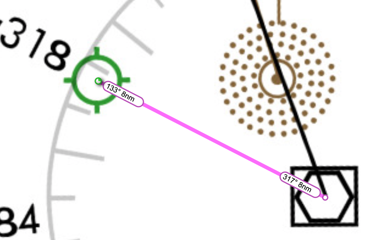
The discussion is further confused because Skyvector, at least, assumes that when you are flying outbound from a VOR you are likely to be navigating using a radial off that VOR—and it silently provides you with a radial instead of a bearing. For example, if you enter into Skyvector the route KMLT..MLT..KMLT it tells you that you would fly a 133º track to go from the airport to the VOR, but on your return you could fly the 317º radial to get to the airport, rather telling you to fly a 313º bearing. (Note that the current variation is 16ºW while the variation for the NAVAID is 20ºW—thus a 4º difference between radial and bearing.) This certainly tripped me up when I was trying to confirm what I said above.

Screenshot of Skyvector showing the Enroute L-32 chart and a route (in magenta) going from Millinocket Airport to Millinocket VOR-DME and back. From the airport to the VOR is a label showing "133º 8NM" and from the VOR back to the airport is a label showing "317º 8NM."

Note that DME stations do not emit radials. Instead they only tell you your distance to the station but nothing about your bearing. As such they cannot be said to have any variation at all; this is depicted in the Chart Supplement as zero variation, although the correct term would probably be "null" or "not applicable."

$\endgroup$
7
  • $\begingroup$ Thanks @randomhead. Just to make sure I understand this: since LWM is DME only, if I get an old wet compass over LWM and fly the 140° magnetic heading, I’ll get to KBVY. I can do the same thing over MLT with a wet compass, or if I want to use the VOR, I’d have to apply 20W correction to VOR radial: 317-20=296 is the radial I want to fly from MLT. Is that correct? $\endgroup$ Commented Jul 28, 2022 at 1:45
  • 1
    $\begingroup$ Sounds about right, but for two things: 1. Skyvector says that LWM to BVY is a 154º magnetic bearing, not 140º (remember the 14º variation is the difference between true and magnetic; you have a magnetic compass so when Skyvector gives the magnetic bearing you don't need to adjust further). And 2. You want to compare the NAVAID variation with the current isogonic line; looking at MLT you would expect to need only a 4º correction, not the full 20º. Although strangely enough Skyvector shows a 317º magnetic bearing from the VOR to the airport, which seems to line up with the actual 317º radial. $\endgroup$
    – randomhead
    Commented Jul 28, 2022 at 3:11
  • 1
    $\begingroup$ @757, if MLT was installed when the variation was 20° and the current variation is 16° then why does flying the MLT 317° radial make you track 317° magnetic bearing? I would expect a 4° difference. That's what I'm confused about. $\endgroup$
    – randomhead
    Commented Jul 28, 2022 at 11:33
  • 1
    $\begingroup$ My comment was written to correct the OP's comment about having to fly the 296 radial. In doing so I just meant to say the that he/she should fly the 317 radial as shown. But I added some confusion in my terminology. The mag compass course to track (no wind) on the 317 radial would be 4 degrees different than it was when the vor was originally set (in 1965 ) since mag north has shifted (20w variation vs 16w variation). This comment should be clearer. Deleting my previous comment. $\endgroup$
    – user22445
    Commented Jul 28, 2022 at 14:11
  • 1
    $\begingroup$ PATTA is on the MLT 318 radial and is "bearing" 318 degrees from the MLT VOR. The actual track along the ground of the 318 radial is the same as it was in 1965. However, unlike in 1965 when your mag compass (no wind/deviation) would show 318 degrees mag when tracking along the 318 radial, today it would read 314 degrees (4 degree shift in mag north). Same with the Chart Sup showing 317 degree bearing (8 nm) to the field. That's based on 20w var. MLT will still be a 317 bearing from the field, you would just fly a no wind mag course of 313 to track the 317 radial. That's my understanding. $\endgroup$
    – user22445
    Commented Jul 28, 2022 at 18:06

You must log in to answer this question.

Not the answer you're looking for? Browse other questions tagged .