add clarification about skyvector
Source Link
randomhead
  • 17k
  • 1
  • 46
  • 87

Conceptually, VORs (and VORTACs) emit radials which are fixed lines radiating out from the VOR. One of those radials is designated "north" (0º, 360º) and all of the other radials are designated based on their relative position from that "north" radial.

The decision as to which radial is called "north" is 1) completely arbitrary, from a technical standpoint, and 2) unvarying, from a technical standpoint.

Therefore the "north" radial is chosen so that, at the time of installation, it is the radial which points directly to magnetic north. If, at the time of installation, you start at the VOR and follow your magnetic compass "due north," you are walking along the 360º radial of the VOR. The difference between magnetic north and true north is magnetic variation, as you know and expect, but this is not relevant at the moment of installation.

However, the Earth's magnetic poles shift over time. Here is the answer to your question: The radials of a VOR do not shift over time. If you return to the same VOR forty years later, the 360º radial will still be pointing the exact same direction it was when it was installed. But if you follow your magnetic compass "due north" you will no longer be walking along that 360º radial. That is why the variation listed for a VOR does not match what you would expect from the current isogonic lines.

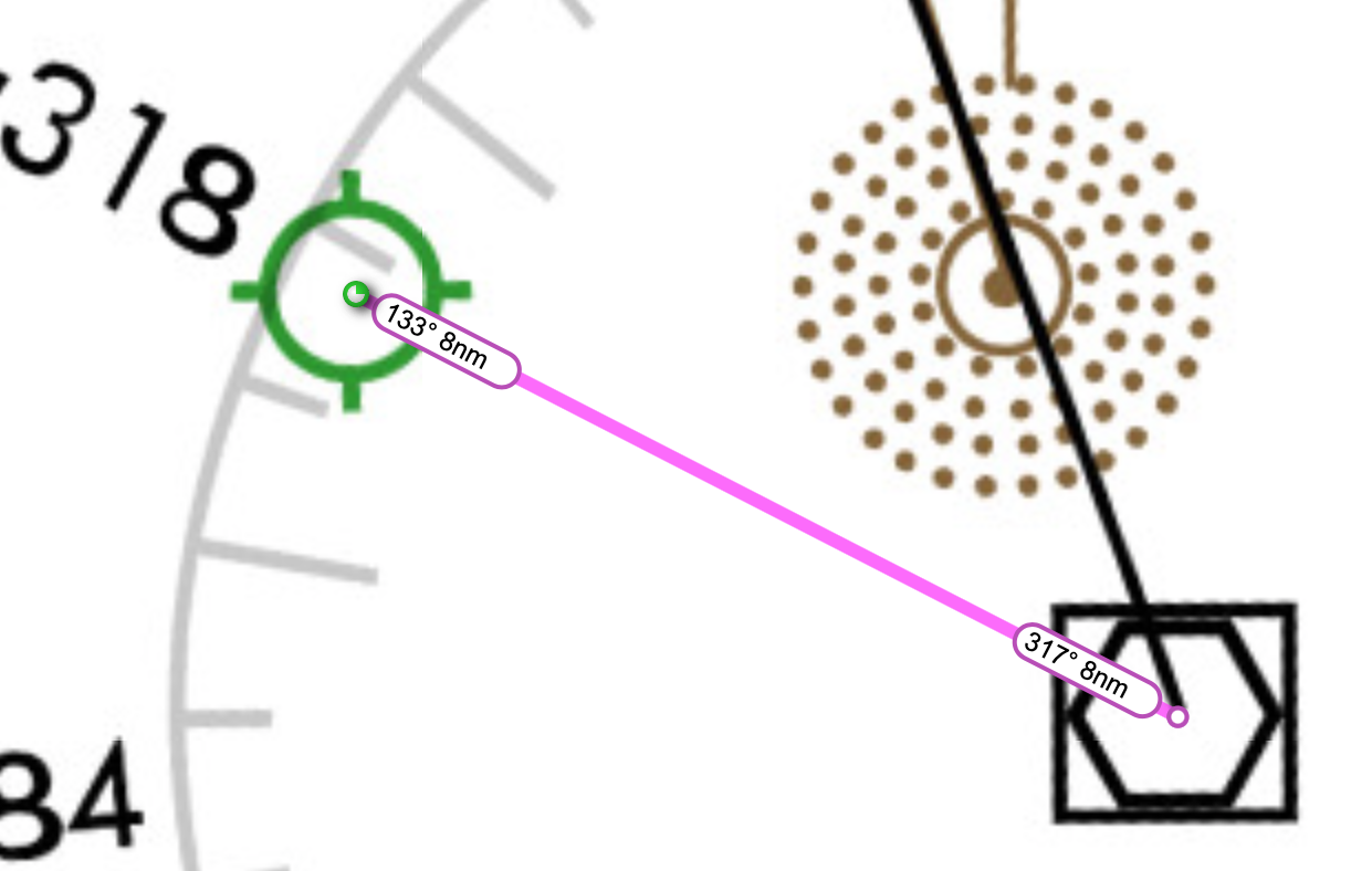
The discussion is further confused because Skyvector, at least, assumes that when you are flying outbound from a VOR you are likely to be navigating using a radial off that VOR—and it silently provides you with a radial instead of a bearing. For example, if you enter into Skyvector the route KMLT..MLT..KMLT it tells you that you would fly a 133º track to go from the airport to the VOR, but on your return you could fly the 317º radial to get to the airport, rather telling you to fly a 313º bearing. (Note that the current variation is 16ºW while the variation for the NAVAID is 20ºW—thus a 4º difference between radial and bearing.) This certainly tripped me up when I was trying to confirm what I said above.

Screenshot of Skyvector showing the Enroute L-32 chart and a route (in magenta) going from Millinocket Airport to Millinocket VOR-DME and back. From the airport to the VOR is a label showing "133º 8NM" and from the VOR back to the airport is a label showing "317º 8NM."

Note that DME stations do not emit radials. Instead they only tell you your distance to the station but nothing about your bearing. As such they cannot be said to have any variation at all; this is depicted in the Chart Supplement as zero variation, although the correct term would probably be "null" or "not applicable."

Conceptually, VORs (and VORTACs) emit radials which are fixed lines radiating out from the VOR. One of those radials is designated "north" (0º, 360º) and all of the other radials are designated based on their relative position from that "north" radial.

The decision as to which radial is called "north" is 1) completely arbitrary, from a technical standpoint, and 2) unvarying, from a technical standpoint.

Therefore the "north" radial is chosen so that, at the time of installation, it is the radial which points directly to magnetic north. If, at the time of installation, you start at the VOR and follow your magnetic compass "due north," you are walking along the 360º radial of the VOR. The difference between magnetic north and true north is magnetic variation, as you know and expect.

However, the Earth's magnetic poles shift over time. Here is the answer to your question: The radials of a VOR do not shift over time. If you return to the same VOR forty years later, the 360º radial will still be pointing the exact same direction it was when it was installed. But if you follow your magnetic compass "due north" you will no longer be walking along that 360º radial. That is why the variation listed for a VOR does not match what you would expect from the current isogonic lines.

Note that DME stations do not emit radials. Instead they only tell you your distance to the station but nothing about your bearing. As such they cannot be said to have any variation at all; this is depicted in the Chart Supplement as zero variation, although the correct term would probably be "null" or "not applicable."

Conceptually, VORs (and VORTACs) emit radials which are fixed lines radiating out from the VOR. One of those radials is designated "north" (0º, 360º) and all of the other radials are designated based on their relative position from that "north" radial.

The decision as to which radial is called "north" is 1) completely arbitrary, from a technical standpoint, and 2) unvarying, from a technical standpoint.

Therefore the "north" radial is chosen so that, at the time of installation, it is the radial which points directly to magnetic north. If, at the time of installation, you start at the VOR and follow your magnetic compass "due north," you are walking along the 360º radial of the VOR. The difference between magnetic north and true north is magnetic variation, as you know and expect, but this is not relevant at the moment of installation.

However, the Earth's magnetic poles shift over time. Here is the answer to your question: The radials of a VOR do not shift over time. If you return to the same VOR forty years later, the 360º radial will still be pointing the exact same direction it was when it was installed. But if you follow your magnetic compass "due north" you will no longer be walking along that 360º radial. That is why the variation listed for a VOR does not match what you would expect from the current isogonic lines.

The discussion is further confused because Skyvector, at least, assumes that when you are flying outbound from a VOR you are likely to be navigating using a radial off that VOR—and it silently provides you with a radial instead of a bearing. For example, if you enter into Skyvector the route KMLT..MLT..KMLT it tells you that you would fly a 133º track to go from the airport to the VOR, but on your return you could fly the 317º radial to get to the airport, rather telling you to fly a 313º bearing. (Note that the current variation is 16ºW while the variation for the NAVAID is 20ºW—thus a 4º difference between radial and bearing.) This certainly tripped me up when I was trying to confirm what I said above.

Screenshot of Skyvector showing the Enroute L-32 chart and a route (in magenta) going from Millinocket Airport to Millinocket VOR-DME and back. From the airport to the VOR is a label showing "133º 8NM" and from the VOR back to the airport is a label showing "317º 8NM."

Note that DME stations do not emit radials. Instead they only tell you your distance to the station but nothing about your bearing. As such they cannot be said to have any variation at all; this is depicted in the Chart Supplement as zero variation, although the correct term would probably be "null" or "not applicable."

Source Link
randomhead
  • 17k
  • 1
  • 46
  • 87

Conceptually, VORs (and VORTACs) emit radials which are fixed lines radiating out from the VOR. One of those radials is designated "north" (0º, 360º) and all of the other radials are designated based on their relative position from that "north" radial.

The decision as to which radial is called "north" is 1) completely arbitrary, from a technical standpoint, and 2) unvarying, from a technical standpoint.

Therefore the "north" radial is chosen so that, at the time of installation, it is the radial which points directly to magnetic north. If, at the time of installation, you start at the VOR and follow your magnetic compass "due north," you are walking along the 360º radial of the VOR. The difference between magnetic north and true north is magnetic variation, as you know and expect.

However, the Earth's magnetic poles shift over time. Here is the answer to your question: The radials of a VOR do not shift over time. If you return to the same VOR forty years later, the 360º radial will still be pointing the exact same direction it was when it was installed. But if you follow your magnetic compass "due north" you will no longer be walking along that 360º radial. That is why the variation listed for a VOR does not match what you would expect from the current isogonic lines.

Note that DME stations do not emit radials. Instead they only tell you your distance to the station but nothing about your bearing. As such they cannot be said to have any variation at all; this is depicted in the Chart Supplement as zero variation, although the correct term would probably be "null" or "not applicable."