1
$\begingroup$

I have a question perhaps best demonstrated with this image:
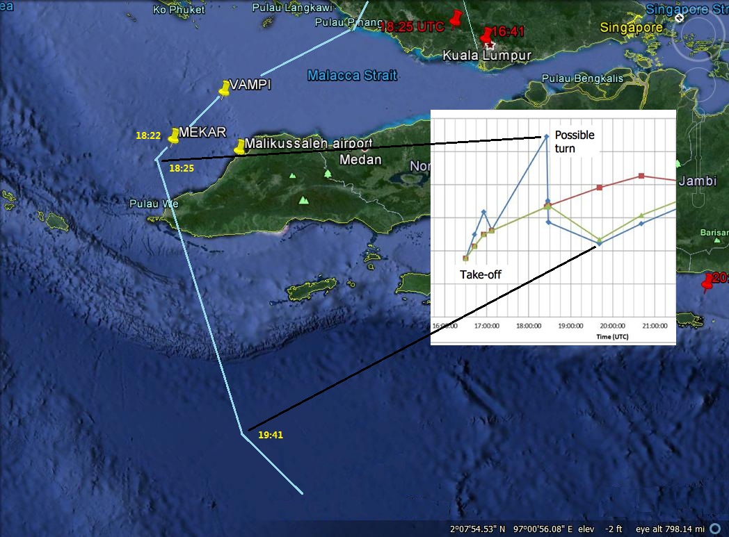
Malacca Flight Track

Malaysia published two maps with the preliminary accident report which allege MH370 flew west from Penang to MEKAR (above Aceh Province) and then between 18:25 UTC and 19:41 UTC flew west into the Indian Ocean.

The problem is the Burst Offset Frequency chart published 24 March shows a frequency drop after 18:25 UTC signifying flight away from the satellite.

After MH370 allegedly emerged from the Straits and turned south the track which Malaysia's Preliminary Accident Report claims MH370 flew (based on their analysis of the BOF chart data) the track makes even less sense because the distances away from the satellite continue to increase.
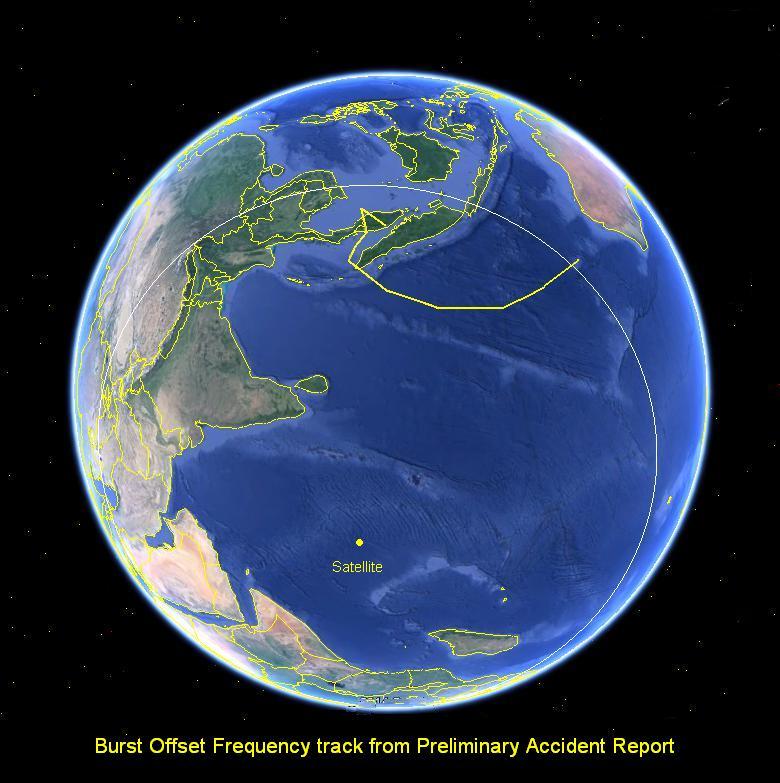
BOF track + Satellite position

And this image shows the distance relationship with the satellite:
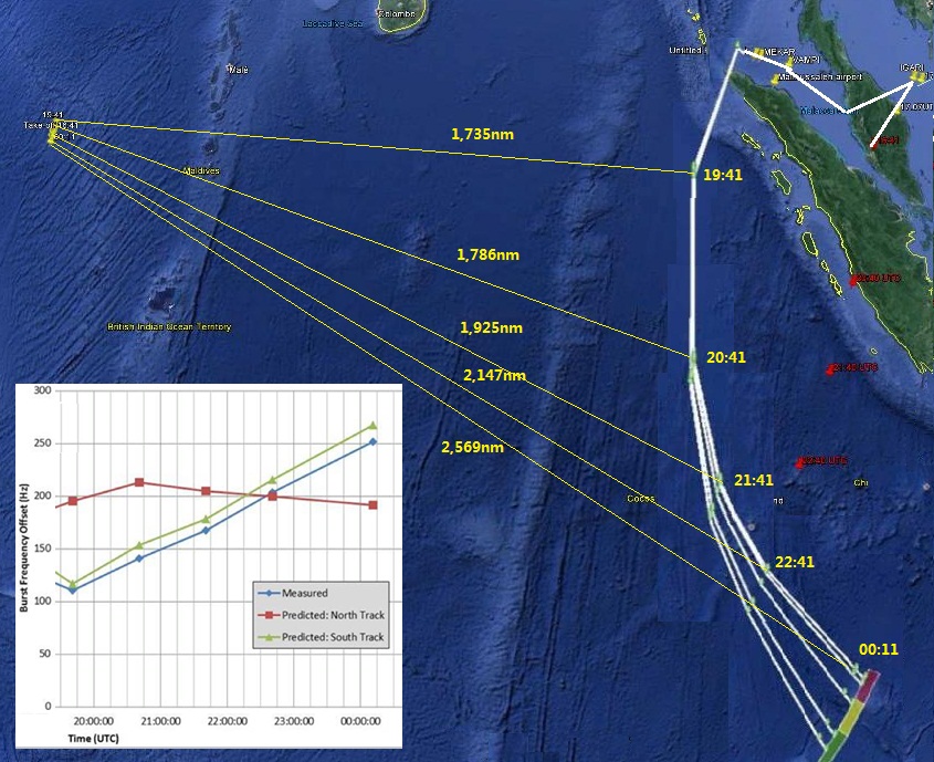
Track displacement from satellite

There are also other (non satellite) reasons to question the validity of the alleged track through the Straits of Malacca. First is the claim MH370 was seen flying west by radar at Surat Thani in Thailand. That radar has a published maximum range of 200nm. Kota Bharu is 240nm away from Surat Thani.
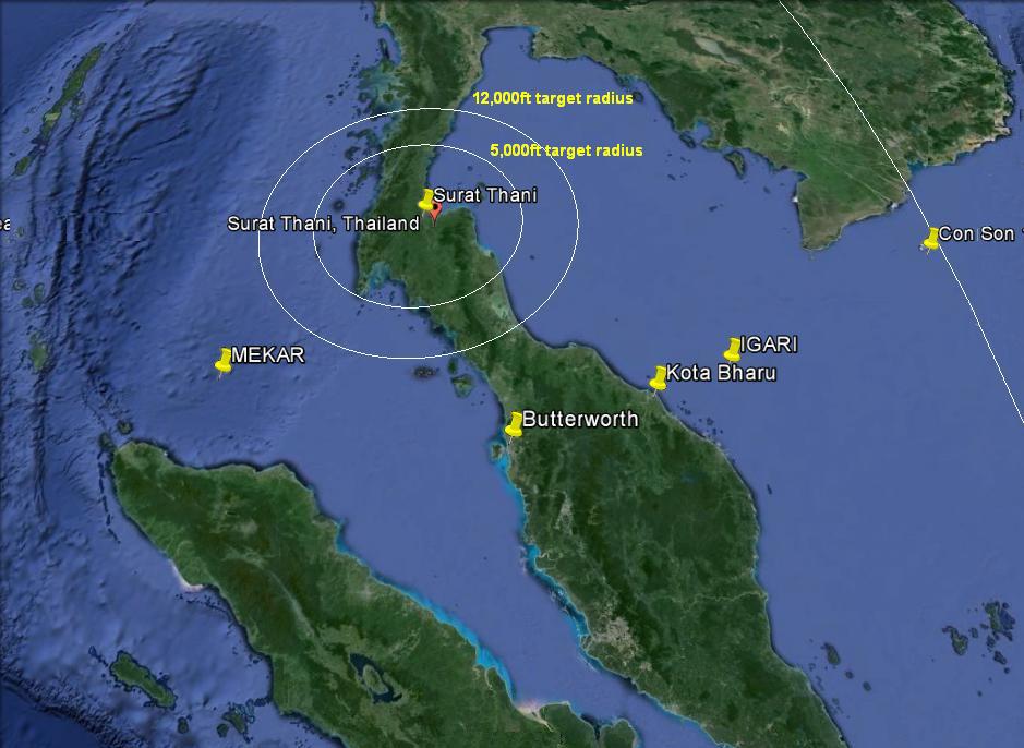
Surat Thani radar radius 92nm & 140nm

This is not the only reason to doubt the alleged MH370 flight though the Straits. Malaysia presented this image to Chinese relatives at the Lido hotel in Beijing on 21 March and told them it was a military radar image from Butterworth of MH370 in the Straits of Malacca. They said it crossed the island of Pelau Perak at 18:02 UTC and disappeared at 18:22 UTC.
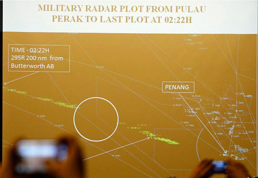
Lido Hotel image

The image however omits other aircraft known to be present at the same time:
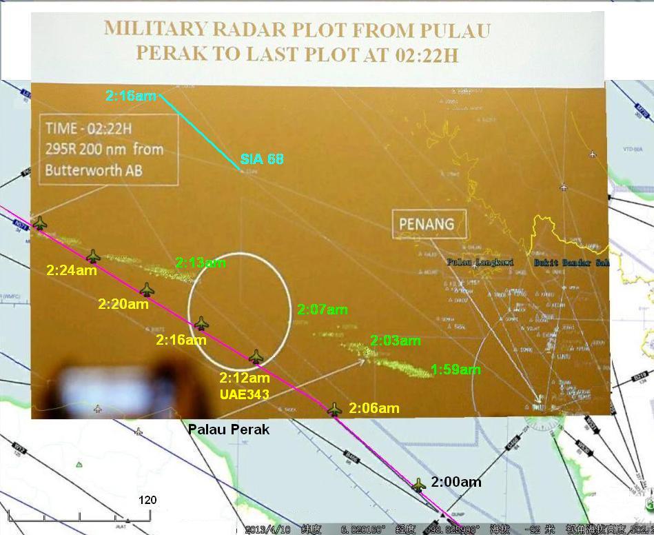
UAE343 overlay

Worst inconsistency of all however is this, the radar image does not even come from the Butterworth radar. The real military radar used by Butterworth is a Thales Raytheon GM400 which has a screen display like this:
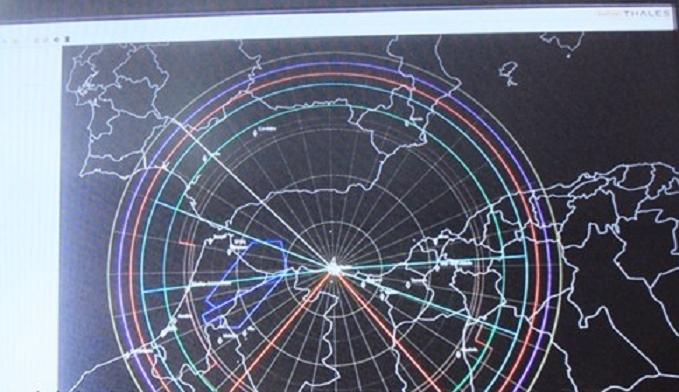
Thales Raytheon GM400

I don't understand how so many supposedly intelligent "experts" and journalists have managed to be deceived for so long except to say people believe only what they want to believe and shut their eyes to the truth.

Australian, Malaysian, Japanese, New Zealand and Chinese taxpayers collectively forked out $90m wasted taxpayer dollars for a search at the end of this projected BOF track in April which turned up no result.

My question is how does this mutually incompatible information prove MH370 flew west through the Straits at all?

$\endgroup$
12
  • $\begingroup$ Could you possibly include the position of the satellite at 18:25 as well as the angle that it was pointed at. It's hard to understand what you mean without knowing the location of the satellite and the angle it was at when the data was gathered. $\endgroup$
    – Jae Carr
    Commented May 15, 2014 at 23:16
  • $\begingroup$ Why do you say that the data is mutually incompatible? Why could MH370 not be flying away from the satellite and be flying west? $\endgroup$
    – user2168
    Commented May 15, 2014 at 23:40
  • $\begingroup$ Jay the satellite distances actually reduce by 5 nautical miles yet the BOF chart has the satellite receding away at speed. $\endgroup$
    – user2357
    Commented May 16, 2014 at 1:04
  • $\begingroup$ Articuno it is incompatible for the satellite handshakes to be moving apart when investigators claim MH370 was flying towards the satellite. I can't explain it any clearer than that. $\endgroup$
    – user2357
    Commented May 16, 2014 at 1:07
  • $\begingroup$ @user2357 You say that the satellite pings "went east", but I don't see that in the chart. What is the vertical axis in the chart? East-west? Or is it distance from the satellite? Why couldn't the pings be getting farther from the satellite and MH370 be moving westward. I don't see the contradiction that you're claiming. $\endgroup$
    – user2168
    Commented May 16, 2014 at 3:33

1 Answer 1

7
$\begingroup$

You have an error in one of your major premises.

You say "satellite pings went east".

That can't be derived from the data you have shown. The chart is showing Doppler shift. A westbound aircraft that is decelerating, or simply decreasing its component of velocity toward the satellite (by, for example, turning slightly southbound) will result in a change in the Doppler shift.

Deviations up and down on that chart don't correspond to the velocity being east or westbound, but accelerations towards or away from the satellite.

$\endgroup$
11
  • 1
    $\begingroup$ Doppler shift is proportional to relative velocity, not acceleration. $\endgroup$
    – Jan Hudec
    Commented May 16, 2014 at 19:03
  • 2
    $\begingroup$ But changes in the doppler shift (relative velocity) would be caused by acceleration. That was what I was trying to say. $\endgroup$
    – user2168
    Commented May 16, 2014 at 19:05
  • $\begingroup$ A Doppler shift is a reflection of signal compression (towards INMARSAT) or expansion (away from INMARSAT). Where the frequency is increasing there has to be a net closure of distance westwards. $\endgroup$
    – user2357
    Commented Jun 19, 2014 at 5:19
  • 1
    $\begingroup$ @user2357 That is false. When the frequency is increasing there has only to be a net acceleration towards the satellite, not necessarily a closure of distance westwards. $\endgroup$
    – user2168
    Commented Jun 19, 2014 at 5:30
  • 1
    $\begingroup$ @user2357 Deceleration is acceleration. If you're heading west and slowing down, you're accelerating eastward. If you're heading east and slowing down, you're accelerating westward. $\endgroup$
    – user2168
    Commented Jun 19, 2014 at 21:33

Not the answer you're looking for? Browse other questions tagged .