8
$\begingroup$

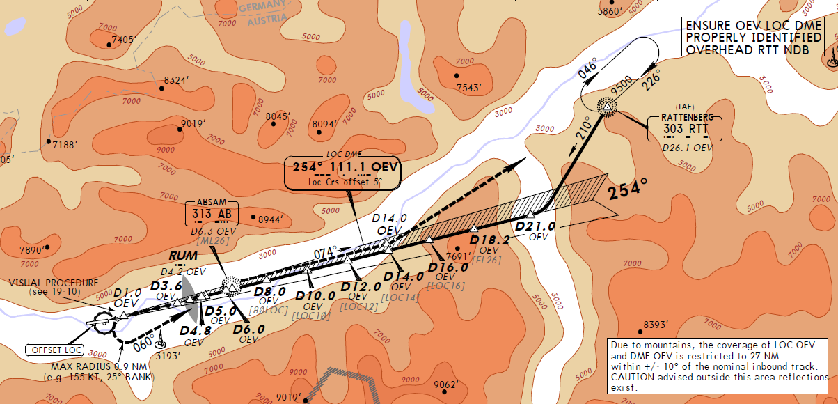
When approaching Innsbruck (ICAO: LOWI) from the east, you intercept a localizer (111.10) which also provides glide slope indication. I believe this should be used just for guidance and not for A/P controlled descent.

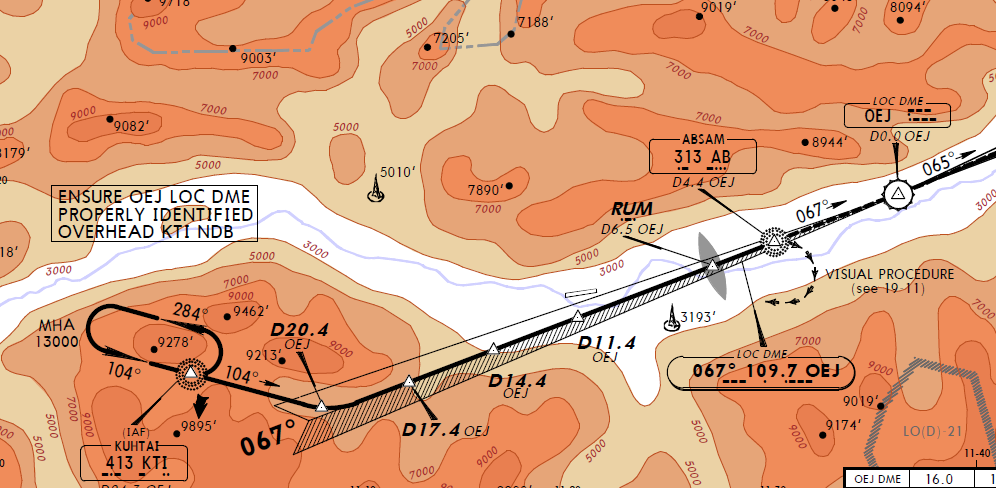
Making the western approach, you intercept another localizer (109.70) that guides you in the right direction before making the final circling procedures towards the runway. However, this one has no glide slope guidance, and you have to manually compare the current altitude and DME values to the ones in the profile given in the charts (excerpt below) and correct the descent accordingly.

I'm wondering why this is. The descent in the western approach is by no means easier than when coming from the east, see images below.

The approaches differ somewhat in that the eastern localizer gives guidance all the way to runway 26, albeit offset by 5 degrees, but the western localizer is placed far from the airport and is used to get to the start of the circling procedures to either runway.

Could this be the reason that glide slope guidance is omitted, or are there other reasons not to provide this support in the western approach?

Update: I would like to expand and clarify this question to give it a more general touch. Are there regulations that control the appropriateness of g/s equipment when it comes to the particulars of the terrain or the vicinity to the runway? Are there other properties (geographical or other) that would limit its usability?

Eastern approach profile

enter image description here

Western approach profile

enter image description here

$\endgroup$

1 Answer 1

7
$\begingroup$

Looking at the charts, I can see quite a few good reasons for not providing glideslope for the West approach:

  1. The East approach leads you (almost) directly to the runway threshold, the West approach leads you a few miles east of the airport.
  2. The East approach has more terrain clearance. If you go only slightly below the glideslope for the West approach, you will be dangerously close to terrain.
  3. The descent profile is steeper for the West approach: you are expected to lose 1500 feet for every 3 miles you travel. For the East approach it's 1320 feet for every 3 miles.

Number 1 is very important. If some pilot decides to blindly follow the ILS needle on a East approach, eventually he'll see the runway. If a pilot does the same on a West approach, eventually he'll crash his plane somewhere in the valley. The absence of glideslope reminds the pilot he has to pay attention to the vertical space.

Tracking the glideslope accurately is also pointless, as the pilot will transition to a visual approach and circle around anyway. It won't make big difference if you were a little bit off the initial descent.


For reference, East approach: enter image description here

West approach: enter image description here

$\endgroup$
3
  • 3
    $\begingroup$ In addition there are mountains on the west, closer than on the other side, they likely reflect the beams. I don't know if ICAO has related restriction for a GS design. $\endgroup$
    – mins
    Commented Dec 11, 2015 at 21:32
  • $\begingroup$ Thanks, this sounds reasonable. Do you have any references to any of your claims? It would be interesting to know if there are regulatory reasons, and I will update my question to clarify. $\endgroup$
    – Daniel R
    Commented Dec 12, 2015 at 14:00
  • $\begingroup$ Also the glideslope almost certainly does not pass through where the localizer transmitter is installed, so it would have to be installed somewhere else. $\endgroup$
    – Jan Hudec
    Commented Jul 8, 2016 at 19:15

You must log in to answer this question.

Not the answer you're looking for? Browse other questions tagged .