31
$\begingroup$

I use FlightRadar24 on my iPad to track friends'/family's flights when they are traveling (not paranoia, just curious). I've noticed that, quite often, their plane will jump from one location to another, or jump backwards down the flight path, or zoom forward, or any other number of motions that I assume the plane isn't actually making. (My personal favorite being when they miss the runway on touchdown and the plane disappears. If that actually happened as often as Flight Radar 24 made it look like it was happening...)

What makes the planes do this on FlightRadar24? Why can't it just track the planes correctly?

$\endgroup$

4 Answers 4

38
$\begingroup$

FR24 relies for most of the tracks on ADS-B data. Part of the ADS-B transmissions is the position. There are three causes of the behaviour that you observe:

1). Aircraft landing next to the runway

The position source onboard the aircraft is not always GPS. Mainly older aircraft (e.g. Fokker 100) have their Inertial Navigation System (INS) coupled to the ADS-B transmitter. The INS relies not on external radio measurements but only on measured acceleration and rotation to track its position. It is usually correct at take-off, but it develops biases over time and therefore the landing appears quite often next to the runway. I can assure you that this is mostly misleading.

2). Short time track offset

In most aircraft the ADS-B position is from GPS. When the GPS loses its position fix, the system falls back to INS. As described above, the INS position is slowing drifting from the truth during the flight, so the ADS-B track will shortly jump aside to the INS position until the GPS comes back. When short (e.g. 1 position update) the offsets appear as spikes.
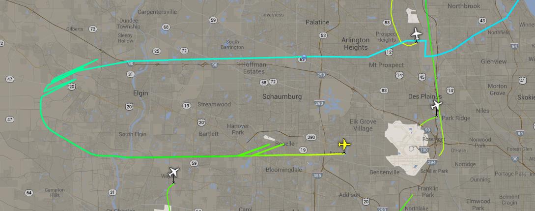
INS jump

3). Long distance jumps (180 NM, 360 NM)

Due to the limited number of bits available in the ADS-B messages, position is encoded in a complex format called Compact Position Reporting. It requires at least two position messages to decode the first position of a track, from that point onward, every message will constitute a position update. When no proper verification algorithms are used in the software, it may occur that a receiver station initializes the track wrongly, usually causing a jump of 180 or 360 NM.

Also note: When INS is used a the position source, the ADS-B data contains an indication that the data is not to be trusted, but that is silently ignored by FR24.


For aircraft that do not transmit their position over ADS-B, but have a Mode-S transponder on-board, FR24 multilaterates their position. This is a process relying on the difference in travel time of the radio signal from the transponder to several receivers. Based on the time difference of arrival of the same transmission at various location, the position of the transmitter can be calculated. This works only if three or more receiver receive the signal.

Since radio waves, as a form of electromagnetic radiation like light, travel at the speed of light, the clocks in the receivers have to very precisely synchronised to determine the difference in arrival time of the signal. A microsecond deviation can already cause a position error of several hundreds of meters. Due to this, Multilateration tracks in FR24 are often a bit jagged.

$\endgroup$
6
  • $\begingroup$ Could you possibly edit the question to explain what an Inertial Navigation System actually is? I'm not sure why it would be so different from GPS. $\endgroup$
    – Jae Carr
    Commented Mar 14, 2014 at 14:26
  • $\begingroup$ @JayCarr INS is topic on itself, quite complicated. Instead of relying on radio signals like GPS, it relies on measuring accelerations and rotations to keep track of position. Feel free to ask another question and I am sure someone can provide a good explanation. (or else I'll try) $\endgroup$
    – DeltaLima
    Commented Mar 14, 2014 at 14:30
  • $\begingroup$ Oh, I probably will. I was more hoping for that one line answer that you put in your reply right there. Just a primer for people (like me) who have no clue what-so-ever and want a one line clarifier. $\endgroup$
    – Jae Carr
    Commented Mar 14, 2014 at 14:32
  • $\begingroup$ @DeltaLima - Excellent, exactly what I was looking for on INS (for this answer). $\endgroup$
    – Jae Carr
    Commented Mar 14, 2014 at 14:38
  • 1
    $\begingroup$ An additional reason: sometimes the aircraft will pass out of ADS-B range, as it relies on receivers on the ground. This tends not to happen over Europe much, and the USA is pretty good, but around Africa then the lack of or spotty signal can make strange things appear to happen. $\endgroup$
    – Jon Story
    Commented Feb 9, 2015 at 17:35
19
$\begingroup$

Not to take away from already great answer provided. In my experience the jumping behavior you are describing in Flightradar24 is due to MLAT triangulation that is used to establish approximate location rather than absolute (using GPS).

Older planes transmit a SUBSET of ads-b data, which does not include aircraft location. So FR24 knows that there is an aircraft in the air, but doesn't know its location. This is where multilateration (triangulation really) comes into play.

If you have a few (minimum of 4) receivers available AROUND the aircraft that are tuned precisely to the same clock, you can measure how long that same ads-b signal reaches all 4 receivers from which approximate location can be determined.

In FR24 you can verify which of the "jumpy" planes are being tracked by MLAT setup by looking at "radar" that is tracking it. If MLAT is used you will see "T-MLAT" as the source.

If you indeed see jumpy behavior on the planes that are tracked by "T-###" or "F-###" sources then I would agree with already posted answer by DeltaLima

$\endgroup$
2
  • 1
    $\begingroup$ Sometimes I wish we could combine answers on this site, just so that if two people have parts of the answer I could mark both as correct... $\endgroup$
    – Jae Carr
    Commented Mar 18, 2014 at 13:36
  • 1
    $\begingroup$ No worries Jay, it's all about learning, we are all learning from all these different answers, that's what this community is about! $\endgroup$
    – KORD4me
    Commented Mar 18, 2014 at 13:58
2
$\begingroup$

Re: INS - Since there are no ground based radio transmission navigation stations in the ocean (VOR's or ADF's), the INS (inertial navigation system) was designed to help jets navigate safely over the ocean (before GPS). INS uses a series of gyroscopes and accelerometers to measure how far a plane has traveled from a specific point. With multiple accelerometers it's able to figure if the plane turned to a specific heading and how far it's gone (it can do this through multiple turns and speed changes). To set the airplanes INS, a pilot pulls up to a specific INS set point at an airport and calibrates it (before the trip). INS is so accurate that it typically holds a planes position to within a few miles after traveling 2500 miles. The INS system can also be set from a GPS. The major advantage to INS is it doesn't rely on any external signal to work.

$\endgroup$
1
$\begingroup$

The answers you have been given accurately describe why a historical flight's track may have discontinuities or errors. Those answers apply to any flight tracking website which depends on ADS-B or multilateration technology to determine an aircraft's location.

But to answer your specific question about live flights displayed on FlightRadar24:

I've noticed that, quite often, their plane will jump from one location to another, or jump backwards down the flight path, or zoom forward, or any other number of motions that I assume the plane isn't actually making. ... What makes the planes do this on Flight Radar 24?

FlightRadar24, unlike most other tracking websites, attempts to display a literally real-time indication of an aircraft's location.

This means that when it receives a position report from an aircraft's ADS-B, or a multilateration report from multiple ground receivers zeroing in on the aircraft's location in space, it does not only display that point. Rather, it displays that point and then goes on to "push" the aircraft's icon farther along its predicted route based on the previously reported points, which combine to describe the aircraft's track and groundspeed.

(ATC radar displays will also do this: if no update is received on a track, it will continue to "coast" for a few seconds on its last known course and at its last known groundspeed. Eventually the target will re-acquire or the track will be removed from the display.)

When FR24 next receives a position report on the aircraft, it plots that point on the map and updates the prediction. If the position report is in line with the previous prediction you will not notice much change. But if the aircraft's reported or detected position is changing (whether due to tracking and reporting inaccuracies, or because the aircraft is actually changing course or speed) then there will be an obvious retroactive "jump" forward, side-to-side, or even backward.

$\endgroup$

You must log in to answer this question.

Not the answer you're looking for? Browse other questions tagged .