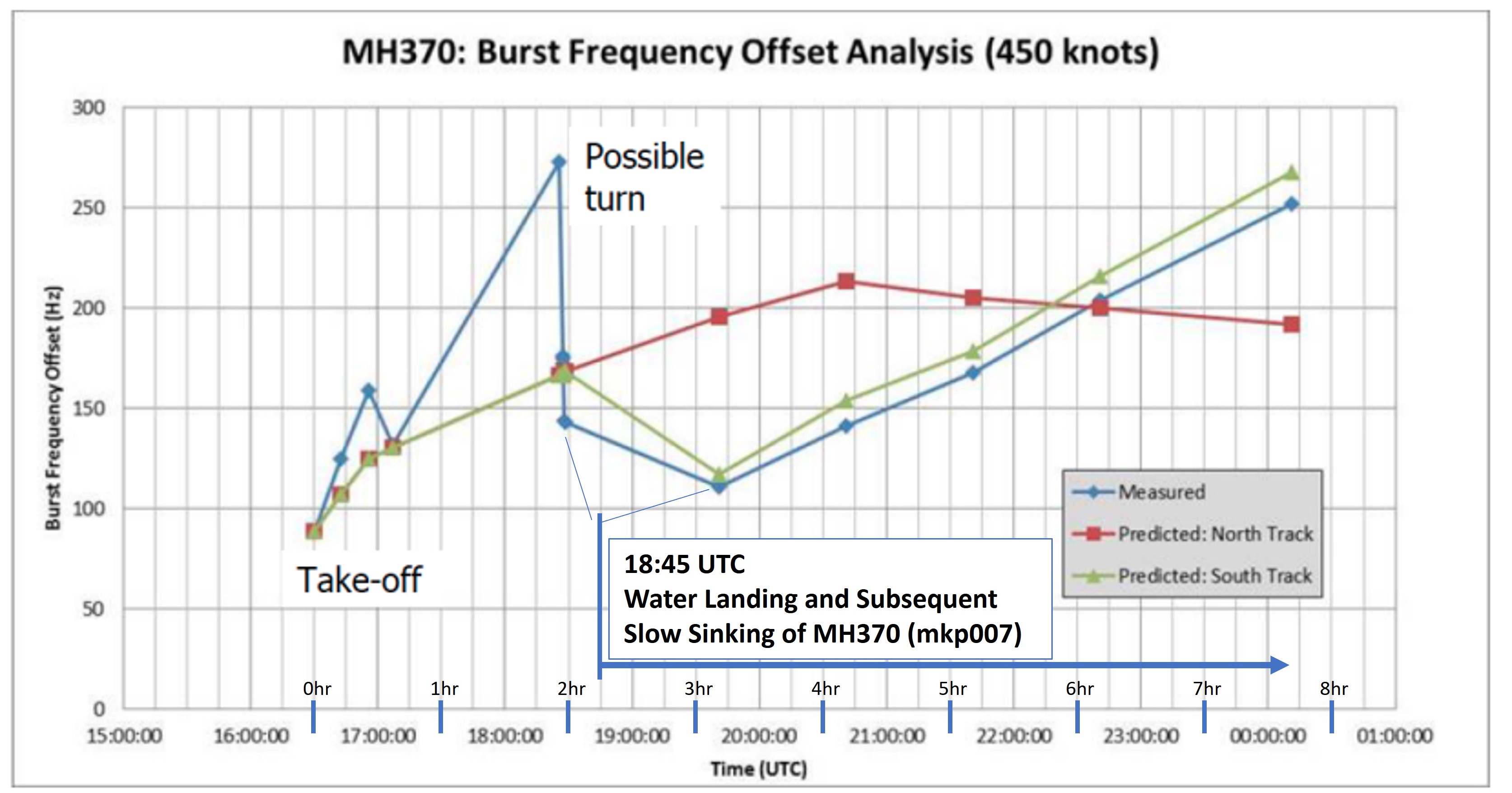
When I see the predicted path of MH370 based on InmarSAT-3F1 data, it is curved and follows nearly equidistant from the satellite itself. Is possible that the plane did a water landing at 18:45 UTC and slowly sank. Can MH370 InmarSAT data fit to an early water landing? After all, the data simply suggests that the distance between the aircraft and the satellite is getting larger. If the plane's antennas are submerged, how does this effect the transmission?
Notes/Assumptions:
- The best estimated path assumes the plane is flying at a cruising speed of 400-450Knts after 18:45 UTC. The varying BFO values indicate the aircraft was moving at speed. I'm suggesting it lands in water and floats for several hours to possibly days.
- The uplink for InmarSAT-3F1 is C-Band which is 4GHz to 8GHz. Needs to be pointed to the satellite and requires the aircraft's navigation system to be operational.
- Victims mobile phones ringing - Many relatives were able to hear a ringing tone for up to four days after the crash.
- The pings from the plane to the satellite stop after about 8hrs which fits well to the amount of potential flight time the plane could stay in the air for. This one is tough to ignore. It fits nicely. But we will assume the plane has enough battery backup to send a signal for an additional 6hrs after the water landing. This of course would be a super big coincidence. But the odds are equivalent to a one outer on the river. Certainly not impossible.
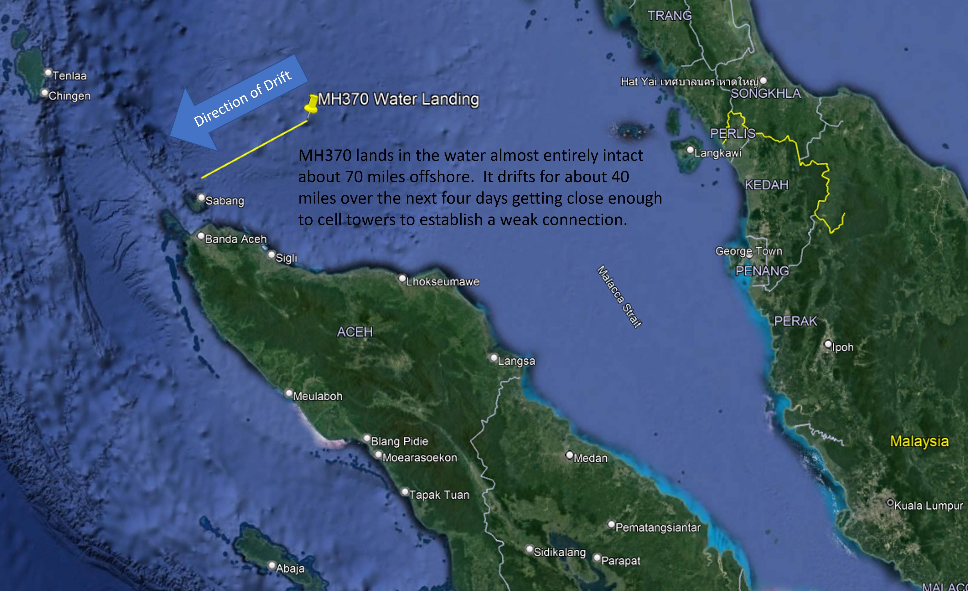
So we are assuming a soft water landing near where the radar return of MH370 "suddenly" stopped. This is at coordinates 6°36'28.75"N and 96°18'38.22"E. This is about 70 miles away from the nearest shoreline. The plane's InmarSAT SDU transponder could still remain locked to the satellite and send out signals. Let's assume that the plane is mostly intact and taking on water slowly. Backup power cuts out after 6hrs. Over the course of several days, the plane drifts towards land with just enough reception to initiate connection. Reference 13 suggests up to 40 miles over open water maybe possible. At somepoing soon after, the plane sinks. It is still almost entirely intact minus a few parts which float off and eventually are found on distant shores.
References:
- https://personal.utdallas.edu/~zweck/MH370_UNM.pdf
- https://arxiv.org/pdf/1702.02432.pdf
- https://www.hydro-international.com/content/article/underwater-electromagnetic-propagation
- https://www.asiasat.com/news/blog/wet-antenna-attenuation-techniques-mitigate-ultra-high-rain-fade-c-band-uplink
- How does one interpret the satellite data on flight MH370?
- Why do MH370 Indian Ocean INMARSAT distances increase when they should decrease?
- https://www.thesun.co.uk/news/8741602/mh730-mystery-satellite-turned-on-vanished/
- interactive.satellitetoday.com/inmarsat-exec-talks-about-operators-role-in-search-for-mh370/
- mh370.org/mh370-fuel-endurance/
- mh370.org/mh370-penang-diversion/
- mh370.radiantphysics.com/2018/04/11/the-civilian-radar-data-for-mh370/
- en.wikipedia.org/wiki/Malaysia_Airlines_Flight_370_satellite_communications
- mobiletechaddicts.com/cell-phone-signal-underwater/


