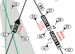
I don't have access to Jepp charts, but I do have access to SkyVector and this March 2012 Jepp legend.
1. On a Jeppesen IFR low enroute chart, there's occasionally a different altitude below/next to the MEA with a "T" next to it. (For example: V16 between GACEB and SHAKY, there's a "2900T" next to the 4500 MEA.) What is this "T" altitude?
From page ENROUTE-6 on the Jepp legend:

35— Minimum Obstruction Clearance Altitude (MOCA).
This corresponds with the Government chart which has, on V16 between GACEB and SHAKY, the MEA 4500 above the MOCA *2900.

2. Similar to the question above, but on a Jeppesen high enroute chart, there's occasionally a "D" below/next to a given altitude. (For example: Q20 between FUSCO and JCT, there's 18000, with "24000D" below it.) What is this "D" altitude?
The 2012 Jepp legend does not list what a "D" suffix means on an altitude, but it does say (referring to the above screengrab)
34— GPS MEA.
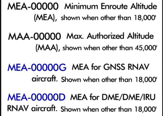
We can compare to the Government legend:

and we can say with confidence that the "D" suffix lists the MEA for a DME/DME/IRU-equipped aircraft, just as "G" indicates the MEA for a GPS-equipped aircraft.
3. On a Jeppesen STAR, there are a combination of dashed and solid course lines. (For example: On KDFW's Sasie 6 Arrival, there are several dashed course lines prior to Sasie, after which the course is marked by a solid line.) What is the difference between the dashed and solid lines?
From page SID/STAR-4 of the Jepp legend, a thick solid line represents a "common course used by multiple transitions" while a thick dashed line represents a "transition track." This is analogous to the thick black line for common routes and thin black line for transition routes on Government charts.


