6
$\begingroup$

I am training to get my instrument rating and I have come across a confusing point. I understand that, when flying a precision approach, you go missed upon reaching the decision height for that approach if visual reference to the runway environment is insufficient to complete the landing. I also understand that on a non precision approach you will descend to the minimum decision altitude for that approach and then fly at that altitude until you reach the missed approach point, after which you will go missed. My question is, how do you know when you've reached the missed approach point on a non-precision approach?

These three charts in particular confuse me:


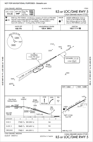
In this approach, which has an option for either an ILS (precision) or LOC/DME (non-precision) approach, the beginning of the dotted line which signifies the missed approach path does not have any DME value or intersection information. There is an intersection after it at 7.5 DME. Which of these two points would be the missed approach point for the LOC/DME approach? How would you know when you reached the MAP if it is where the dotted line begins?

enter image description here
(Click to view)


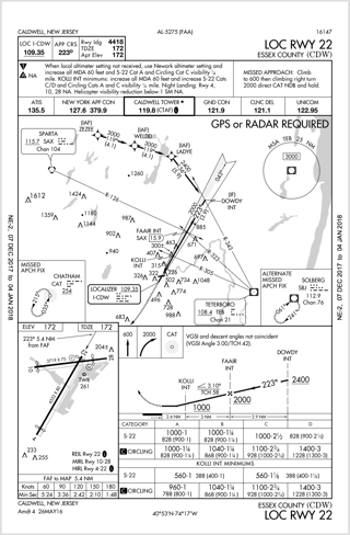
In this approach the dotted line which signifies the missed approach path seems to begin at the runway threshold. If this were the MAP, (with no localizer) would you have to start a timer after you cross KOLLI intersection to know you have gone 2.4nm and thus are over the runway threshold? Is the MAP actually at the beginning of the runway as it seems? Are there any ways of knowing you are at the MAP without a stopwatch?

enter image description here
(Click to view)


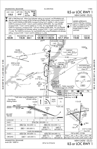
Finally, this IAP is similar to the first. Unlike the first though, there is no DME intersection after or near the beginning of the dotted missed approach line. Is the MAP for the localizer approach here just at the beginning of the runway as it seems to be in the second approach? Again, would you have to use a stopwatch or are there any other ways?

enter image description here
(Click to view)

$\endgroup$

2 Answers 2

9
$\begingroup$

Non precision MAP fixes are identified in a number of ways:

  • Fixes identified by additional terrestrial Navaids eg intersections between the localizer and radial directions from other Navaid beacons like VORs, NDBs, etc..
  • Fixes identified by DME slant ranges.
  • Fixes identified by flying a linear course from an identified FAF at a specific airspeed for a specific time.
  • Fixes identified by area navigation systems.
  • Fixes identified by specific GNSS waypoints (RNAV GPS).

For the ILS or LOC/DME rwy 5 KCGZ, when flying the LOC/DME, Your MAP is on localizer at MDA at 7.5 NM DME from the Stanfield (TFD) VORTAC. There is no other means using the equipment required to fly this approach procedure to identify the MAP.

For the LOC rwy 22 into KCDW, your MAP is on localizer at or above MDA when you cross the threshold of rwy 22. Flying the approach at the correct category airspeed, you can also time it using the table in the lower left corner of the plate. But the plate clearly says that the MAP is 5.4 NM from the FAF.

For the ILS or LOC 1 into KILG, the LOC rwy 1 MAP is again on localizer at MDA when the aircraft crosses the threshold of rwy 1. This is defined by the approach timetable on the lower right of the plate.

$\endgroup$
5
  • $\begingroup$ Ah, I didn't see those timetables. That makes sense. However, are you sure the MAP is that last waypoint (TFD 7.5) for the first approach? How do you know it is not the runway threshold as it is in the approach brought up in this question: aviation.stackexchange.com/questions/21437/… $\endgroup$ Commented Jan 4, 2018 at 6:28
  • $\begingroup$ Yes. There is no other means available to identify the MAP otherwise. $\endgroup$ Commented Jan 4, 2018 at 6:49
  • $\begingroup$ So whenever there's an intersection after the precision MAP on a precision/np approach plate the MAP is not over the runway threshold but is at that intersection? What if the FAA wanted the MAP for the np approach to be before the MAP for the precision approach? If it is just marked with an intersection, how would you know that an intersection before the precision MAP was not the np MAP? Why isn't this made clearer? It is especially ambiguous on ILS or LOC/DME approaches because you don't have a time table to verify the np MAP. Isn't this dangerous? $\endgroup$ Commented Jan 4, 2018 at 7:19
  • $\begingroup$ The position of the MAP on a non-precision approach is specific to the approach being flown; there is no hard and fast rule like that to follow. Again the best way to determine where the MAP is by thoroughly briefing the approach plate during flight planning and again before entering the terminal environment. It’s not dangerous as long as you understand what is going on here. $\endgroup$ Commented Jan 4, 2018 at 16:02
  • $\begingroup$ Ok. I still wish they made it a bit clearer whether in the first approach whether the LOC/DME MAP was 7.5 or 7.8 dme but I guess you just have to use common sense - that they wouldn't include an intersection that didn't define a lower altitude or the FAF for the np approach that WASN'T the MAP. Also I don't think they would ever put the np MAP before the glideslope MAP on np/p plates because obstacle clearance in that area would already be assured for the glideslope app and they might as well give the np approach a better chance to see the runway by sending them closer (since they are higher). $\endgroup$ Commented Jan 4, 2018 at 21:16
2
$\begingroup$

I realize this post is 5 years old but hopefully I can clarify for someone down the road. I’m 30+ years instrument rated, former CFI, 20+ years ATP mil and civil and I myself looked this up today…life happens.

In the mil they always foot-stomped reading the title of the approach to determine minimum equipment required to legally fly it. The title always indicates required equipment to fly from FAF to MAP; nothing more. So it’s up to us to determine if and how we can fly full segment (prior to FAF) and the published MAP. If not properly equipped, you must request alternate means. This is typically RADAR vectors to intercept FAF and then heading/altitude for vectors as alternate MAP.

To the OP question, LOC/DME Rwy 5; LOC/DME in title and absence of timing table was the clue.

Also, compare timing table FAF to MAP distance to profile view of approach procedure.

Tip—include runway exit gameplan to approach brief because this is a horrible time to reference plate.

Another tip—after years of vector to ILS full stop, your full segment and MAP skills will go to crap. Focus on this.

Every airport is surveyed for surroundings and approaches are tailored for available equipment, terrain, traffic count, etc and this is why approaches, especially non-precision approaches, are so you unique.

Fly safe!

$\endgroup$
2
  • $\begingroup$ To clarify your answer a bit, the title of the procedure refers to the lateral guidance on final. The FAA has moved away from including “DME” in the title, instead opting to place that in the equipment requirement box located in the pilot briefing bar. You should expect to see “ILS or LOC RWY XX” as the title and “DME required.” in the pilot briefing bar when it is required anywhere from the IAF through the published missed approach procedure. $\endgroup$
    – Timbo
    Commented May 23, 2023 at 22:35
  • $\begingroup$ Timbo, you are correct. Thanks for adding that. $\endgroup$
    – Postal123
    Commented May 24, 2023 at 13:56

You must log in to answer this question.

Not the answer you're looking for? Browse other questions tagged .