7
$\begingroup$

Sorry if the question title here is a bit misleading, the graphic here should explain all:

enter image description here

I read a news story this morning about how a guy flying a Robin DR400 regularly creates inventive patterns in his flight tracks.

Source

The question is, how would the pilot be able to create this writing (and other creative patterns)? Autopilot instructions? Watching himself on FlightRadar?


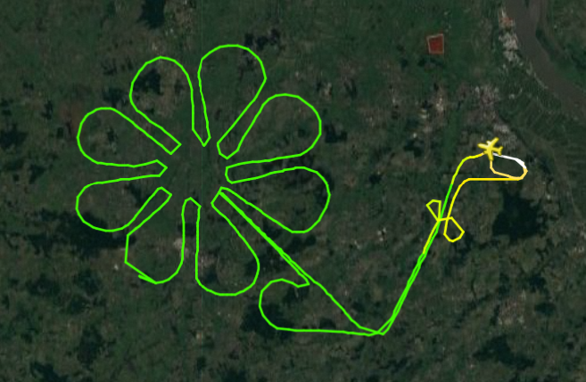
enter image description here

$\endgroup$
4
  • 5
    $\begingroup$ What about creating a path on a GPS device before, and following it with the aircraft? Seems to be the simplest and easiest solution. $\endgroup$
    – sweber
    Commented Dec 2, 2016 at 10:22
  • 4
    $\begingroup$ The title looks fine to me -- I knew what you meant as soon as I read it. $\endgroup$ Commented Dec 2, 2016 at 10:33
  • $\begingroup$ Far better drawings here by the same aircraft. $\endgroup$
    – Notts90
    Commented Dec 2, 2016 at 12:10
  • 2
    $\begingroup$ Here is how I'd attempt: an iPad, a GPS app, and a plastic sheet with the pattern. $\endgroup$
    – kevin
    Commented Dec 2, 2016 at 12:41

3 Answers 3

6
$\begingroup$

Most Robin 400s don't have autopilots, but some do. Whether it has an autopilot or not it was almost certainly navigated using a pre-set course which was fed into a GPS. One would use flight planning software to create a course using a series of waypoints which would then be uploaded to a built-in or handheld GPS, and then either flown by hand or followed by an autopilot.

You can see that the curves are mostly a series of small straight lines, I think that these straight lines are the space between waypoints, it could be the refresh between the FlightRadar inputs causing the lines though.

$\endgroup$
6
  • 1
    $\begingroup$ Interesting. I've seen straight lines on FlightRadar tracks and assumed that they were just straight lines drawn between sampling points. Then again, I don't know how often those positions are collected by FR. $\endgroup$
    – user12007
    Commented Dec 2, 2016 at 12:03
  • $\begingroup$ I think Pete is right; these straight lines are definitely caused by FR's sampling rate. $\endgroup$
    – Sanchises
    Commented Dec 2, 2016 at 12:36
  • $\begingroup$ Additionally, you need something that FlightRadar can track. A transponder or ADS-B Out. It can sometimes use radar returns as well, but you'd have to be within radar range of some station. $\endgroup$
    – Ron Beyer
    Commented Dec 2, 2016 at 13:10
  • 1
    $\begingroup$ Seriously? Look at the map scale. The features in the upper part of the 'H' are drawn with a radius of about 200m. The Robin can hardly make tighter turns. If the corners in the track were from anything else than the time resolution, this would mean turn radii of merely meters. $\endgroup$
    – bogl
    Commented Dec 2, 2016 at 15:02
  • $\begingroup$ In theory, couldn't they also be made by having a line on your GPS showing where you had already flown, allowing you to just kind of eyeball it? I do think you'd need GPS, but I'm not sure you need to have a pre-set plan. $\endgroup$
    – Jae Carr
    Commented Dec 2, 2016 at 15:52
4
$\begingroup$

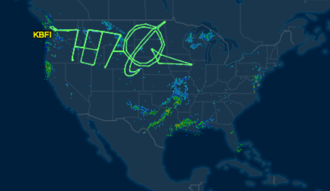
During test flights to put time on the aircraft, the 787 flew some pretty cool designs like this as well, using much of the U.S. as their drawing canvas.

787 & Boeing logo drawn with flight path
(You can see this design and the filed route on FlightAware )

Since they were at high altitude & on an IFR flight plan they did have to file their points with ATC. (A total of 81 waypoints were used for the "drawing" portion of the flight, mostly latitude/longitude coordinates. Bet they didn't file that over the phone!)

I think there was another that overflew every state in the lower 48, but I can't find it right now. (Anybody, feel free to edit in the link if you find it.)

In the 787 case, the autopilot certainly was used... for the R222, maybe not so much!

$\endgroup$
0
$\begingroup$

Although I agree with the above answers I thought that the pilot may have flown the flight as he preflighted it. How did you fly cross-country flights? Pick your points and fly them. You would need a chart and the rest of your preflight planning kit; pilotage, 'I follow roads' and any of the other navigational aids mentioned in the other answers.

$\endgroup$

You must log in to answer this question.