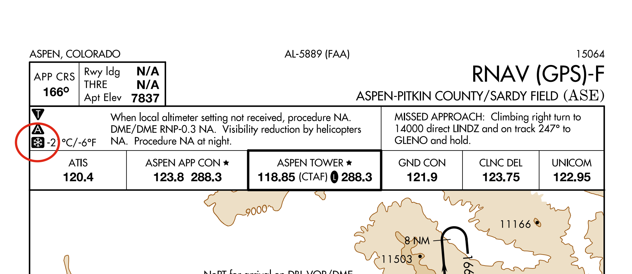
I've only seen the snowflake symbol with temperature listed on this one approach plate for KASE airport in Aspen, CO. I looked for it in the legend but didn't find it. Does anyone know what the snowflake symbol with temperature means?

From FAA INFO 15002:
A [snowflake] -XX°C icon will be incrementally added to airport approach plates, beginning Mar 5, 2015. The icon indicates a cold temperature altitude correction will be required on an approach when the reported temperature is, “at or below” the temperature specified for that airport.
This looks to be a work-in-progress, as they started adding the icons in March, and compliance with applying the cold temperature altitude corrections becomes mandatory in September, 2015.
More info from the NBAA:
Background: In response to aviation industry concerns over cold weather altimetry errors, the FAA conducted a risk analysis to determine if current 14 CFR Part 97 instrument approach procedures, in the United States National Airspace System, place aircraft at risk during cold temperature operations. This study applied the coldest recorded temperature at the given airports in the last five years and specifically determined if there was a probability that during these non-standard day operations, anticipated altitude errors in a barometric altimetry system could exceed the Required Obstacle Clearance (ROC) used on procedure segment altitudes. If a probability, of the ROC being exceeded, went above one percent on a segment of the approach, a temperature restriction was applied to that segment. In addition to the low probability that these procedures will be required, the probability of the ROC being exceeded precisely at an obstacle position is extremely low, providing an even greater safety margin.
Action: Pilots must make an altitude correction to the published, “at”, “at or above” and “at or below” altitudes on designated segment(s) (see list below), on all published procedures and runways, when the reported airport temperature is at or below the published airport cold temperature restriction.
Pilots without temperature compensating aircraft are responsible to calculate and make a manual cold temperature altitude correction to the designated segment(s) of the approach using the AIM 7-2-3, ICAO Cold Temperature Error Table.
Pilots with temperature compensating aircraft must ensure the system is on and operating for each segment requiring an altitude correction. Pilots must ensure they are flying at corrected altitude. If the system is not operating, the pilot is responsible to calculate and apply a manual cold weather altitude correction using the AIM 7-2-3 ICAO Cold Temperature Error Table. PILOTS SHOULD NOT MAKE AN ALTIMETER CHANGE to accomplish an altitude correction.
Pilots must use the corrected MDA or DA/DH as the minimum for an approach. Pilots must meet the requirements in 14 CFR Part 91.175 in order to operate below the corrected MDA or DA/DH. Pilots must see and avoid obstacles when descending below the MDA.
The temperature restriction at a “Cold Temperature Restricted Airport” is mutually exclusive from the charted temperature restriction published for “uncompensated baro-VNAV systems” on 14 CFR Part 97 RNAV (GPS) and RNAV (RNP) approach plates. The charted temperature restriction for uncompensated baro-VNAV systems is applicable to the final segment LNAV/VNAV minima. The charted temperature restriction must be followed regardless of the cold temperature restricted airport temperature.
There's more info in the NBAA document (I only included the exciting parts), including a list of affected airports, listed by state. Lots in Alaska, none in Florida, unsurprisingly. Applying this in flight looks like an absolute can of worms, as far as I can tell from the examples presented.
We'll probably see more come out about this as cold weather approaches, so stay tuned!
It indicates a "temperature restricted" airport where precautions are required to calculate and set correct altimeter settings because the errors caused when the temperature is at the lowest recorded , if not corrected, can exceed the required obstacle clearance shown on the chart.
Since the air is significantly more dense than the "ISA standard day", the altimeter can over read (the pressure for a given altitude will be greater), telling you that you are higher than you really are with a risk of ground or obstacle collision.
If the temperature is at or below that shown on the chart, altitude corrections must be made.