10
$\begingroup$

Would a very small airfield or airstrip be considered to be a 'terminal' and have Automatic Terminal Information Service (ATIS)? Or would it just have minor weather reporting?

As in, would it make sense to provide ATIS (Automatic 'Terminal' Information Service) for a very minor airstrip? How does an airstrip qualify as being a 'terminal' to require those services?

$\endgroup$
0

4 Answers 4

9
$\begingroup$

There is no minimum definition of a "terminal" in and of itself. The "destination terminal" of a flight is simply its planned endpoint. That's usually, but not always, a man-made complex designed to facilitate human flight, which we call an airport. However, you can file a VFR flight plan to fly out to a friend's fallow field in BFE, miles from any airfield listed on a sectional:
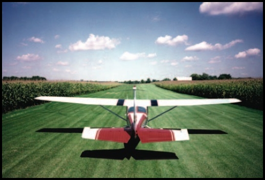
enter image description here

It's then your responsibility, as it always is in VFR, to ensure you can operate the plane safely at all times, including getting the plane on the ground and then back up in the air without causing personal injury, property damage, infringing private property rights, violating noise ordinances, etc.

Sectional diagrams use the term "airport" to refer to any place that is registered with the FAA to be used for the purpose of aircraft takeoffs and landings. These places may be more specifically called airstrips, airfields, air parks, aerodromes etc to indicate relative size, construction, ownership or facilities.

The only requirements for an airport to be documented by the FAA and appear on a sectional are:

  • The location must meet minimum guidelines specified in the Airport Certification Manual, including land grading for smoothness and drainage, obstruction/obstacle clearance in three dimensions, and minimum safety markings and wind/traffic pattern indicators that are necessary to support aircraft takeoffs/landings at the location (really the only thing every airport requires along these lines is a windsock; everything else is provided as needed for the specific location or as desired by the field's users). This usually requires a minimum amount of maintenance/upkeep by its owner for the purpose, even if it's just a grass field (it would have to be regularly mown and weeded to remove certain spiky or wood-stemmed plants, for instance).
  • The location must be registered with the FAA by its owner/manager for this purpose (they can register it as a reserved/private airfield, and then only limited information will be given on the sectional, primarily as an advisory that the location is available for emergency landings).

That's all there is to it. Besides a windsock which is the absolute minimum, no minimum facilities must exist; even the traffic pattern/landing direction indicators are optional if traffic can always use a left-hand pattern and determine the runway approach from the windsock. Rhome Meadows Airport (T76) between Fort Worth and Decatur, TX is a grass strip, with no lights, no tower, no fuel, no hangars, and the displaced threshold on the south end is marked with two white painted tires (no threshold markings to the north). Nearby Heritage Creek Airstrip is only slightly better, with low-intensity runway edge lights. Despite this, both are fairly active for unimproved strips, with about nine flights a day involving each one in some way (TO/L, T&G).

Here's the airport section of the legend for FAA sectionals:
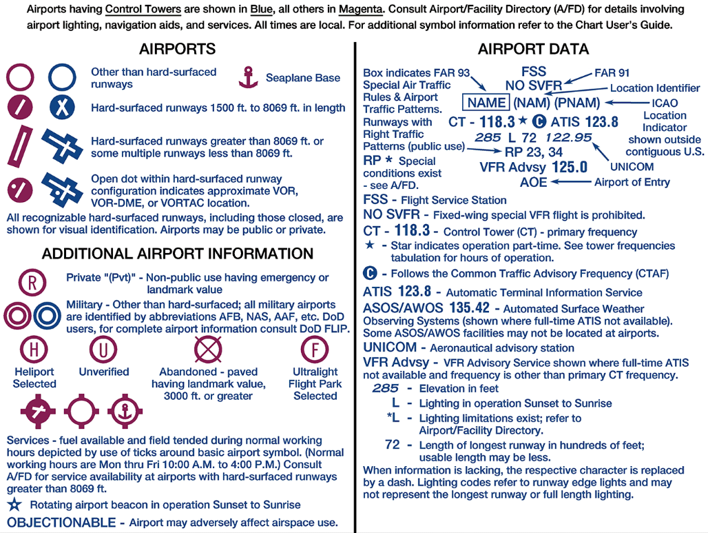
enter image description here

You can see that there's a wide array of symbology available to indicate at a glance what the facility offers; control tower or no, length and configuration of hard surface runways if any, usage type, presence of FBOs for fuel/maintenance, navigational aids, and radio information including ATIS, AWOS, ASOS, control towers, UNICOM etc. Obviously a control tower needs a radio frequency, but there is no requirement that a towered facility have ATIS. ATIS is usually found at towered airports as its purpose is to reduce controller workload, but nontowered airports can have ASOS/AWOS stations which provide practically the same information regarding weather, without the superfluous runway information (at nontowered airports, the pilots usually determine the approach/departure direction). If an airport has no reporting whatsoever, you would usually tune to the nearest listed AWOS/ASOS.

$\endgroup$
5
$\begingroup$

No, small airports almost never have ATIS. Many do, however, have an AWOS or ASOS. However, this is also not a requirement and many very small and/or private fields don't have any weather reporting at all. If any such system is present, its radio broadcast frequency will be listed on the sectional charts. When no weather reporting service is available at a particular airfield (either due to there not being one there or it being out-of-service,) pilots will generally just tune in to the weather reporting frequency of another nearby airport that is likely to have sufficiently similar weather.

The word 'terminal' is used in aviation to describe any type of airfield, regardless of its size. However, the presence of the word 'terminal' in the name for ATIS is not meant to imply that all terminals have ATIS, but only that all ATIS's are associated with a terminal.

AWOS (Automated Weather Observing System) and ASOS (Automated Surface Observing System) systems, as their names imply, automatically monitor local weather conditions. They then produce a computer-generated voice that plays this information in a loop on a radio frequency that will be stated in the A/FD entry for the airport and listed on the sectional charts.

ATIS includes weather information like an AWOS or ASOS, but also includes information about the airport itself, such as which runway(s) are active, which approaches are available, and anything else the local air traffic controllers want pilots to know before they contact ATC. This is not needed at small airports because they don't have air traffic controllers and pilots just choose which runway they're going to use based on current traffic and weather conditions and tell each other about it on the radio. It's also not present at some smaller airports that do have towers because the controller workload is low enough already that it isn't needed. At larger airports, though, having ATIS available helps to prevent controllers from having to waste time repeating the same information to every single pilot approaching the airport and also helps to free up the radio frequencies used by the controllers, allowing pilots and controllers to relay information to each other more quickly and efficiently.

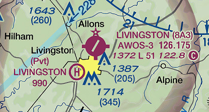
For example, Livingston Municipal Airport is a small airport near where I live that has an AWOS-3 transmitting on 126.175 MHz:
Livingston Sectional Chart

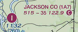
The smaller nearby Jackson County Airport, however, has no weather observation facilities. Aircraft approaching this airport would probably just listen to the weather report from Livingston or another nearby airport:
Jackson Co Sectional Chart

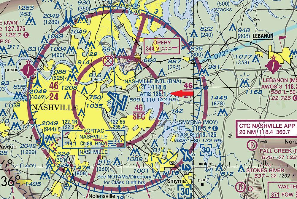
The much larger nearby Nashville International Airport does have ATIS service operating on 135.1 MHz:
BNA Sectional Chart

$\endgroup$
0
3
$\begingroup$

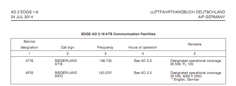
In Germany, most airfields that are equipped or certified for IFR operations will have an ATIS. In those cases were an airfield is not equipped with an ATIS, all weather information produced by the certified meteorological personnel at the airfield will be provided on the AFIS (Aerodrome Flight Information Frequency) frequency upon request.

EDGS AD AIP
(Image Source: AIP Germany AD EDGS)

For all airfields that neither have certified meteorological personnel or equipment, the weather information will be rudimentary, such as winds only, but no QNH, precipitation or cloud observation. ASOS or AWOS are not used in Germany.

$\endgroup$
3
$\begingroup$

Airstrips provide at least a wind sock (or wind cone) to indicate direction and strength of the wind at ground level.

A wind sock is required to operate even the tiniest strip, and as such provides the minimum level of weather information available - provided the pilot is close enough to be able to see it clearly.

The specifications of this information source are discussed in the answers to this question.

Note the FAA specification available here.

$\endgroup$

You must log in to answer this question.

Not the answer you're looking for? Browse other questions tagged .