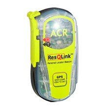
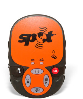
Relatively short answer
Cospas-Sarsat: Feasible but...
It's possible, but there are many individual elements involved. It's a matter of probability that most of the time there will be a combination preventing the link to work. If you know what to do and take care of ensuring a good direct line of sight (LOS) you may be able to avoid some of these combinations. It cannot work underwater.
Parameters that can attenuate the signal reaching the satellite receiver are of different origins:
- The aircraft design itself (composite materials or aluminum, number of windows, ...)
- The location of the accident (canyon, trees, ...)
- The transmitter use (position, window proximity, metallic surface or debris interference, body proximity, ...)
I'm not aware of experiment results for using a PLB within a metallic container like a commercial aircraft cabin. It's still possible to evaluate the RF channel loss in different configuration and see if the signal can reach the receiver with the minimum required level.
As explained in the next sections about the Sarsat satellites of the international SAR service on 406 MHz:
- The threshold for signal reception by the receiver is 161 dBW.
- With an initial power of 7 dBW (5 W), the attenuation must be at most 168 dB
- In good conditions we can expect an attenuation of "only" 148.1 dB. Such signal 12.9 dB stronger that the threshold can be detected easily.
- In degraded conditions we may experiment an attenuation of 177.5 dB. Being 9.5 dB below the threshold, this signal is not detected.
Indoor transmission put the system at its limits of detection capability (a S-meter unit is 6 dB).

Weak signal on a S-meter, S-unit is 6 dB (source)
Many small attenuation causes that, when summed, can prevent the link to work must be taken into account, hence this answer is a long one.
SPOT LLC
SPOT LLC solution you mention is a commercial messaging initiative working on 1.6 GHz, out of the Cospas-Sarsat system. Higher frequency means higher attenuation. The limited 0.4 W RF output also makes the signal weaker. It's very unlikely that SPOT could work within the cabin.
Details
Introduction: PLB principles
Emergency PLB operate on 406 MHz. The previous 121.5 MHz civil frequency is not monitored anymore by SAR satellites, but can be used (in addition of the actual signal at 406 MHz) as a homing guide for the SAR team. They are informed about whether this homing feature is active or not by the message sent by the PLB.
PLB output power is 5 W (equivalences: 7 dBW 37 dBm) at 406 MHz, in vertical polarization.
From C/S T.004, the performance of the satellite system is:
- A "probability better than 95% to provide a valid solution (15 hexa identification provided) for a beacon transmitting with a 37 dBm output power (with a whip antenna) and for satellites passes with elevation above 5°)"
- A "probability better than 95% to provide a Doppler location with an accuracy better than 5 km"
There are no satellites entirely dedicated to the SAR service, rather distress signal receivers are carried as one of the payloads aboard satellites. The system is made of two constellations:
GEOSAR constellation, Geostationary Earth Orbit SAR. These satellites are at fixed positions, 36,000 km above the equator, and are covering the globe except the polar regions.
LEOSAR, Low Earth Orbit SAR. Satellites in near-polar (about 85°). LEOSAR is made of two sub-constellations: Sarsat satellites orbiting at 850 km, and Cospas satellites orbiting at 1,000 km.

(Source)
A third constellation is planned to operate at a higher altitude than LEOSAR (MEOSAR, currently not fully deployed).
While GEOSAR are likely to be first to detect the PLB activation due to their permanent LOS, LEOSAR will provide the best detection due to the shorter distance to the device.
I'll focus on LEOSAR / Sarsat payload which provides the best chances for the detection of a PLB signal partially blocked by RF impermeable obstacles.
Sarsat payloads
Satellites carrying a LEOSAR Sarsat payload are NOAA 15 (Sarsat 7), NOAA 18 (Sarsat 10), NOAA 19 (Sarsat 12). Other are scheduled to be active in the future (some may be already, I haven't checked). They are fitted with a SAR receiver (search and rescue processor, SARP). Sarsat satellites can be tracked on N2YO.com.
According to Cospas-Sarsat LEOSAR Space Segment Commissioning Standard - C/S T.004, a SARP-2 has a sensitivity of -161 dBW, and SARP-3 -164 dBW (that's about 60 attowatts to be compared with a cellular phone cell: -134 dBW, 1,000 times less sensitive).
Can this small quantity be delivered to the SARP from the inside of a cabin?.. This is a matter of knowing the initial power, and determining the loss along the wave path until the signal reaches the receiver.
The power generated by the transmitter amplifier is 5 W, or 7 dBW. 161 dBW on the receiver means receiving a 1 W signal that has been attenuated by 161 dB. If we have already 7 dBW at the source, we can bear a maximum attenuation of 168 dB.
Main loss inventory
Propagation loss in direct view
The most important part of the signal will be lost in the atmosphere between the antenna of the PLB and the antenna of the SARP.
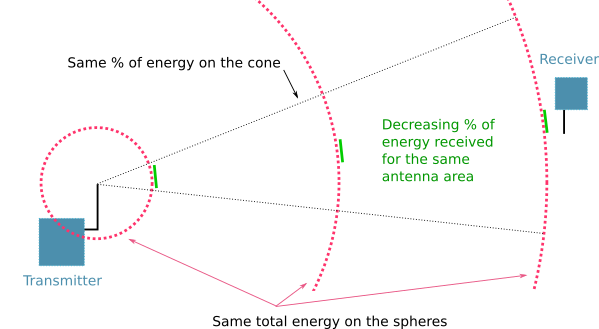
Loss due to distance
Loss is dependent on two factors: distance and wavelength. Both factors limit the area of the receiving antenna compared to the whole sphere of the wave front, and in consequence the portion of energy received is smaller too.
- Using the propagation model ITU-R P.525 (free-space propagation).
- Distance = 850 km, f = 406 MHz.
- Assuming isotropic antennas for the time being.
- According to the model, the loss (dB) is:
Lbf = 20 log(4πd/λ)
. = 32.4 + 20 log(f) + 20 log(d)
. = 32.4 + 20 log(406) + 20 log(850)
. = 143 dB
The signal that left the PLB antenna reaches the SARP antenna -143 dB weaker, assuming the best antenna alignment. But this is never the case, because when in a polar orbit, the satellite is unlikely to be exactly above the beacon.
Misalignment of the receiving antenna
There will be an angle between the nadir of the SARP and the beacon. This off-nadir angle, depends on the actual track of the satellite for the current orbit:
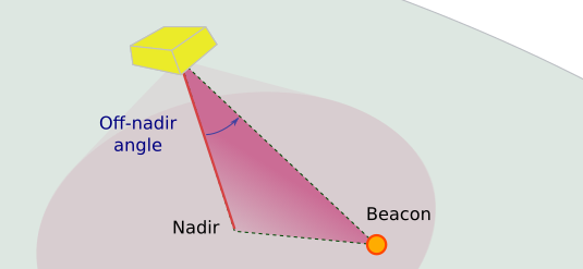
Target off-nadir
The gain of the antenna varies according to this angle. Sarsat-TIROS SARP Receive Antenna (UDA) Gain Pattern:
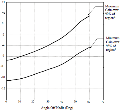
UDA antenna gain at different off-nadir angles (source)
Assuming the polarization is favorable (RHCP), the gain may varies between +2 dB and -10 dB. Note that:
The gain is better when the off-nadir angle is large. This is likely to compensate the higher distance to the beacon.
I'll assume a link length f 850 km, but the actual length is larger when the beacon is not directly at the satellite's nadir.
We should now work with the probability distribution of the misalignment for the LEOSAR antennas to have the full range of possibilities and their likelihood (e.g. Monte-Carlo simulation). To simplify, let's just use a bad case: -4.4 dB (this is not the worst possible). Loss so far: -147.4 dB (-143 - 4.4).
Attenuation due to feeder and duplexer
On the satellite, the SARP is connected to an antenna via a duplexer to isolate the SARP uplink antenna from the SARR downlink signal (SAR repeater used on local mode, not detailed here):

Hardware on the Sarsat satellite (source)
The duplexer + feeder loss is -1.6 dB. Loss so far: -149 dB (-147.4 - 1.6).
Loss margin left
We had a budget for -168 dB loss, we have used -149 dB. The margin until the PLB signal is lost by the SARP is 19 dB, assuming we are in this configuration:
- PLB is outdoor.
- The LOS is completely clear, no foliage, no roof, etc.
- PLB antenna has no gain/loss (0 dB gain).
- PLB antenna is vertical, this is the normal use of the SAR device.
- PLB antenna and RF output stage impedances match (no SWR).
- There is no atmospheric loss (free space)
Additional losses
It's time to re-look at the assumption made until here, and take into account the additional effects encountered when the PLB is used from the cabin of a crashed aircraft.
PLB is outdoor.
- Actually the PLB is behind a cabin window.
From Arkema:
"Most formulations of colorless Plexiglas sheet readily transmit standard broadcast, television and most radar waves of the electromagnetic spectrum". It can been assumed that windows (including the internal protection sheet) don't block the PLB signal. Loss = 0 dB.
In the cabin, numerous reflections will occur on the wall, and due to the closed space with only small windows, it's likely the reflected signals will globally interfere in a destructive way (phase mismatch) with the original signal.
If the PLB is displaced, even by a small amount, the reflections are changed. The RF energy actually vary continuously, creating a fading effect. Reflections has been studied in somehow comparable environments, for UHF frequencies. While the frequency was a bit higher, and the environment was a simple one, we can use the results for a rough order of magnitude:
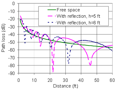
RFID signal (915 MHz) loss due to reflections (source)
The spatial fading is visible, at some distances reflected signals add, at other they subtract. This loss is also known as multipath effect. The signal may be attenuated by 10 dB or more compared to free space.
Each reflection has also the potential to change the polarization. See next point.
PLB antenna is vertical, this is the normal use of the SAR device.
The transmitter and receiver antenna polarization must match or an attenuation occurs. The polarization of an antenna describes the plane in which the electric field is transmitted. For a simple antenna, made of a single active element, the electric field is sent in the plane of the element:

Vertically and horizontally polarized waves (source)
Vertical polarization creates less reflection on the ground, which is usually what is desired, so a PLB creates a vertical polarization, but only if the antenna is kept vertical, else the polarization will follow the antenna orientation.
To cop with both linear vertical and horizontal polarizations, and everything in between, the SARP antenna is designed to be circularly polarized, and is able to receive both in good conditions, but not optimal conditions:
linearly polarized antennas will work with circularly polarized
antennas and vice versa. However, there will be up to a 3 dB loss in
signal strength. In weak signal situations, this loss of signal may
impair communications (source).
- The antenna on the satellite should be like this:
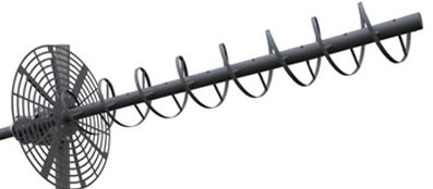
Helical, circularly polarized, antenna (source)
The LOS is completely clear, no foliage, no roof, etc.
Indeed, if there is a metallic obstacle in the LOS and there is no possibility for reflections (no hole in the metallic cabin), no signal is transmitted. This could happen if the PLB were surrounded by metallic debris from the airplane wreckage.
Else there is a volume (the Fresnel zone) between the transmitter and the receiver that must be free of obstacles. This zone is an ellipsoid around the LOS. If obstacles are present there will be diffraction and reflection. Diffraction scatters the signal (no need to have knife-edge corners), and reflection deviates it, which could be a positive effect when there is no clear LOS.
Dense vegetation or heavy foliage on the LOS: There is water in plants, a loss occurs, typically larger than 0.1 dB/m at 406 MHz. We can use models to evaluate the attenuation:
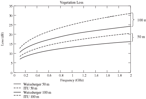
(Source, page 155)
Example: The aircraft crashed in a forest. The aircraft is surrounded by 25 m trees, except in the direction from which it came.
Satellites low on the horizon will not be accessible: GEOSAR satellites over the equator are usually low on the horizon when viewed for medium latitudes, and some orbits of LEOSAR will be hidden by the trees due to the loss exceeding -15 dB as soon as the depth of foliage is 50 m (slant depth). This depth can be quickly encountered, leaving a small free field of view from a window (it would be larger for the windshield though):
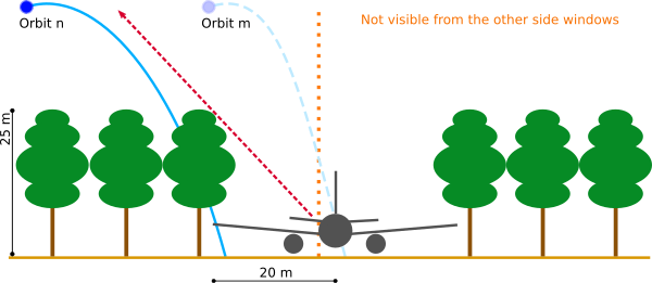
Tree trench created by crash-landing in a forest
PLB antenna has no gain/loss (0 dB gain).
- This is likely the case for many PLB. PLB antenna seems to be a shortened 1/4 λ whip. Antennas are measured against an hypothetical perfect antenna (isotropic antenna), and the ratio of amplification is expressed in dBi (dB comparing to isotropic). dBi and dB are equivalent in the current discussion as the isotropic antenna has a gain of 0 dB.
PLB antenna and RF output stage impedances match (no SWR).
In order for the current out of the PLB RF amplifier to be radiated entirely by the antenna, PLB output impedance and antenna impedance must be equal. As soon as there is a mismatch, a part of the RF current is not converted into an electromagnetic wave and returns to the amplifier, mixing with the current flowing in the other direction. The result is the appearance of standing waves in the PLB device. The ratio of SW is smartly named SW ratio (SWR). PLB are stated having a SWR less than 1.5 or 2 in their specifications. The corresponding loss is 0.2 and 0.5 dB. Not so much.
The impedance of the antenna varies greatly as soon as the antenna is not in a free space. A common cause is that a part of the body (containing water) is close to the antenna, or touching it. This could easily lead to a loss of 10 dB. The radiative efficiency of the antenna (gain) also suffers: Touching the antenna is like deforming it. Its characteristics are changed. For example is is no more optimized for the signal frequency to radiate. So in addition of SW appearance, the current that reaches the radiator is also poorly converted into waves. In your scenario it is important to use the PLB as intended, the antenna being unobstructed.
There is no atmospheric loss (free space).
This is another effect difficult to estimate, as it varies with time of the day, weather aspects and Sun activity.
Oxygen and water vapor play an important role. From ITU-R P.676-10:
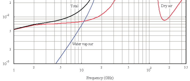 Attenuation in dB per km (source)
It seems for UHF the absorption is rather limited, so let's ignore it.
Other losses are due to sporadic electrical activities in the ionosphere. They are more difficult to estimate, and they translate into noise rather than attenuating the signal received by the SARP. Other elements like the capability of the SARP to reject noise would also need to be considered.
Ionosphere anomalies could potentially introduce errors in the Doppler localization.
Bottom line
Let's recapitulate the losses we have discussed:
 - Impedance mismatch / SWR:                 -0.5 dB
 - Transmitter antenna gain:                 +0 dB
 - Reflection in the cabin:                  -0 to -10 dB (center).
 - Cabin window:                             -0 dB
 - Fresnel obstruction and trees:            -0 to -15 dB
 - Free space loss:                          -143 dB
 - Absorption by atmosphere gases            -0 dB
 - Other propagation losses:                 Not evaluated.
 - Off-nadir angle:                          -0 to -4.4 dB
 - Linear to circular polarization mismatch: -3 dB
 - Satellite duplexer:                       -1.6 dB

                               Acceptable:   -168   dB
                               Best case:    -148.1 dB
                               Worst case:   -177.5 dB
The worst case is encountered when:
The PLB experiments the higher level of reflected waves. This can be eliminated by being very close to the window, and shielding the rest of the cabin with something metallic, but not too close.
The Fresnel ellipsoid is blocked by trees. Not much freedom here. LEOSAT will hopefully have orbits with sufficient high elevation to be out of the obstacles. If the aircraft is really covered by deep foliage, there is no much chance for a successful link.
The aircraft is at the nadir of the satellite. The SARP antenna is optimized for off-nadir locations (no sure off-nadir locations will be better served, due to the increased slant distance, that would need to be checked). Too bad if the aircraft is in a forest.
Note that carrying a personal locator doesn't cause a safety problem, as it doesn't transmit before being activated. Activation will be either manual (usually for PLB) or by sensing a large acceleration (seems limited to ELT). I don't know if the security guys at the airport will let you board with a transmitter. It should be easier to persuade the pilots.
Case of a SPOT device
Compared to the numerous documents that describe governments-financed SAR service on 406 MHz, SPOT is a more confusing solution.
This is not related to SPOT, the observation satellite family built by Astrium. GEOS IERCC (International Emergency Response Coordination Center) has no link with the GEOS satellites family launch by Nasa some decades ago. It is not either GOES, the geostationary satellites that support GEOSAR.
Globalstar is a large satellite phone company owning satellites. SPOT LLC is a subsidiary of Globalstar providing satellite data links and related sets for messaging and voice communications. GEOS-Alliance has launched a privately-owned assistance service based on SPOT capabilities. GEOS-Alliance services are sold online, and by retaillers.
From SPOT website:
SPOT Gen3 provides location-based messaging and emergency notification
technology that allows you to communicate from remote locations around
the globe. It offers custom tracking interval options,
motion-activated tracking, long-life battery and more.
In short:
Instead of buying a SAR transmitter and then having the service for free, the GEOS-Alliance subscriber receives a transmitter and pays an annual fee.
Instead of having the SAR device connected to the SAR organizations worldwide through the LUTs and MCCs/RCCs, the subscriber is connected to GEOS which calls the local emergency services on your behalf.
The technology behind:
SPOT/Globalstar seems to use LEO spacecraft at 1,414 km instead of 850 km for Sarsat, with a 52° inclination instead of 85°, meaning their coverage could be reduced.
SPOT messengers are limited to 0.4 W instead of 5 W for Sarsat, maybe because of regulations, as they can be used without actually signaling a distress situation.
Globalstar frequency used is 1.6 GHz, instead of 406 MHz for Sarsat.
It seems that these three technical differences are not going to make SPOT devices as efficient as Sarsat:
- Using the same ITU-R P.525: Lbf = 20 log(4πd/λ) gives a free space loss of 159 dB upfront, to be compared to the 143 dB for Sarsat (difference: -16 dB).
- 0.4 W = -4 dBW instead of 7 dBW for Sarsat (difference: -11 dB).
- We may add a loss of 1 dB for the atmosphere absorption at this frequency.
If I'm not wrong, that's already a difference of -28 dB at the receiver. It must be very sensitive, or be liked to hi-gain antennas to compete with the governments-operated SAR. That's not going to make it from within the cabin of an aircraft with a limited LOS, and sometimes this seems to even not work well in the open space.
Reference documents
- C/S A.003: Cospas-Sarsat System Monitoring and Reporting
- C/S G.003: Introduction to the Cospas-Sarsat System
- C/S G.004: Cospas-Sarsat Glossary
- C/S G.006: Cospas-Sarsat System Assessment
- C/S G.008: Operational Requirements For Cospas-Sarsat Second Generation. 406 Mhz Beacons
- C/S T.001: Specification for Cospas-Sarsat 406 MHz Distress Beacons
- C/S T.003: Description of the Payloads Used in the Cospas-Sarsat LEOSAR System
- C/S T.004: Cospas-Sarsat LEOSAR Space Segment Commissioning Standard
- C/S T.011: Description of the 406 Mhz Payloads Used in the Cospas-Sarsat GEOSAR System
More Sarsat documentation: Cospas-Sarsat site
