It turns out that the E2 Class-E-to-surface airspace around KGFL has been recently expanded, and the long "arm" projecting to the southwest is a new addition. KGFL is listed in the current (as of February 2021) version of the FAA's "Airspace Designations and Reporting Points" document, FAA Joint Order 7400.11E. The airspace change was published in the Federal Register on July 31, 2020, and became effective November 5, 2020. The old airspace description may be seen on page E-30 of the July 21, 2020 edition of the Airspace Designations and Reporting Points document, J.O. 7400.11E.
One might wonder whether, after the airspace change, the newly-added LAANC grid squares were assigned a zero ceiling to accommodate some unusual feature of the new instrument approaches and departures in the vicinity, while by some oversight no adjustment was made to adjust the ceilings of the previously existing grid squares to accommodate the new approaches and departures.
Close scrutiny of the approach plates suggests that this is unlikely. Granted, there is some modest amount of relief in the terrain southeast of KGFL. The ridge east of the town of "North Argyle", about 9.6 miles from the airport, tops out at just over 1000' MSL-- let's call it 1100' MSL to be conservative. The airport KGFL is at 328' MSL, so by our conservative estimate the top of the ridge is 772' higher than the airport. This works out to a slope of 66 to 1, or 0.87 degrees above horizontal. Add 400' to the top of the ridge to represent the maximum AGL altitude that the FAA typically grants for sUAS operations, and we have a 43.4 to 1 slope to the airport, or 1.32 degrees above horizontal. It is difficult to see how permitting sUAS flight beneath this less-than-2-degree-slope would endanger aircraft on the instrument approaches into KGFL. For example, the RNAV (GPS) RWY 30 approach appears to show a Final Approach Fix ERUPE at 2300' MSL just 5 nautical miles from the airport. The Intermediate Fix CATIR is at 4200' MSL, 12 nautical miles from the airport.
Further scrutiny has revealed that the zero ceiling assigned to the new LAANC grid squares southeast of KGFL perfectly fits a pattern, that appears to have little relationship to safety considerations.
The pattern is as follows: for most or all expansions or other modifications of existing controlled airspace effective 9/10/20 or later, any new squares that have to be added to the LAANC grid have been assigned a ceiling of 0 AGL.
As a result, whenever a significant new "arm" or projection is added to an existing area of controlled airspace, then we can get a pattern like we see at KGFL, where the portion of the new projection that lies outside of any previously existing LAANC grid squares is assigned a ceiling of zero, while the (older) grid squares closer to the airport retain a higher ceiling.
On the other hand, when an existing area of controlled airspace is expanded by a small amount, then we can have a pattern where just a few new LAANC grid squares, seemingly randomly scattered around the periphery of the old airspace, need to be created to accommodate the expanded airspace. Very often the new airspace just barely impinges into most of these new grid squares. All of these new grid squares are assigned a ceiling of zero. This can happen even when the airspace is not actually expanded at all, but rather is simply moved a few hundred feet due to a slight change in the official location of the airport. It's pretty clear that no safety consideration could possibly be involved in the zero-ceiling assignment in the latter case.
Why this pattern has recently arisen, remains a mystery. At present it would be hard to say whether it is due to a decision taken at a high level of the FAA, or due to the choices of some particular data entry technician, or due to exigencies of life in the time of Covid-19. Is there an intention to revisit these cases and correct the arbitrarily low ceiling assignments? Is there an intention to continue the practice indefinitely? The FAA sUAS Help Desk has been contacted, and further developments may ensue.
Here are additional specific examples of the pattern described above:
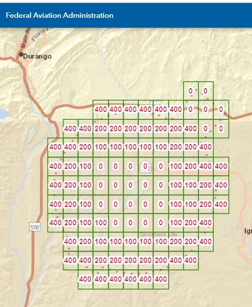
KDRO -- Durango-La Plata County Airport -- Durango CO -- E2 Class-E-to-surface
Old airspace description page E-72 in FAA Joint Order 7400.11A,new airspace description on page E-68 in Joint Order 7400.11E. Effective 09/10/20, the official airport location was moved about 130' to the NW, but more significantly, a new "arm" was added to the Class E airspace, projecting 2 miles to the NE, 2 miles in width. As a result of this new "arm", 7 new squares were added to the LAANC grid, of all which assigned a ceiling of zero. Note the presence of grid squares with a 400' ceiling between the new zero-ceiling grid squares and the airport.
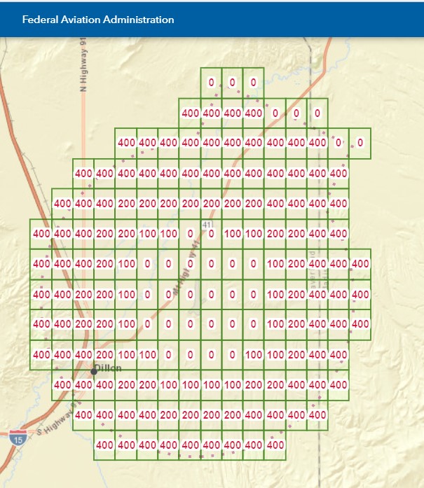
KDLN -- Dillon Airport -- Dillon MT -- E2 Class-E-to-surface -- second attachment
Old airspace description page E-77 in 7400.11A, new airspace description page E-74 in 7400.11E. Effective 9/10/20, the Class E circle was decreased in radius by 0.9 miles, but a new "arm" was also added, 4.8 miles in width and projecting .7 miles beyond the original radius. As a result of this new "arm", 8 new squares were added to the LAANC grid, all of which were assigned a ceiling of zero. Again, note the presence of grid squares with a 400' ceiling between the new zero-ceiling grid squares and the airport.
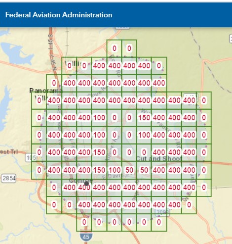
KCXO -- Conroe-North Houston Regional Airport -- Houston, TX -- Class D --third attachment
Old airspace description page D-125 in 7400.11A, new airspace description page D-125 in 7400.11E. Effective 9/10/20, the official location of the airport was shifted about 350' to the NNW, and the radius of the Class D circle was increased by .7 miles (about 3700'). As a result of these changes, 27 new squares were added to the LAANC grid, all of which were assigned a ceiling of zero. Again, note the presence of grid squares with a 400' ceiling between the new zero-ceiling grid squares and the airport.
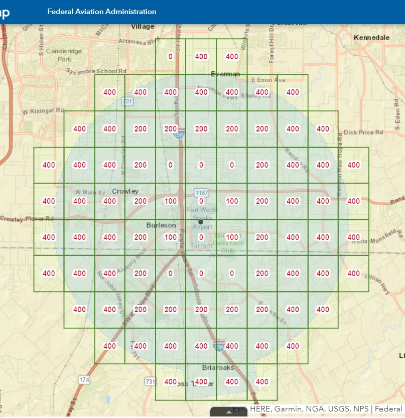
KFWS -- Fort Worth Spinks Airport -- Fort Worth, Texas -- Class D --fourth attachment
Old airspace description page D-129 in 7400.11A, new airspace description page D-125 in 7400.11E. Effective 9/10/20, the official location of the airport was shifted about 85 feet to the west. As a result of these changes, a single new square was added to the LAANC grid, barely penetrated by the new location of the controlled airspace, with an assigned ceiling of "0" AGL. Again, note the presence of grid squares with a 400' ceiling between the new zero-ceiling grid square and the airport.
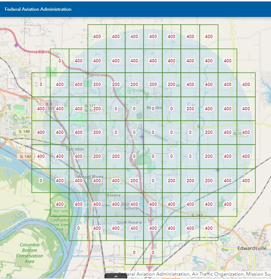
KALN -- St Louis Regional Airport --Alton/St Louis, IL -- Class D
Old airspace description is on page D-31 in 7400.11E, new airspace description is on this page of the Federal Register. page D-125 in 7400.11E. Effective 11/05/20, the Class D airspace was expanded by .2 miles (about 1056 feet), and the center of the circle was shifted about 218' to the southwest due to the change in the official location of the airport. As a result, there are now 6 anomalous zero-ceiling LAANC grid squares running from the south edge of the airspace clockwise around to the northwest edge of the airspace. Note the presence of grid squares with a 400' ceiling between the new zero-ceiling grid squares and the airport.
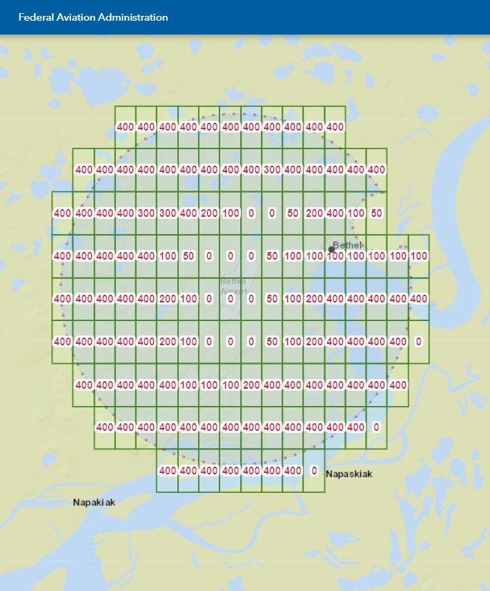
PABE -- Bethel Airport-- Bethel, AK-- Class D
Old airspace description is on page D-3 in 7400.11E, new airspace description is on this page of the Federal Register. page D-125 in 7400.11E. Effective 12/31/20, the Class D circle was shifted about 430' to the southeast due to the change in the official location of the airport. As a result, there are now 3 anomalous zero-ceiling LAANC grid squares at the southeast edge of the airspace. Note the presence of grid squares with a 400' ceiling between the new zero-ceiling grid squares and the airport.
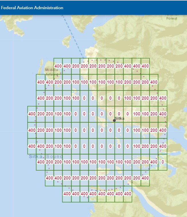
PASI1 -- Sitka Rocky Gutierrez Airport -- Sitka, AK -- E2 Class-E-to-surface airspace
Old airspace description is on page E-9 in 7400.11E, new airspace description is on this page of the Federal Register. Effective 11/05/20, the Class-E-to-surface circle was shifted about 150' to the southeast due to the change in the official location of the airport. As a result, there is now a single anomalous zero-ceiling LAANC grid squares at the ESE edge of the airspace. Note the presence of grid squares with a 400' ceiling between the new zero-ceiling grid squares and the airport.
Footnotes:
- Readers who navigate to the sectional chart for PASI will note that it is error. The chart shows two large projections of the E2 Class-E-to-surface airspace, to the northwest and southwest. Careful scrutiny of the FAA's "Airspace Designations and Reporting Points" documents, JO 7400.11E, shows that those projections are actually E4 Class-E-to-surface "extensions" to the E2 Class-E-to-surface airspace, just as exists at KACV and KTVL. This in fact is the reason that the projections are not covered by the LAANC grid-- the FAA currently construes that no special authorization is required to fly an unmanned aircraft within an E4 "extension". On the sectional chart, the airspace should be depicted with a dashed line separating the "extensions" from the inner circle. For more, see related ASE question What is the primary reason that the non-towered airports ACV, TVL, SGU, BIH, and SIT/PASI have E4 extensions to E2 airspace? . For why this distinction might matter to a pilot of a manned aircraft, see related ASE question What indication has the FAA given that phrases like "surface area of Class E airspace designated for an airport" do or don't include E4 "extensions"? .)

