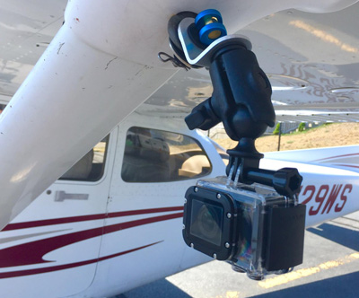
Straight Down is most likely the best angle but there is of course cases to be made for other scenarios. In your case if you are looking for something on the ground that is potentially obstructed a straight down view is going to give you the most direct view and will prevent something from falling out of frame if an angled view cause an obstruction to block it.
The real problem in areal viewing/photography/imaging is the air its self. They touch upon it in this podcast nicely but when it comes to spy satellites (a similar use case) the actual resolvable resolution was limited by the air not the imaging sensor. Its important to go up on a clear day as haze, even VFR legal haze can have a big impact on this.
If you are intending on using a GoPro I might advise getting something with a longer lens (especially if you intend to be at any kind of substantial altitude). For comparison you can check out some of the stuff I have captured with a GoPro here none of that footage was shot over 5000 and most of it below 3000 and it is difficult to pick out smaller objects on the ground in the footage. At the flat mounting angle I use you can see how trees obscure things behind them.
As for mounting bigger lenses, its clearly impractical to point large lenses straight down but there is a work around. Historically spy planes used some kind of mirror set up to look straight down at the ground mounting the large lenses flat in the plane pointed at a mirror.
There are even some smaller GA planes built for this specific purpose with cameras already mounted. Some may simply have a camera trap door. It may be worth it to try and track down this kind of service for your mission.
Your lens choice will also be quite important. The GoPro has a fairly wide lens which offers a great big field of view but considerable edge distortion in actual practice at longer distances. I would advise trying to rent or borrow (unless you own) a decent DSLR with a standard to short-tele lens. On top of that I would not video tape the adventure, I would set the camera to take a series of time laps photos pointed straight down. Most modern cameras can resolve a much higher res image photo than they can video and in the end of the day at a modern frame rate you are going to end up with a log of overkill footage at your given speed. This is how planes like the SR-71 did it back in the day. In this case a decent GPS enabled camera is key, remember you are looking through this data after the fact so you need to know where the picture was actually taken to make it useful.
You also need to think about field of view a bit. The wider the lens the more land you can cover in a single pass at a given altitude but you do so at the cost of angular resolution. The longer the lens the smaller field of view with the benefit of higher angular resolution.
Note: You will find some info out on the web about the use of wide angle lenses in areal imaging. The common ones were the likes of the Zeiss Biogon and Distagon mated to either a custom platform or in the case of the moon missions a Hasselblad body these particular lenses are phenomenally sharp in the edges even wide open. They are however the exception to the rule and most modern wide lenses make trade offs to be compact and light weight. To be safe I would stay away from wide lenses (anything bigger than maybe 28mm on your standard Full Frame SLR) for your trip.
One fairly reasonable option is the variety of mirror reflexive telescope/tele-photo lenses out there. Something like this one could be useful in your endeavor. A few of these have passed through my collection and they are far from great but they do get the job done when you need a big lens in a small package. However I would take a used lens like this one which can be had for the same price any day.
For the sake of a complete answer Im going to add more details although in your specific case they may not apply.
The most successful areal imaging programs quickly adopted stereo imaging setups. In this case 2 cameras were used each mounted slightly off axis of centerline. The Corona program as well as the KH-7 Gambit satellites used such a system with great success. The images when viewed later created a somewhat 3D rendering of the ground which provided superior analysis abilities over the more traditional single camera units. This kind of effect could be achieved with 2 cameras mounted on some kind of bar and a little pre calibration.

