7
$\begingroup$

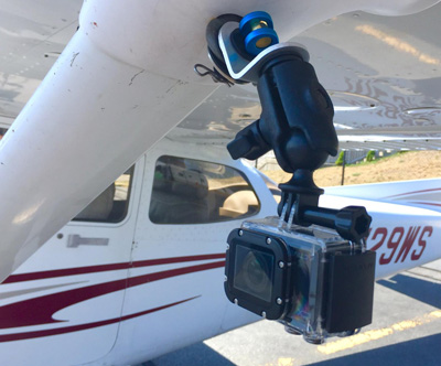
Continuing my series on our upcoming search for a downed Douglas B-18 bomber in Alaska* (13 more days to go!), I've started to think about the angle we should use to "look down" at the terrain. This is especially important because I will be mounting go-pro like cameras on the airplane to capture what we "see" on the ground as we go. I will do this with this handy tie-down mount I came across:

enter image description here

This mount allows the camera's to be positioned at any downward angle. I wouldn't think that either straight down or straight ahead would be optimum...I would assume a good angle would be somewhere in between.

Obviously this question has some relation to photography, and I may also post this question to Photography.SE. However, I would also assume there are a great number of pilots and other aviation professionals with experience searching from airplanes/helicopters for things on the ground.

So my question is, what is the best angle (relative to straight ahead) to search for something on the ground?

Keep in mind that I will be searching over glaciers around an active volcano in partially snow covered terrain.

* Related posts: Where can I find more information about my grandfather's crashed B-18a bomber on Mt. Redoubt Alaska? and What navigational aid(s) would WWII bomber pilots have used while flying in instrument conditions?

$\endgroup$
0

3 Answers 3

6
$\begingroup$

I spent an enormous amount of my childhood & early teens looking out the window of my father's Cessna 337. I found that to look as close to vertically down as possible is actually quite unnatural, the eye will unconsciously keep fixating on details & then whip-panning to the next random detail. The fovea (the surprisingly small area of decent vision our eye has) is designed to continuously move around building up an image & correcting what the brain thought it saw.

Our image of the world is not actually what the eye is looking at, it's what our brain puts together in the visual cortex (optically, it should be upside down for example, but the brain corrects this). Try moving the focus of your gaze, at an even speed, over a patterned carpet from different angles & you'll see what I mean. If your brain doesn't think it's important, it won't bother resolving it properly. Finding your girlfriend's earring in a place you've already looked at eight times is down to how we perceive.

I found it a constant battle to look at areas totally objectively when looking for particular things, and not allowing myself to see just what a part of my brain expects to see. Having a fixed image in your mind of what you're looking for can impede your ability to see a variation of it. I found that it was more tiring the more you limited your scan to straight down, even though it's theoretically closer.

I reckon somewhere between 30-40 degrees from vertical, with constant "situational" general scans. But it needs to be a methodical, yet natural, scan pattern.

As you say, professional military or civil ASR personnel will be the only ones able to answer this properly. They should be able to advise the best relationship between altitude & airspeed for example.

However, video onto uneven snowed landscape probably favours a somewhat more vertical view.

$\endgroup$
6
$\begingroup$

Straight Down is most likely the best angle but there is of course cases to be made for other scenarios. In your case if you are looking for something on the ground that is potentially obstructed a straight down view is going to give you the most direct view and will prevent something from falling out of frame if an angled view cause an obstruction to block it.

The real problem in areal viewing/photography/imaging is the air its self. They touch upon it in this podcast nicely but when it comes to spy satellites (a similar use case) the actual resolvable resolution was limited by the air not the imaging sensor. Its important to go up on a clear day as haze, even VFR legal haze can have a big impact on this.

If you are intending on using a GoPro I might advise getting something with a longer lens (especially if you intend to be at any kind of substantial altitude). For comparison you can check out some of the stuff I have captured with a GoPro here none of that footage was shot over 5000 and most of it below 3000 and it is difficult to pick out smaller objects on the ground in the footage. At the flat mounting angle I use you can see how trees obscure things behind them.

As for mounting bigger lenses, its clearly impractical to point large lenses straight down but there is a work around. Historically spy planes used some kind of mirror set up to look straight down at the ground mounting the large lenses flat in the plane pointed at a mirror.

There are even some smaller GA planes built for this specific purpose with cameras already mounted. Some may simply have a camera trap door. It may be worth it to try and track down this kind of service for your mission.

Your lens choice will also be quite important. The GoPro has a fairly wide lens which offers a great big field of view but considerable edge distortion in actual practice at longer distances. I would advise trying to rent or borrow (unless you own) a decent DSLR with a standard to short-tele lens. On top of that I would not video tape the adventure, I would set the camera to take a series of time laps photos pointed straight down. Most modern cameras can resolve a much higher res image photo than they can video and in the end of the day at a modern frame rate you are going to end up with a log of overkill footage at your given speed. This is how planes like the SR-71 did it back in the day. In this case a decent GPS enabled camera is key, remember you are looking through this data after the fact so you need to know where the picture was actually taken to make it useful.

You also need to think about field of view a bit. The wider the lens the more land you can cover in a single pass at a given altitude but you do so at the cost of angular resolution. The longer the lens the smaller field of view with the benefit of higher angular resolution.

Note: You will find some info out on the web about the use of wide angle lenses in areal imaging. The common ones were the likes of the Zeiss Biogon and Distagon mated to either a custom platform or in the case of the moon missions a Hasselblad body these particular lenses are phenomenally sharp in the edges even wide open. They are however the exception to the rule and most modern wide lenses make trade offs to be compact and light weight. To be safe I would stay away from wide lenses (anything bigger than maybe 28mm on your standard Full Frame SLR) for your trip.

One fairly reasonable option is the variety of mirror reflexive telescope/tele-photo lenses out there. Something like this one could be useful in your endeavor. A few of these have passed through my collection and they are far from great but they do get the job done when you need a big lens in a small package. However I would take a used lens like this one which can be had for the same price any day.


For the sake of a complete answer Im going to add more details although in your specific case they may not apply.

The most successful areal imaging programs quickly adopted stereo imaging setups. In this case 2 cameras were used each mounted slightly off axis of centerline. The Corona program as well as the KH-7 Gambit satellites used such a system with great success. The images when viewed later created a somewhat 3D rendering of the ground which provided superior analysis abilities over the more traditional single camera units. This kind of effect could be achieved with 2 cameras mounted on some kind of bar and a little pre calibration.

$\endgroup$
8
  • 1
    $\begingroup$ The relative angle of the Sun's direction is very important, too... $\endgroup$
    – xxavier
    Commented Aug 11, 2017 at 5:01
  • 1
    $\begingroup$ To put an example; specially when flying low, the accidents on the ground are difficult to see if the visual and the observer-Sun direction form a small angle, and much easier to see with a bigger angle. An extreme case (if not precisely of low level flying...) is the appearance of the Moon's craters, almost invisible at full Moon, when the above-mentioned angle is small, and easily visible with a crescent Moon, when that angle is large... $\endgroup$
    – xxavier
    Commented Aug 11, 2017 at 13:51
  • 1
    $\begingroup$ The higher quality DSLR equipment mentioned is eye-wateringly expensive to buy (though cheap in comparison to plane parts, I'm sure). You can rent high quality equipment for comparatively little, though. Recommendations are typically off topic, so I'll just mention Camera Lens Rentals and Borrow Lenses as places I've used in the past. They also offer high quality, dedicated video equipment, as well. In your situation, I'd opt for purchasing the rental insurance - just in case... ;) $\endgroup$
    – FreeMan
    Commented Aug 11, 2017 at 14:57
  • 1
    $\begingroup$ So... longer shadows makes things easier to see? Is that what all that means? $\endgroup$ Commented Aug 11, 2017 at 17:20
  • 1
    $\begingroup$ @Anyone with experience in flying low, specially in helicopters or in very slow planes knows that there are times of the day and Sun orientations that make it very easy to see objects on the ground, and times of the day and Sun orientations that make that very difficult. The length of the shadows is a factor, but by no means the only one. $\endgroup$
    – xxavier
    Commented Aug 11, 2017 at 18:47
5
$\begingroup$

Another consideration is to look at other aviation sources that perform search and rescue. Civil Air Patrol (CAP) for example, use aircraft routinely to search for aircraft.

A quick read through their Mission Aircrew Reference Text Volume III: Airborne Photographer manual has this to say about the advantages and disadvantages of high and low oblique angles of the target

Low oblique photos only cover a small area, but they do present the photo in detail and present a more natural view. High oblique photos cover a larger area and present a detailed view, but only in the foreground (the detail falls off as you get closer to the horizon).

That being said, they typically are taking pictures of a known disaster or crash site. They do mention though a modification during Hurricane Sandy. Since they didn't know the extent of damage they changed the tactic

The most extreme example is Hurricane Sandy. ...The Maine Wing’s Incident Commander (Col Dan Leclair) stated that this was a “cultural change” in how CAP takes pictures, as they had to photograph everything, regardless of whether there was damage or not. This allowed FEMA to readily pinpoint the areas of greatest need. The aircrews rose to the occasion by flying grid patterns similar to those CAP follows in conducting SAR missions and taking overlapping photos along each leg of the patterns.

Another development they had was about 7 years ago with the introduction of the ARCHER system. I don't know if this is available for purchase from the company that makes the software though.

Basically you tell the ARCHER system what material you're looking for and it tries to find and tag that material as you fly around This wired article explains

called the ARCHER – an acronym for Airborne Real-time Cueing Hyperspectral Enhanced Reconnaissance. The system is capable of panchromatic aerial imaging ... The hyperspectral sensor was built by NovaSol, a Hawaii-based company. 11

A special camera mounted to the belly of the plane transmits detailed images in real time to a flat-screen monitor for operators on the plane to examine... That data is tagged with global-positioning coordinates as well, so searchers can return to an area if ground technicians spot something.

$\endgroup$

You must log in to answer this question.

Not the answer you're looking for? Browse other questions tagged .