8
$\begingroup$

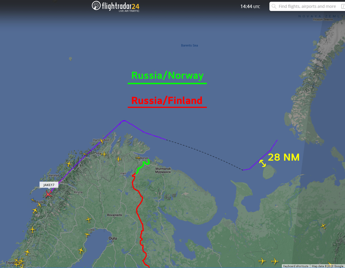
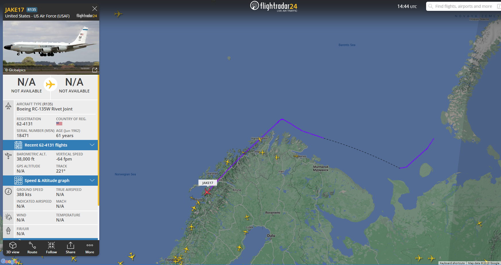
Just encountered this interesting flight on FlightRadar24:

USAF Flight JAKE17

From the path, it looks like it may have "violated", or let's say, been to, russian airspace. Even if not, one has to wonder what kind of mission was performed up there. If it is a spy mission, I would expect the flight to keep the transponder turned off for a longer time?

So, main question is: Is this track inside russian airspace? Bonus question: Any idea what kind of mission takes you up there?

EDIT: Clarification: I do not mean the landmass the aircraft is visibly flying over. That is Norway, I know :-) I meant the proximity to russian islands and the "vector" where transponder info is starting at - but yes, all outside the 12-mile-zone, as I now learnt.

$\endgroup$
3
  • 2
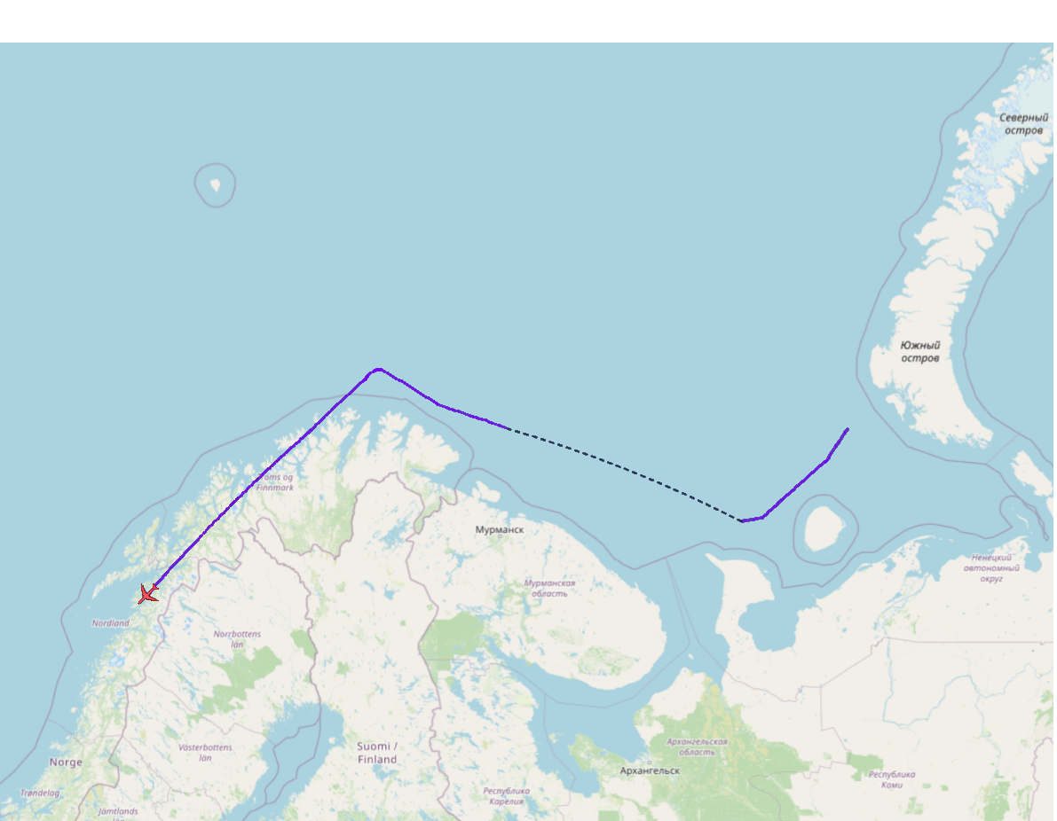
    $\begingroup$ OpenStreetMap shows national waters/airspace boundaries (12 NM) as magenta lines. $\endgroup$
    – Bianfable
    Commented Sep 19, 2023 at 15:17
  • $\begingroup$ Was this a round-trip track starting and ending at the location of the red airplane icon for JAKE17? Or is this showing the end of the track in Norway and the beginning of the track off the big island on the right? $\endgroup$
    – JBH
    Commented Sep 21, 2023 at 15:58
  • $\begingroup$ @JBH The crew seems to have turned on the transponder only where the line starts (or maybe that's where the FR24 coverage starts), and they were still in the air at the time of the screenshot and going southwards. Tracked them for a while (as they were heading roughly in my direction :-)), but not sure at which airbase they eventually landed. $\endgroup$ Commented Sep 22, 2023 at 16:20

3 Answers 3

31
$\begingroup$

Are you possibly thinking that the landmass that the aircraft is flying over is Russian territory? It is actually flying over Norway. In the image below I colored in green the border between Russia and Norway, and in red the border between Russia and Finland.

Russia Norway border

The closest that it got to Russian landmass appears to be about 28 nautical miles (32 miles, 52 km). As mentioned in another answer to your question the limit is 12 nautical miles. And as mentioned in a comment by @Bianfable, OpenStreetMap shows this boundary. Openstreetmaps

$\endgroup$
1
  • 4
    $\begingroup$ As I love Norway, I am very well aware of that country's borders ;-) But yes, I massively overestimated the 12-mile-zone size, and did not think about checking with OpenStreetMap. $\endgroup$ Commented Sep 21, 2023 at 15:03
30
$\begingroup$

Given the scale, that is far outside the 12 mile limit.

What mission? RC-135W Rivet Joint is for monitoring electronic traffic. https://www.af.mil/About-Us/Fact-Sheets/Display/Article/104608/rc-135vw-rivet-joint/

From Wikipedia: "Stated objectives include broadcasting a clear signal that the US, and thus NATO, is aware of Russian movements in the area of operations."

https://en.wikipedia.org/wiki/Boeing_RC-135

And regarding the "awareness", we can frequently see on FR24 other ISR platforms over eastern Poland and Romania. Rivet Joint, JSTARS, AWACS. Tankers to keep them fueled. As well as Global Hawk doing laps over the Black Sea.

What we don't see are all the fighters up there with them. F-15/16/22/35/Typhoon/Eurofighter.

$\endgroup$
2
  • $\begingroup$ Yep, I also frequently see the aircrafts in the mentioned areas, but well, this is a little bit off course here, isn't it? This is why I was also wondering about the mission profile. $\endgroup$ Commented Sep 21, 2023 at 15:05
  • $\begingroup$ This is not the first time I've seen -135RWs up there, on a similar path. $\endgroup$
    – WPNSGuy
    Commented Sep 21, 2023 at 15:20
12
$\begingroup$

Do not mix the exclusive economical zone (EEZ, 200 NM) and the sovereign area. The aircraft has been in the EEZ, not in the sovereign area (12 NM) of the Russian Federation.

EEZ

Yes the aircraft crossed the border of the Russian Federation EEZ. The EEZ extends up to 200 NM from the coastline (even further if there is a continental shelf continuity; Russian Federation tried to use this possibility to extend its EEZ up to the Svalbard archipelago, but it's now resolved).
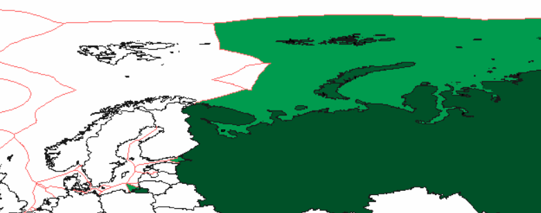
enter image description here

Surce: Wikmedia.

However the airspace over the EEZ is not a sovereign airspace, in fact its entirely free for aircraft.

Sovereign airspace definition

Sovereignty over airspace is limited to 12 NM from the coastline according to Chicago and UNCLOS conventions. UNCLOS defines the limit of the territorial seas, and the Chicago convention states the airspace over territorial seas is sovereign:
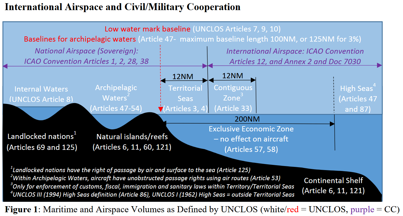
diagram showing extent of air/sea sovereignty etc

Source: ICAO.

Obviously the flight path is not close to this limit at any time.

ADIZ, need to be identified

Unlike the US, the Russian Federation has no official air defense identification zones (the ADIZ concept, which is not part of any international treaty). It means overflying aircraft have no obligation to identify themselves unless they want to enter the sovereign airspace.

EEZ vs sovereign airspace confusion

The EEZ defines important economic rights for activities from the sea surface. However UNCLOS does not grant any right on the airspace over the EEZ (art. 57, 58 and 78). In particular the EEZ adds no restriction for overflying, aircraft are granted all of the rights defined for high sea areas (the seas beyond the EEZ). E.g.:

In the exclusive economic zone, all States, whether coastal or land-locked, enjoy, subject to the relevant provisions of this Convention, the freedoms referred to in article 87 of navigation and overflight and of the laying of submarine cables and pipelines, and other internationally lawful uses of the sea [...]

This confusion seems to be pervasive in the media which often report the "violation" of Taiwanese airspace by China, while these flights are entirely lawful in the EEZ (ignoring the ADIZ which is another topic) as long as the 12 NM national airspace is respected (assuming Taiwan is sovereign, which is indeed disputed).

$\endgroup$

You must log in to answer this question.

Not the answer you're looking for? Browse other questions tagged .