Commonmark migration
Source Link

Example:

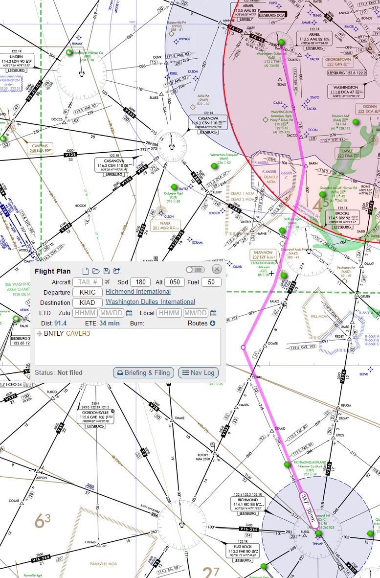
Flying from RIC to IAD, the most popular and "efficient" route is BENTLY -> CAVLR3:

[![enter image description here][1]][1]enter image description here
However, you could more simply depart north out of the RIC Class-D, intercept the BROOKE VOR on the edge of the DC SFRA, and then accept the inevitable vectors from Potomac Approach to IAD:

[![enter image description here][2]][2]enter image description here
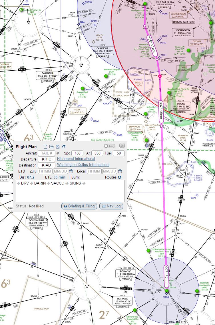
While the time en-route and distance are only trivially shorter, it still illustrates my point: choosing to fly a "non-standard" route is both quicker and potentially easier (without a GPS, hitting the intersections is a more complicated procedure than "direct to BROOKE VOR").

From my training I understand that these airways are primarily used to organize air traffic to reduce risk of collision in uncontrolled airspace as well as to improve flow and organization in controlled.

Which methods (routes/airways vs direct GPS/VOR/DME nav) are more commonly employed by IFR and (vs?) VFR pilots?

Thank you! [1]: https://i.sstatic.net/8oTHZ.jpg [2]: https://i.sstatic.net/kXVmS.jpg

Example:

Flying from RIC to IAD, the most popular and "efficient" route is BENTLY -> CAVLR3:

[![enter image description here][1]][1]

However, you could more simply depart north out of the RIC Class-D, intercept the BROOKE VOR on the edge of the DC SFRA, and then accept the inevitable vectors from Potomac Approach to IAD:

[![enter image description here][2]][2]

While the time en-route and distance are only trivially shorter, it still illustrates my point: choosing to fly a "non-standard" route is both quicker and potentially easier (without a GPS, hitting the intersections is a more complicated procedure than "direct to BROOKE VOR").

From my training I understand that these airways are primarily used to organize air traffic to reduce risk of collision in uncontrolled airspace as well as to improve flow and organization in controlled.

Which methods (routes/airways vs direct GPS/VOR/DME nav) are more commonly employed by IFR and (vs?) VFR pilots?

Thank you! [1]: https://i.sstatic.net/8oTHZ.jpg [2]: https://i.sstatic.net/kXVmS.jpg

Example:

Flying from RIC to IAD, the most popular and "efficient" route is BENTLY -> CAVLR3:

enter image description here

However, you could more simply depart north out of the RIC Class-D, intercept the BROOKE VOR on the edge of the DC SFRA, and then accept the inevitable vectors from Potomac Approach to IAD:

enter image description here

While the time en-route and distance are only trivially shorter, it still illustrates my point: choosing to fly a "non-standard" route is both quicker and potentially easier (without a GPS, hitting the intersections is a more complicated procedure than "direct to BROOKE VOR").

From my training I understand that these airways are primarily used to organize air traffic to reduce risk of collision in uncontrolled airspace as well as to improve flow and organization in controlled.

Which methods (routes/airways vs direct GPS/VOR/DME nav) are more commonly employed by IFR and (vs?) VFR pilots?

Thank you!

Tweeted twitter.com/StackAviation/status/827423183225630721
Source Link

Do GA aircraft pilots use predefined routes (via GPS or DME/VOR vectoring) or methods such as GPS-direct/ VOR-to-VOR in UC airspace?

Example:

Flying from RIC to IAD, the most popular and "efficient" route is BENTLY -> CAVLR3:

[![enter image description here][1]][1]

However, you could more simply depart north out of the RIC Class-D, intercept the BROOKE VOR on the edge of the DC SFRA, and then accept the inevitable vectors from Potomac Approach to IAD:

[![enter image description here][2]][2]

While the time en-route and distance are only trivially shorter, it still illustrates my point: choosing to fly a "non-standard" route is both quicker and potentially easier (without a GPS, hitting the intersections is a more complicated procedure than "direct to BROOKE VOR").

From my training I understand that these airways are primarily used to organize air traffic to reduce risk of collision in uncontrolled airspace as well as to improve flow and organization in controlled.

Which methods (routes/airways vs direct GPS/VOR/DME nav) are more commonly employed by IFR and (vs?) VFR pilots?

Thank you! [1]: https://i.sstatic.net/8oTHZ.jpg [2]: https://i.sstatic.net/kXVmS.jpg