48
$\begingroup$

If the Wright brothers were still alive (and in very good health for their age), could they fly one of their aircraft across the United States today?

Specifically, I'm looking at the Wright Model B, a commercially-produced biplane with a maximum speed of 45 mph, a range of 110 miles, and no radio on board. It was originally produced in 1910, while the first flight across the US (with plenty of stops) was in 1911.

Could a pilot with a Wright Model B use modern airports? Could they navigate? Could they keep to their designated airspace? Could they do all they needed to do to fly in an FAA-approved manner?

$\endgroup$
6
  • 15
    $\begingroup$ there is a flying replica with an FAA registration number $\endgroup$ Commented Jun 3, 2014 at 8:04
  • 2
    $\begingroup$ @ratchetfreak, that's quite a find! $\endgroup$
    – Joe
    Commented Jun 3, 2014 at 8:43
  • 2
    $\begingroup$ it was in the wiki article and I just googled "FAA registry N3786B" $\endgroup$ Commented Jun 3, 2014 at 8:44
  • 3
    $\begingroup$ @ratchetfreak, somehow that didn't occur to me... $\endgroup$
    – Joe
    Commented Jun 3, 2014 at 21:59
  • 4
    $\begingroup$ I'm going to say no, simply due to the aircraft having what I am going to assume is a very low service ceiling thereby rendering impossible a flight across the Rockies or New Mexico. $\endgroup$
    – J W
    Commented Jan 11, 2016 at 14:05

4 Answers 4

59
$\begingroup$

It's possible, but it would be difficult under today's regulations.

Restrictions (regulations):

  1. Avoid any controlled airspace that requires talking to ATC
    For the sake of argument I'll pretend we have no radio on board, so no class B, C, or D airspace.
    (You COULD call the controlling agency and coordinate with them, but let's just pretend we don't have a cell phone either.)

  2. Avoid any airspace within a mode C veil
    Because presumably we don't have a transponder on board we can't cross mode C veils.

  3. Avoid any restricted/special use airspace
    Duh.

  4. Comply with any other restrictions noted on the chart
    I did this in 10 minutes - I may have screwed up a little.

  5. Fuel Reserves
    This is the one that makes it tough.
    With no wind 110 miles at 40MPH (the cruise speed) is ~2.75 hours endurance - I assume that's to empty tanks (which is how it's usually quoted for aircraft).
    The FAA requires at least a 30 minute fuel reserve per FAR 91.151, which means we can fly for 2.25 hours (90 statute miles, 78.2 nautical miles) before we need to land. All legs need to be under that. (It's possible a flight like this could get a waiver from the FAA, but let's assume nobody applied for one.)

Restrictions (Other):

  1. Refueling
    Where possible legs should end at airports that have fuel available.
    (This isn't a hard "must" since presumably the Wright 1B can burn whatever kind of gasoline we can find once we're on the ground).

  2. Airports
    I'm excluding private / restricted airports from consideration as landing spots (again, we'll pretend our pilot has no cell phone and therefore can't coordinate landing access at these fields).

Simplifying Assumptions:

  1. Simple fuel burn
    Not having numbers for this aircraft I'm assuming fuel burn will average out such that the aircraft's endurance on all legs is about 2.75 hours (78.2 nautical miles with no wind). This simplifies the planning

  2. There is no wind
    (Or if there is, it's always a tailwind.)

  3. There's an aviation GPS (or something like Foreflight) onboard
    Frankly I wasn't going to spend an hour looking for landmarks.
    You could probably manage the flight by dead reckoning if you had to though.

  4. The Wright Model B can climb high enough to clear any obstacles/terrain
    Again, not having numbers for the aircraft (service/absolute ceiling) I'm just making the assumption to simplify things.


So if we put all that together can we plan this flight?
What do you think I did with the first half of my lunch hour?

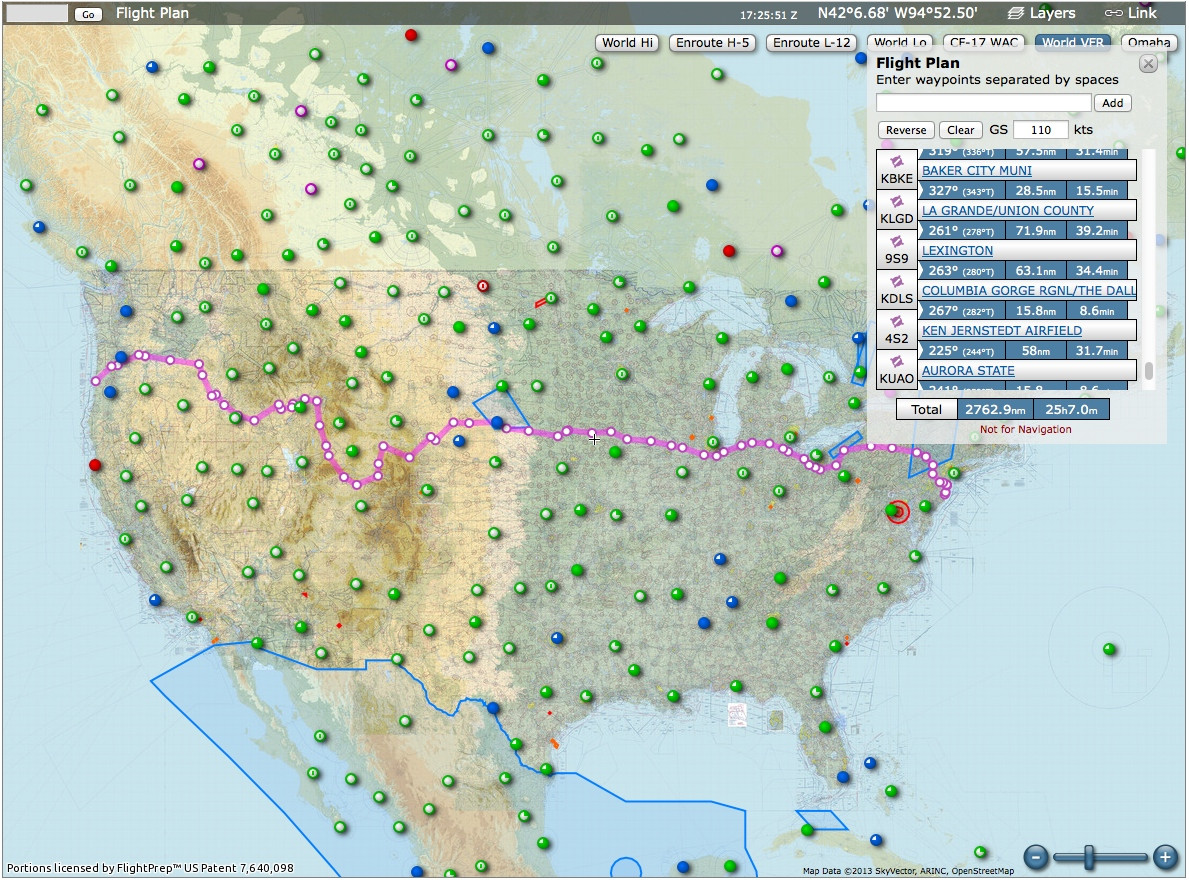
Route Overview
This is one possible route - there may of course be others

I believe I met all the restrictions, if I screwed up I'm sure someone will edit the flight plan (or come up with a different route).


A Note on Performance
As I mentioned in the assumptions I didn't have performance data available for the 1B when I laid out this route. Some folks helpfully pointed out in comments that there are flying replicas of the 1B. These don't appear to be "exact reproduction" replicas, but I was able to find some performance data on them.
Given the maximum altitude in the performance figures (2,000 feet MSL) it would probably not be possible to fly the route plotted above with the reproduction equipment available (several legs are well above 2,000 feet MSL), and I would assume the original 1B had comparable performance.

$\endgroup$
11
  • 1
    $\begingroup$ I'm curious as to the longest leg of that route? How close to the 78.2 nautical mile limit do you cut it? Did you have a program generate the route for you or was it by hand? $\endgroup$ Commented Jun 3, 2014 at 21:04
  • 8
    $\begingroup$ At what altitude do you have it crossing the continental divide? $\endgroup$
    – Gabe
    Commented Jun 4, 2014 at 0:23
  • 2
    $\begingroup$ @MooingDuck I cut it pretty close in at least one spot: The leg between KLCG and KONL is 77.1 nautical miles according to skyvector (it's worth noting however that there are 2 other airports you could stop at to shorten that leg). I also found one error in the route (now corrected in the link above) where I had a leg over the limit for airspace avoidance (around Idaho National Laboratory). I generated this route by hand (I basically picked one east coast airport, one west coast airport, and plotted the great-circle line, then added waypoints as needed to meet the constraints). $\endgroup$
    – voretaq7
    Commented Jun 4, 2014 at 3:15
  • 3
    $\begingroup$ @DavidWilkins you wait out the wind before you lift off of course $\endgroup$ Commented Jun 4, 2014 at 15:16
  • 2
    $\begingroup$ Have you ever tried flying into an airport without a radio? They are normally surprisingly helpful, even at busy (non-class-b) airports! $\endgroup$
    – Lnafziger
    Commented Jun 4, 2014 at 16:53
15
$\begingroup$

You can fly coast to coast without once speaking to ATC or landing in a towered field. Sure, around major cities there are areas where you need a transponder and/or a radio to legally enter but the majority of airspace in the US is still uncontrolled.

In fact, it would be much easier and less risky than in the old days given modern handheld gps units and weather reporting. In the old days there was no weather information, pilots could easily find themselves flying into poor visibility. In the old days there were few reliable road maps, much less anything aviation related, nowdays handheld GPS units and printed charts make navigation simple.

These days you can hop from one airfield to another and know where you are going, how long it will take to get there, and what conditions you can expect along the way. There's also many places to refuel or get maintenance. Personally I think Orville and Wilbur would be pleased with what they would find.

$\endgroup$
4
  • 1
    $\begingroup$ So, in particular, you expect that you'd always be able to stop for more fuel after at most 110 miles? $\endgroup$ Commented Jun 3, 2014 at 15:57
  • $\begingroup$ Not necessarily no. However, you'd have a lot more fuel availability than you would have 100 years ago. To do this for real you may have to plug in a few gaps with some sort of support. $\endgroup$
    – GdD
    Commented Jun 3, 2014 at 16:01
  • 1
    $\begingroup$ You mentioned road maps. Back at that time, there weren't many roads either, hence not many maps. Construction of Interstate Highway System started in 1950s. $\endgroup$
    – Farhan
    Commented Jun 3, 2014 at 18:36
  • 8
    $\begingroup$ @farhan Something something "federal airway system" something something big giant arrow with a light on it. (Filed under: "Obscure stuff you'll probably never need to know in the real world!") $\endgroup$
    – voretaq7
    Commented Jun 3, 2014 at 18:50
15
$\begingroup$

If Orville and Wilbur reappeared today, along with the original Flyer, I expect the FAA would issue an exemption to pretty much everything in about 5 minutes. Also, every pilot in the hemisphere would be watching rather than working thus eliminating the conflicting-traffic issue.

However, they would have a problem starting around 105 West - small geographical inconvenience called the Rocky Mountains. You could possibly pick a route through various valleys but it's unlikely the original design (engine or airfoil) would work at that altitude. And one good gust of wind down the valley will knock it right out of the sky. History might have been quite different if the Wrights were from Denver.

Take the Wrights for a spin in an SR-71 instead.

$\endgroup$
5
  • 3
    $\begingroup$ It's probably easier to find a Wright Model B in flyable condition than an SR-71. $\endgroup$ Commented Jun 5, 2014 at 3:11
  • $\begingroup$ I think NASA / Dryden have a couple, unless they are also in museums. A century-old Flyer B would be very rickety - I'd prefer to build a new one, shouldn't take more than a couple of days. But you were Wilbur/Orville, which would you choose? A ride in your own invention or in the pinnacle of aerospace engineering? $\endgroup$
    – paul
    Commented Jun 5, 2014 at 8:32
  • $\begingroup$ According to SR-71.org the last flight of the NASA SR-71's were in October 1999. According to the same site the Air Force retired theirs in 1990, brought a few back in 1995, and then finally retired them in 1998. As far as "What would you take the Wright's up in - shoot, just about anything would be good. How about a 747 where they could get up, walk around, get a good view, fly across the Pacific...or put 'em in the back set of something like an old F-4, put it vertical, and punch the throttles. Elevator - going UP..! :-) $\endgroup$ Commented Jun 5, 2014 at 10:32
  • 2
    $\begingroup$ Or the back of the An-225 Mriya, with the first flight taped out on the floor. A '71 still looks way cooler than anything we have today. Maybe an F-117, but it can't go Mach 3.3 $\endgroup$
    – paul
    Commented Jun 5, 2014 at 14:20
  • $\begingroup$ They'd get a real kick of E2E Starship if that ever becomes a thing :) $\endgroup$ Commented Jun 18, 2021 at 19:53
2
$\begingroup$

The below answer is probably wrong. I had thought the elevation at the Continental Divide (at least 4421 feet) would be an obstacle. However, according to Wikipedia's list of altitude records, an aircraft described as a "Wright biplane" reached an altitude of 8471 feet in October 1910. It is unclear exactly what model was used, though from the date it was very likely a Model B or some variant thereof. It could have been a Model R, which appears to have been a high-performance variant of the Model B, "designed for speed and altitude competitions"; apparently two examples of the Model R were present at the 1910 International Aviation Tournament where the 8471-foot record was set.

I'll leave this answer here for a couple days for the correction, then delete it.

Original answer:

No, they could not.

Piggybacking on the data found by voretaq7 and following the issue noticed by paul and gabe: according to this data, a similar aircraft has a maximum altitude of about 2000 feet MSL. On the other hand, according to this table, the lowest elevation on the Continental Divide in the US is 4421 feet.

$\endgroup$
2
  • 3
    $\begingroup$ You can't really use that maximum altitude since it is a completely different airplane. From the same page: "Modern engineering and materials were used to design and build an airplane that would look like a Model B but meet modern airworthiness standards. The result was a robust aircraft with a steel structure and a modern aircraft engine. Its empty weight is 3,400 lbs., compared to the 1,400 pound loaded weight of the machine on which it’s based." $\endgroup$
    – Lnafziger
    Commented Jun 5, 2014 at 4:34
  • 2
    $\begingroup$ @Lnafziger: Good point, thanks for noticing that. After further research it appears that Wright aircraft were indeed capable of much higher altitudes; see my edit. $\endgroup$ Commented Jun 5, 2014 at 4:58

You must log in to answer this question.

Not the answer you're looking for? Browse other questions tagged .