m
Source Link
user14897
user14897

One can easily get lost in the alphabet soup that is datalink.

Both ACARS and ADS-B provide datalink applications – which can be broken down in terms of CNS: Communication, Navigation, and Surveillance.

  • ACARS is used for:

  • Communication: includes uplinking (ground → aircraft) weather data upon a downlink request to the company/service provider – not a public service

  • Navigation: if you consider flex-routing

  • Surveillance: position reports in the North Atlantic for example (CPDLC over ACARS).

  • ADS-B is used solely for Surveillance; broadcasting (OUT) own location – and can include ownship surveillance by receiving (IN) traffic information.

  • If this IN setup is via the UAT frequency, then the aircraft can also receive weather information using FIS-B (free service). Its only relation to ADS-B in this particular instance is the UAT frequency, and it is more of a general aviation (and low-flying commercial) service.
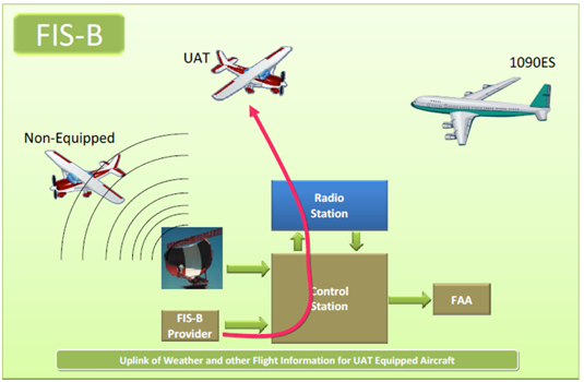
enter image description here
Source: https://www.faa.gov/nextgen/programs/adsb/pilot/#fisb

One can easily get lost in the alphabet soup that is datalink.

Both ACARS and ADS-B provide datalink applications – which can be broken down in terms of CNS: Communication, Navigation, and Surveillance.

  • ACARS is used for:

  • Communication: includes uplinking (ground → aircraft) weather data upon a downlink request to the company/service provider – not a public service

  • Navigation: if you consider flex-routing

  • Surveillance: position reports in the North Atlantic for example.

  • ADS-B is used solely for Surveillance; broadcasting (OUT) own location – and can include ownship surveillance by receiving (IN) traffic information.

  • If this IN setup is via the UAT frequency, then the aircraft can also receive weather information using FIS-B (free service). Its only relation to ADS-B in this particular instance is the UAT frequency, and it is more of a general aviation (and low-flying commercial) service.

enter image description here
Source: https://www.faa.gov/nextgen/programs/adsb/pilot/#fisb

One can easily get lost in the alphabet soup that is datalink.

Both ACARS and ADS-B provide datalink applications – which can be broken down in terms of CNS: Communication, Navigation, and Surveillance.

  • ACARS is used for:

  • Communication: includes uplinking (ground → aircraft) weather data upon a downlink request to the company/service provider – not a public service

  • Navigation: if you consider flex-routing

  • Surveillance: position reports in the North Atlantic for example (CPDLC over ACARS).

  • ADS-B is used solely for Surveillance; broadcasting (OUT) own location – and can include ownship surveillance by receiving (IN) traffic information.

  • If this IN setup is via the UAT frequency, then the aircraft can also receive weather information using FIS-B (free service). Its only relation to ADS-B in this particular instance is the UAT frequency, and it is more of a general aviation (and low-flying commercial) service.

enter image description here
Source: https://www.faa.gov/nextgen/programs/adsb/pilot/#fisb

formatting
Source Link
user14897
user14897

One can easily get lost in the alphabet soup that is datalink.

Both ACARS and ADS-B provide datalink applications – which can be broken down in terms of CNS: Communication, Navigation, and Surveillance.

  • ACARS is used for

    ACARS is used for:

  • Communication: includes uplinking (ground → aircraft) weather data upon a downlink request to the company/service provider – not a public service

    Communication: includes uplinking (ground → aircraft) weather data upon a downlink request to the company/service provider – not a public service

  • Navigation: if you consider flex-routing

    Navigation: if you consider flex-routing

  • Surveillance: position reports in the North Atlantic for example.

    Surveillance: position reports in the North Atlantic for example.

  • ADS-B is used solely for Surveillance; broadcasting (OUT) own location – and can include ownship surveillance by receiving (IN) traffic information, and if this IN setup is based on the UAT frequency, then the aircraft can receive weather information FIS-B (free service). Its only relation to ADS-B in this particular instance is the UAT frequency, and it is more of a general aviation (and low-flying commercial) service.

    ADS-B is used solely for Surveillance; broadcasting (OUT) own location – and can include ownship surveillance by receiving (IN) traffic information.

  • If this IN setup is via the UAT frequency, then the aircraft can also receive weather information using FIS-B (free service). Its only relation to ADS-B in this particular instance is the UAT frequency, and it is more of a general aviation (and low-flying commercial) service.

enter image description here
Source: https://www.faa.gov/nextgen/programs/adsb/pilot/#fisb

One can easily get lost in the alphabet soup that is datalink.

Both ACARS and ADS-B provide datalink applications – which can be broken down in terms of CNS: Communication, Navigation, and Surveillance.

  • ACARS is used for
  • Communication: includes uplinking (ground → aircraft) weather data upon a downlink request to the company/service provider – not a public service
  • Navigation: if you consider flex-routing
  • Surveillance: position reports in the North Atlantic for example.
  • ADS-B is used solely for Surveillance; broadcasting (OUT) own location – and can include ownship surveillance by receiving (IN) traffic information, and if this IN setup is based on the UAT frequency, then the aircraft can receive weather information FIS-B (free service). Its only relation to ADS-B in this particular instance is the UAT frequency, and it is more of a general aviation (and low-flying commercial) service.

enter image description here
Source: https://www.faa.gov/nextgen/programs/adsb/pilot/#fisb

One can easily get lost in the alphabet soup that is datalink.

Both ACARS and ADS-B provide datalink applications – which can be broken down in terms of CNS: Communication, Navigation, and Surveillance.

  • ACARS is used for:

  • Communication: includes uplinking (ground → aircraft) weather data upon a downlink request to the company/service provider – not a public service

  • Navigation: if you consider flex-routing

  • Surveillance: position reports in the North Atlantic for example.

  • ADS-B is used solely for Surveillance; broadcasting (OUT) own location – and can include ownship surveillance by receiving (IN) traffic information.

  • If this IN setup is via the UAT frequency, then the aircraft can also receive weather information using FIS-B (free service). Its only relation to ADS-B in this particular instance is the UAT frequency, and it is more of a general aviation (and low-flying commercial) service.

enter image description here
Source: https://www.faa.gov/nextgen/programs/adsb/pilot/#fisb

m
Source Link
user14897
user14897

One can easily get lost in the alphabet soup that is datalink.

Both ACARS and ADS-B areprovide datalink applications – which can be broken down in terms of CNS: Communication, Navigation, and Surveillance.

  • ACARS is used for
  • Communication: includes uplinking (ground → aircraft) weatherweather data upon a downlink request to the company/service provider – not a public service
  • Navigation: if you consider flex-routing
  • Surveillance: position reports in the North Atlantic for example.
  • ADS-B is used solely for Surveillance; broadcasting (OUT) own location – and can include ownship surveillance by receiving (IN) traffic information, and depending on theif this IN setup is based on the UAT frequency, then the aircraft can receive weatherweather information, which in USA is via the UAT FIS-B (free service). Its only relation to ADS-B in thisin this particular instance is the UAT frequency, and it is more of a general aviation (and low-flying commercial) service.

enter image description here
Source: https://www.faa.gov/nextgen/programs/adsb/pilot/#fisb

One can easily get lost in the alphabet soup that is datalink.

Both ACARS and ADS-B are datalink applications – which can be broken down in terms of CNS: Communication, Navigation, and Surveillance.

  • ACARS is used for
  • Communication: includes uplinking (ground → aircraft) weather data upon a downlink request to the company/service provider – not a public service
  • Navigation: if you consider flex-routing
  • Surveillance: position reports in the North Atlantic for example.
  • ADS-B is used solely for Surveillance; broadcasting (OUT) own location – and can include ownship surveillance by receiving (IN) traffic information, and depending on the IN setup, can receive weather information, which in USA is via the UAT FIS-B (free service). Its only relation to ADS-B in this particular instance is the UAT frequency, and it is more of a general aviation (and low-flying commercial) service.

enter image description here
Source: https://www.faa.gov/nextgen/programs/adsb/pilot/#fisb

One can easily get lost in the alphabet soup that is datalink.

Both ACARS and ADS-B provide datalink applications – which can be broken down in terms of CNS: Communication, Navigation, and Surveillance.

  • ACARS is used for
  • Communication: includes uplinking (ground → aircraft) weather data upon a downlink request to the company/service provider – not a public service
  • Navigation: if you consider flex-routing
  • Surveillance: position reports in the North Atlantic for example.
  • ADS-B is used solely for Surveillance; broadcasting (OUT) own location – and can include ownship surveillance by receiving (IN) traffic information, and if this IN setup is based on the UAT frequency, then the aircraft can receive weather information FIS-B (free service). Its only relation to ADS-B in this particular instance is the UAT frequency, and it is more of a general aviation (and low-flying commercial) service.

enter image description here
Source: https://www.faa.gov/nextgen/programs/adsb/pilot/#fisb

Source Link
user14897
user14897
Loading