0
$\begingroup$

I am studying FAA's airports legacy file and its corresponding layout data. I noticed that runway 13L/31R of JFK Airport lacks a Threshold Crossing Glide Path Height, as one can also confirm from this site. Is there any "standard" value that one can apply here? Neither the official aforementioned legacy file nor any relevant website mention a Visual Glide Path Angle either. In comparison, runway's base end mentions both a Threshold Crossing Glide Path Height (74' AGL) and a Visual Glide Path Angle (3.00 degrees).

I would be grateful if someone could point me in the right direction.

$\endgroup$
7
  • 1
    $\begingroup$ Do you have information on the TDZ (touchdown zone) for the runway and glide path angle? You should be able to calculate the threshold crossing height with those two data points. $\endgroup$
    – Ron Beyer
    Commented Jun 17, 2018 at 21:45
  • $\begingroup$ It provides the Elevation at Touchdown Zone, but no Visual Glide Path or any other relevant values. $\endgroup$ Commented Jun 17, 2018 at 23:09
  • $\begingroup$ I’m curious as to what you’re calling the “base end” $\endgroup$
    – TomMcW
    Commented Jun 18, 2018 at 21:08
  • $\begingroup$ According to the layout of the airports' legacy file, the base end is the "13L" point of the runway, in other words the first point of the runway's segment when it is set to "13L" configuration. From legacy file: "BASE END IDENTIFIER: THE RUNWAY END DESCRIBED BY THE FOLLOWING INFORMATION. RELATES TO THE FIRST PART OF THE RUNWAY IDENTIFICATION (EX. FOR RUNWAY 18/36 THE BASE END IS 18)". $\endgroup$ Commented Jun 19, 2018 at 12:59
  • 1
    $\begingroup$ @VectorZita You can't calculate it with those two points, you need the TDZ (how many feet from the threshold) and the glide path angle. Using some simple trig, you can then calculate the height above the threshold where the glide path crosses. You can't do it with the "TDZ height" because that is the elevation of the TDZ, it has no relation to the distance from the threshold. $\endgroup$
    – Ron Beyer
    Commented Jun 19, 2018 at 18:47

1 Answer 1

1
$\begingroup$

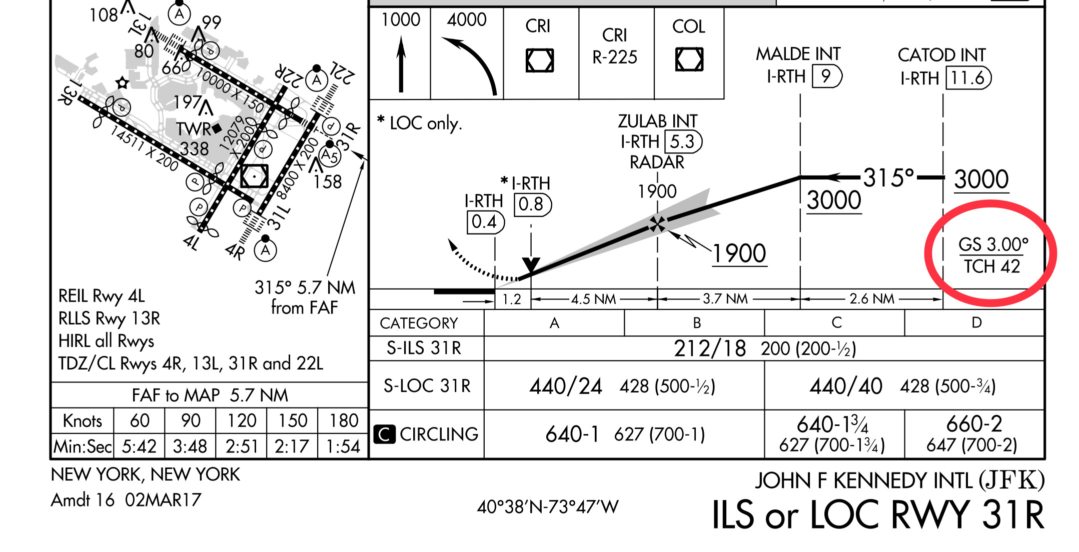
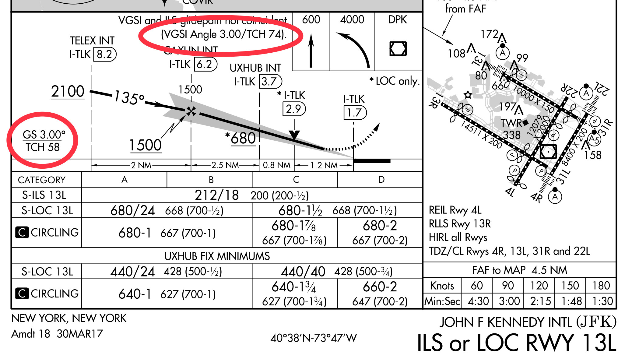
That information is shown on the approach plates

enter image description here

It appears that 31R is not equipped with a VGSI. At least not that I can find. That would be why the data is missing.

enter image description here

On 13L the GS and VGSI are both 3°, but since the VGSI is located about 300ft further down the runway than the GS antenna the TCH is higher.

$\endgroup$
1
  • $\begingroup$ The better question here is why doesn’t 31R have a VGSI. $\endgroup$
    – TomMcW
    Commented Jun 18, 2018 at 22:04

You must log in to answer this question.

Not the answer you're looking for? Browse other questions tagged .