11
$\begingroup$

enter image description here

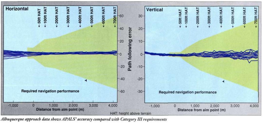
Above shows the performance of a Lockheed Martin civilian landing system developed in the mid-90s. It works by using the weather radar in SAR mode to update the INS, and the final 100 ft are flown by inertial guidance only.

There was interest from American and European carriers, and certification was underway, the rest is unknown. (Rumor has it, an export-embargo was placed due to the sensitivity of the SAR technology.)

Why can't the inertial guidance on its own fly an automatic landing the last 200 ft, thereby saving the CAT II/III installment?

Flying the final 200 ft in 20-30 seconds should have a maximum worst case scenario error of 3-4 m on a 45-60 m wide runway. It should even be better with today's GPS-coupled INS.

The final update before lock-on can happen either via an ILS CAT I or GNSS/SBAS. With a cross-check against stored runway track heading and glide-path angle. Thus eliminating the need for the weather radar and the runway specific SAR data.


RE comments:

  • LM, as shown, has done it in 1996 for the last 100 ft. It was for civilian application.
  • Initialization/alignment is not required, just a position update/check.
$\endgroup$
1
  • 1
    $\begingroup$ There are several reasons for INS drift, but a major one is caused by the curvature of the earth. On flights of even a few hundred miles, the flight over the globe is slowly tipping the nose down in space (compared to it's initial reference) and this creates a substantial error. It may be that civilian aircraft do not or can not take this into account in the same way the military does. $\endgroup$
    – jwzumwalt
    Commented Jan 19, 2018 at 12:08

2 Answers 2

10
$\begingroup$

Suitability for CAT III autoland requires much more than just accuracy. A big factor is system integrity which involves fault detection and alerting. Fault detection in autoland approved ILS/MLS/GLS receivers dual channel processing (command and monitor) with continuous cross-checking and required detection and alerting response times. In the multi-mode receivers (MMR) I've worked on, the monitor tripped if the two channels disagreed by more than 0.0065 DDM for a period of 350 milliseconds. Total time to alert has to be less than 1 second.

To my knowledge, as a result of that requirement GLS has not been approved for less than CAT I approaches as they have not been able to demonstrate the necessary integrity and time to alarm.

I don't know of any method for monitoring an INS system that would be able to meet the requirements. The FMS I work with is capable of detecting and excluding an IRU from the nav solution, but the tolerances are much larger than what would be required for approach and it requires much more than 1 second.

The best reference for what is needed is AC 120-28D. Section 5 covers the Airborne Equipment requirements.

Ultimately, it not only has to work, you have to be able to get it approved. That is not a trivial or inexpensive process, even with published standards. Doing something new, without industry standards, is significantly more difficult. Can you make a business case that would show a long term savings?

$\endgroup$
1
  • $\begingroup$ Third paragraph is probably it. For GLS, I remember reading that auto-land GLS is coming in 2019 or so. $\endgroup$
    – user14897
    Commented Jan 19, 2018 at 18:20
2
$\begingroup$

"the drift of an INS is 650 m after one hour." This means that if you don't even move the airplane, after one hour of just sitting there, the INS can be 650m out. This is of NO USE when trying to find (the middle of) a 50m wide runway.

The INS is good for long-term navigation broad-level accuracy, but not for short-term high-level accuracy. Which is why an INS is usually paired up with some form of radio-updating, be it VOR/DME or DME/DME or GPS or TERCOM.

$\endgroup$
2
  • 2
    $\begingroup$ LM has done it for the last 100 ft in 1996, I am asking about last 200 ft when checked with ILS/GPS. I'm sorry but I don't see how this answers the question. $\endgroup$
    – user14897
    Commented Jan 19, 2018 at 12:05
  • 5
    $\begingroup$ "The INS is good for long-term navigation broad-level accuracy": Actually it isn't, the GPS is. The INS is good for very short term navigation, as it can provide updates at short intervals, something the GPS couldn't until recently (try to drive around a traffic circle without a MEMS INS in the car GPS). Still the GPS is not something so accurate (unless using two frequencies, DGPS, etc), its accuracy is augmented by averaging fix samples. Both combined are good for all types of navigation. $\endgroup$
    – mins
    Commented Jan 19, 2018 at 15:01

You must log in to answer this question.