6
$\begingroup$

Student pilot here, working on my first rating. A lot has been drilled into my head about density altitude as we approach the hot summer months here in the northern hemisphere, and how it causes the plane to act as though it were at a higher altitude—less lift, less power, less thrust—but no one seems to understand when I ask if this also puts the aircraft higher in the sky, as well.

As near as I can understand, the atmosphere actually expands and becomes taller under hot conditions, and the various pressures that we associate with certain altitudes are actually further apart. Is there a flaw in my understanding?

It mystifies me that no one I've talked to seems particularly concerned about something that could potentially throw off your ability to judge your true altitude. Wouldn't you need to be more concerned about cold-weather density altitude when crossing mountain ranges? The mountains don't get shorter just because your pressure levels are closer together . . . right?

$\endgroup$
2
  • 4
    $\begingroup$ Do you understand the difference between height and the different types of altitude? This will help to form an answer. $\endgroup$
    – Simon
    Commented May 22, 2017 at 22:01
  • 5
    $\begingroup$ To be on the safe side, I'm going to say, "no," and hope to learn something. $\endgroup$
    – Aquarello
    Commented May 22, 2017 at 23:07

5 Answers 5

11
$\begingroup$

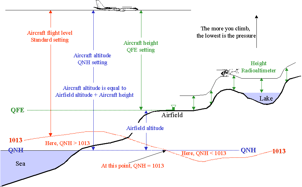
enter image description here
(Source)


The basics

  • Height: absolute height above ground, measured using a radar altimeter (like the helicopter on the right)
  • QFE: the barometric setting an airport broadcasts that makes an altimeter on ground read zero. This gives height only around the airport if the area is relatively flat. Also known as Above Field Elevation
  • QNH: the barometric setting an airport broadcasts that makes an altimeter on ground read the airport's elevation (height above mean sea level)
  • Aircraft using the same QNH below the transition level* in the same area are all flying the same indicated altitudes
  • Aircraft using QNH 1013 mb (29.92 inHg) are all flying the same pressure altitudes. Above the transition altitude* they're called flight levels

* The transition altitudes and levels vary from place to place. For flying below 18,000 feet in the US, you can ignore flight levels for now.

QNH is good for separation since everyone is using the same measurement system. Even if the temperature's rate of change with altitude (lapse rate) is different from the standard.


Lapse rate


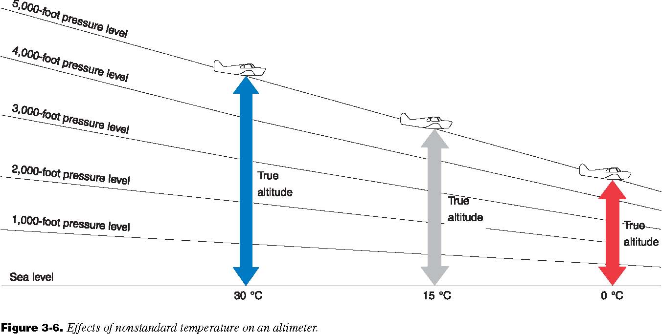
enter image description here
(Source)


On the left is a hotter than usual lapse rate, i.e., it gets colder less slowly. Still, all aircraft using the same pressure setting will still be flying the same indicated altitudes / flight levels.

  • Pressure altitude (what the altimeter reads when set to 1013/29.92) adjusted for lapse rate deviation is density altitude. It's used for performance calculations.

The answer

You said, "[The] atmosphere actually expands and becomes taller under hot conditions".

  1. Yes, but not for that reason. A hotter than standard day means the air molecules are more jumpy, i.e., they are producing more pressure. That's why 1,000 feet on the left is higher. Think of it this way, air is hot, it's still keeping pressure a bit higher (height).

Remember, a basic altimeter senses only pressure from the static port, it doesn't know the temperature.

  1. Since the pressure is the same for the same altitudes, and the variable is the temperature, it will be lower air density on the left due to the higher temperature (angry molecules don't like to cozy up). That's why engine output and lift are impacted.

For cold weather, usually at or below 0°C (32°F), this deviation can become dangerous in mountainous areas. There are special rules and equipment for that, which are listed on the appropriate charts for airports that usually face such conditions.


Further reading:

$\endgroup$
3
$\begingroup$

puts the aircraft higher in the sky

What you are talking about, above your standard altimeter adjustment is altimeter/temperature Error Correction. The article describes when to apply corrections generally speaking and what should be applied. In short pressure altimeters are calibrated for standard lapse rate so if the air temperature changes at a constant rate across an altitude block the altimeter will work just fine. However if you have blocks changing at varying rates you may need to compensate for that.

Generally speaking, the airspace system is designed to prevent this from being an issue. Mountain crossings are done at safe altitudes and when low approaches in such conditions are necessary calibrations are used it may be required to have something like a radar altimeter on board which is not susceptible to this issue.

$\endgroup$
2
$\begingroup$

Density altitude is barometric altitude corrected for nonstandard temperature or pressure. So the Pilots Handbook of Aeronautical Knowledge says but what exactly does that mean?

First remember that an aircraft altimeter is really nothing more than a very sensitive barometer; it simply translates atmospheric pressure readings into those found at a corresponding altitude above seal level. Since air pressure drops by approx 1 inHg for every 1000 feet above MSL, a barometric altimeter becomes an effective means to gauge height above sea level or similar reference datum.

Since the atmosphere varies in both temperature and pressure in different places of the atmosphere around the globe, there exists a need for a standard atmospheric condition to be used as a datum of reference. In SI, this Standard Atmosphere is defined as 1013 millibars (29.92"Hg) at 15°C (59°F) at Mean Sea Level. This standard atmosphere is also a good baseline to calculate performance data for an aircraft at. Charts and performance data are usually created based on an aircraft operating in Standard Atmospheric conditions.

But since ambient atmospheric conditions vary in both temperature and pressure, it is convienent to have a means to convert the ambient air conditions and altitude into an equivalent pressure altitude in standard atmospheric conditions.

Hence this is what Density Altitude is.

Note that Density Altitude has nothing to do with your true altitude or absolute altitude; rather it's an equivalent altitude reading which one would see at STP in the current actual altitude, temperature, and pressure of the air you are currently in.

As an example, suppose you are at Lake Co. Airport in Leadville, Colorado. The field atmosphere here is 9934 ft ASL at 20°C with an altimeter setting of 30.12"Hg. These condition correspond to one you would encounter in air at standard atmospheric conditions at 12,614 ft ASL or gives us a density altitude of 12,614 ft. This doesn't change the fact that you are still only 9934 ft ASL while on the ground in Lake Co. but it does give us a means to quickly use the manufacturer's performance data based on STP to determine the aircraft's performance under these conditions. One would use said charts and compute the performed AS IF the airplane were actually at 12,614 ft at STP versus at 9934 ft in local atmospheric conditions.

Density altitude is of greater importance on hot days than cold ones because the air is less dense when warm than when it is cold. Since both the lift wings can produce at a given true air speed and the power output of an engine are directly proportional to the density of the air, this results in an aircraft which sluggish, even dangerously deficient performance on hot days with high density altitudes than on cold ones with low density altitudes.

$\endgroup$
1
$\begingroup$

No a hot day does not put you higher in the sky, your altimeter just measures a lower air pressure, one that you would find at a higher altitude on a "standard" day.

Density altitude is just that: altitude measured in air pressure (and therefore density), not in feet. It's a convenient but indirect measure of altitude, depending on what we know about how pressure varies with altitude on a standard day.

On a non-standard day, we measure the same pressure at a different altitude, and this is basically what the instructors are talking about:

  • the altimeter needs to be corrected for the non-standard temperature and air pressure at ground level.

  • once this is done, you can find you correct altitude (in feet) at the different air pressure that the instrument is measuring.

Why do we do all this, and not simply just measure altitude directly in feet with a radar altimeter? Because we not only need to know how far away from the ground we are, but also how high other aircraft are, relative to ours, while they're flying over lower or higher terrain.

$\endgroup$
1
$\begingroup$

No. Density Altitude tells you about the air, and more specifically, how your engine and aircraft, lift, will behave in that air.

To punctuate the point, if your plane is at 20 ft above sea level on a cool day, you are at 20 feet. At that same airport, on a very hot day, you are still at 20 feet, but your airplane acceleration will be slower, AND you will need a higher ground speed to achieve the IAS needed to take off.

Now, I'll get a little confusing. I have never liked IAS. It's not about speed, it is about pressure. How much lifting pressure is under the plane. You have a range of pressures. The minimum is your rotation speed. At a certain "air speed", you are moving fast enough through the air to create pressure to lift the plane. VNE is the maximum pressure your plane is designed to take.

When the air is cool and/or the altitude is low, it is thicker. You need less ground speed to reach you IAS rotation speed. When it is hot or high, the air is thinner, provides less lift, so then you need more ground speed to reach your IAS rotation speed.

An illustration of heat, density altitude, happened, last(?) year in Phoenix. The temp got to 116. The airport shut down. Why? Because the jets taking off would have to achieve a higher ground speed to create enough pressure, IAS, under the plane to take off. The takeoff calculations said the jets could not create enough ground speed in the given runway length, to create enough pressure, IAS, to achieve liftoff.

So, again, no. Density Altitude has nothing to do with your actual height above the ground. It DOES have a lot to do with your speed over the ground. On a cool day at sea level, if your rotation speed is 80, your ground speed will be 80. On a very hot day, at the same airport, your ground speed will be higher to achieve 80 IAS.

$\endgroup$

You must log in to answer this question.

Not the answer you're looking for? Browse other questions tagged .