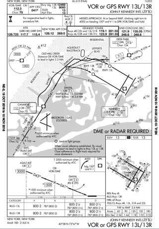
This approach is different than most others, in that it has a fly visual section of the approach, as noted in the lower portion of the plan view:
When visual reference established, fly visual to airport via lead-in lights to Rwy 13L or 13R.
When flying the approach, the pilot must have visual contact with the ground, and be able to maintain visual flight by reference to the ground. Arriving at DMYHL, the flight visibility must be at least two miles, and there must be at least an 800-foot ceiling. Considering that DMYHL is either 2.6 or 3.6 NM from the landing runway, it's entirely legal to continue flight without the runway in sight. Without ground contact and the required visibility and ceiling, a missed approach must be executed at DMYHL.
After passing DMYHL, any time the pilot loses visual contact with the ground, or is unable to fly the Fly Visual path as charted (if, for instance, they could see the ground near them but not the lead-in lights) they must execute the missed approach at that time. Note that continuous ground contact must exist - the lead-in lights could disappear behind a small cloud for 3-5 seconds if the pilots still had the approach path in sight, but the aircraft would not be permitted to enter a cloud after the MAP.
For reference, the AIM contains the following information about Fly Visual segments (AIM 5-4-5(l), page 5-4-19 or 345):
l. In isolated cases, an IAP may contain a published visual flight path. These procedures are
annotated “Fly Visual to Airport” or “Fly Visual.” A
dashed arrow
indicating the visual flight path will be
included in
the profile and plan views with an approximate heading and distance to the end of the runway.
1.
The depicted ground track associated with the
“Fly Visual to Airport” segment should be flown as
a “Dead Reckoning” course. When executing the
“Fly Visual to Airport” segment, the flight visibility
must not be less than that prescribed in the IAP; the
pilot must remain clear of clouds and proceed to the
airport maintaining visual contact with the ground.
Altitude on the visual flight path is at the discretion
of the pilot, and it is the responsibility of the pilot to
visually acquire and avoid obstacles in the “Fly
Visual to Airport” segment.
2.
Missed approach obstacle clearance is
assured only if the missed approach is commenced at
the published MAP. Before initiating an IAP that
contains a “Fly Visual to Airport” segment, the pilot
should have preplanned climb out options based on
aircraft performance and terrain features. Obstacle
clearance is the responsibility of the pilot when the
approach is continued beyond the MAP.
NOTE−
The FAA Administrator retains the authority to approve
instrument approach procedures where the pilot may not
necessarily have one of the visual references specified in
14 CFR
§91.175 and related rules. It is not a function of
procedure
design to ensure compliance with
§91.175. The
annotation “Fly Visual to Airport” provides relief from
§91.175 requirements that the pilot have distinctly visible
and identifiable visual references prior to descent below
MDA/DA.

