4
$\begingroup$

During a standard Instrument Landing System (ILS) approach, I typically arm the VOR/LOC (Boeing 737) to capture the localiser1 once on an intercept course. Upon clearance for the approach, I then arm APP mode to capture the glideslope.

According to my company's Standard Operating Procedures (SOPs), APP mode can only be armed once cleared for the approach and within the Designated Operational Coverage (DOC) of the ILS.

My theory textbooks define ILS coverage as extending "18 NM within 10° of either side of the course centreline and 10 NM within 35° of the course centreline."

Is this the typical DOC that my company SOPs refer to?

Typically, I arm the approach mode approximately 10-12 NM from landing. However, a fellow pilot I flew with recently insisted that APP mode should be no armed further than 10 NM due to DOC. Can someone clarify the typical DOC requirements for ILS approaches

For example, see this NOTAM which describes the DOC into Bergamo as being 25nm/10000ft for IBRM ILS RWY 28:

A4884/24 NOTAMN
Q)LIMM/QIDXX/I/NBO/A/000/999/4540N00942E005
A) LIME
B) 2406121049 C) PERM
E) DME 'IBRM' ASSOCIATED WITH ILS RWY 28 DESIGNATED OPERATIONAL COVERAGE: 25 NM/10000FT REF AIP AD 2 .19 'RADIO NAVIGATION AND LANDING AIDS' COLUMN 7 'DESIGNATED OPERATIONAL COVERAGE LIMITATIONS'


1: American editors, please resist the urge to correct the spelling. I am a British English user and localiser is an acceptable spelling. Thanks 😊

$\endgroup$
4
  • 2
    $\begingroup$ Wouldn't a question about company SOPs be best addressed by someone at your company? $\endgroup$
    – FreeMan
    Commented Jun 18 at 19:18
  • $\begingroup$ @FreeMan While it's true that company SOPs reference the Designated Operational Coverage (DOC), the DOC itself is a standard defined by aviation authorities and not by the company. My question is focused on understanding the typical DOC requirements for ILS approaches, as these are not unique to my company but rather are applicable to aviation operations in general. Clarifying the DOC helps ensure adherence to correct procedures and enhances overall safety. Hence, I'm seeking a broader understanding of DOC in the context of ILS approaches rather than specific company guidelines. $\endgroup$ Commented Jun 21 at 10:58
  • $\begingroup$ Might be best to edit that explanation into the question itself. $\endgroup$
    – FreeMan
    Commented Jun 21 at 11:24
  • $\begingroup$ @FreeMan I do explicitly say that my company SOPs "refer" to DOC. I talk about SOPs to bring context to the area, but DOC is referred to as something outside of the SOPs, and not defined by the company. $\endgroup$ Commented Jun 21 at 12:13

2 Answers 2

1
$\begingroup$

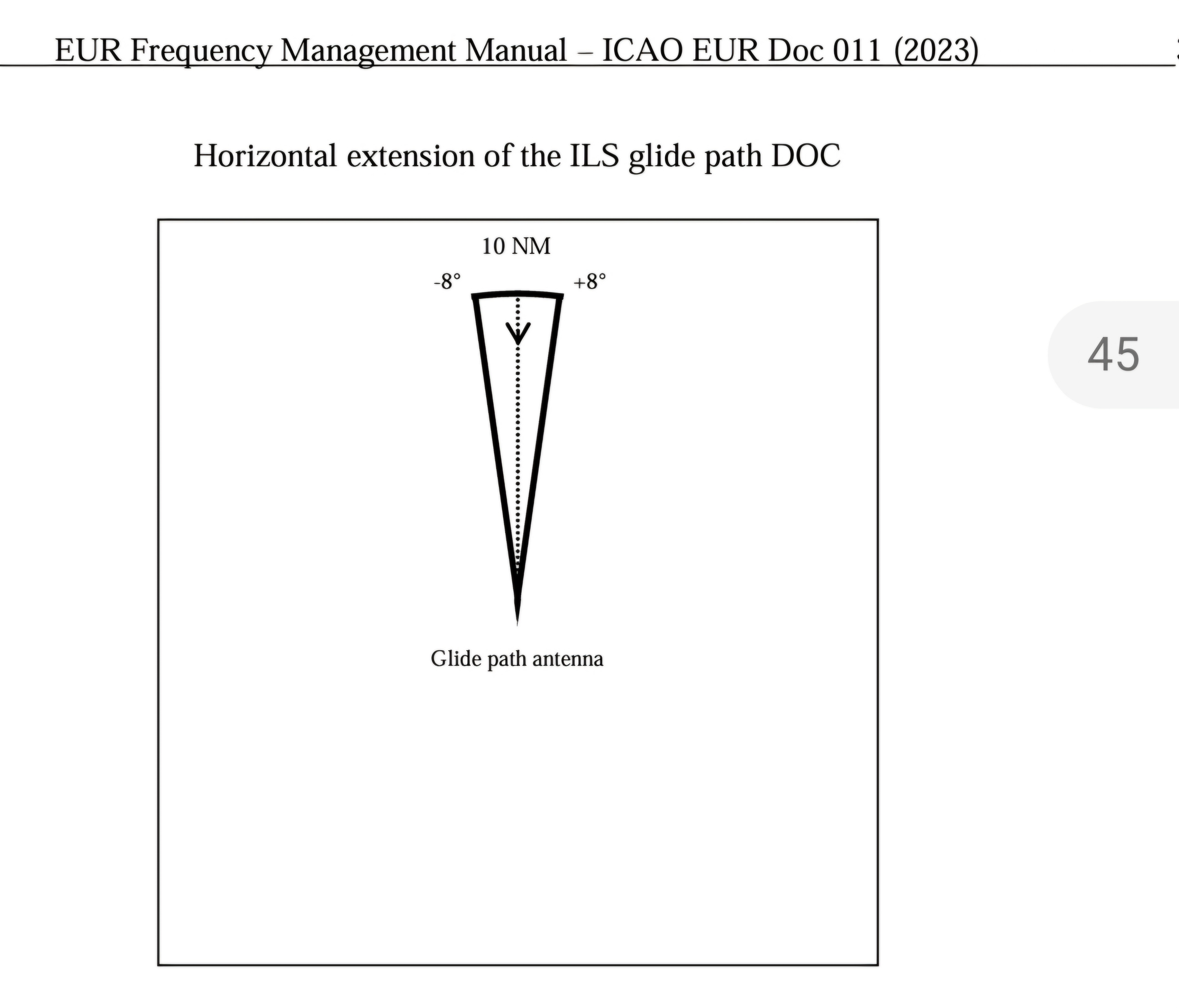
The Designated Operational Coverage area is to protect the ILS frequency from interference by other ILS installations. The DOC is defined in ICAO EUR Doc 11 (Frequency Management Manual).

A DOC is defined for each transmitting component of the ILS; the localiser, the glidepath and the DME.

For arming the APP mode to capture the glide path, the DOC of the glide path is relevant here.

The Glide Path is protected in an area within 8 degrees from the localiser centreline out to a distance of 10NM.

screenshot of the DOC of an ILS glidepath

I believe that supervisory authorities responsible for managing the spectrum and/or verifying the correct functioning of the navaids can define DOCs that are not in line with the standard above. In such case, the actual DOC needs to be published in the AIP.

For example, the German AIP publishes the 'operational coverage' or 'usable' range and sector of navaids associated to an airport in tables of section AIP.AD.2.

$\endgroup$
4
  • $\begingroup$ thanks, though you do see NOTAMs (now added to bottom of the question) suggesting a much higher DOC than 10nm. $\endgroup$ Commented Jun 18 at 16:31
  • 1
    $\begingroup$ @tedioustortoise I suspect that the authorities in charge of frequency protection are allowed to define DOCs that deviate from the standard DOC. I think DOCs are published in the AIP, but I don't know exactly in which section. Note that the NOTAM in your post specifically mentions the DME associated to the ILS, not the ILS itself. The 25NM DOC is thus for the DME, not for the localiser or glidepath; they may have different DOCs. $\endgroup$
    – DeltaLima
    Commented Jun 18 at 21:32
  • $\begingroup$ I just checked the German AIP for Frankfurt (EDDF). In the Aerodrome (AD) section there is a table listing all the navaids associated with the airport and in column 8: Remarks the operational coverage or usable range/sector is described. For the ILSes (both LOC and GP) they all look non-standard. $\endgroup$
    – DeltaLima
    Commented Jun 18 at 21:42
  • $\begingroup$ @tedioustortoise This answer refers to the glide path DOC only, your NOTAM refers to the DME DOC. The localizer DOC is different again (see my answer). $\endgroup$
    – Bianfable
    Commented Jun 19 at 6:03
0
$\begingroup$

The ILS coverage is specified in ICAO Annex 10. What your textbook says corresponds to the reduced localizer coverage already, normal coverage is larger:

3.1.3.3.1 The localizer shall provide signals sufficient to allow satisfactory operation of a typical aircraft installation within the localizer and glide path coverage sectors. The localizer coverage sector shall extend from the centre of the localizer antenna system to distances of:

  • 46.3 km (25 NM) within plus or minus 10 degrees from the front course line;
  • 31.5 km (17 NM) between 10 degrees and 35 degrees from the front course line;
  • 18.5 km (10 NM) outside of plus or minus 35 degrees from the front course line if coverage is provided;

Localizer coverage

except that, where topographical features dictate or operational requirements permit, the limits may be reduced down to 33.3 km (18 NM) within the plus or minus 10-degree sector and 18.5 km (10 NM) within the remainder of the coverage when alternative navigational means provide satisfactory coverage within the intermediate approach area.

Reduced localizer coverage

That is for the localizer, the glide path coverage is smaller, maybe that is what your colleague was referring to:

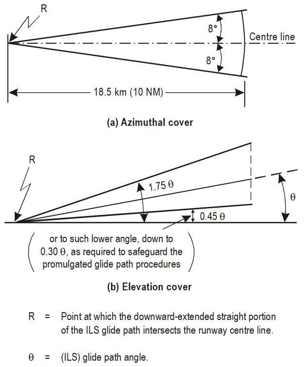
3.1.5.3.1 The glide path equipment shall provide signals sufficient to allow satisfactory operation of a typical aircraft installation in sectors of 8 degrees in azimuth on each side of the centre line of the ILS glide path, to a distance of at least 18.5 km (10 NM) up to 1.75 θ and down to 0.45 θ above the horizontal or to such lower angle, down to 0.30 θ, as required to safeguard the promulgated glide path intercept procedure.

Glide path coverage

$\endgroup$
2
  • $\begingroup$ Thanks. Just to clarify, is this DOC? Operational coverage, and not theoretical coverage? $\endgroup$ Commented Jun 6 at 17:56
  • $\begingroup$ @tedioustortoise ICAO Annex 10 doesn't actually use the term "Designated Operational Coverage" at all, it just defines Coverage. Other ICAO sources (example, see page 4) then use the term DOC for the coverage defined in Annex 10. $\endgroup$
    – Bianfable
    Commented Jun 6 at 18:01

You must log in to answer this question.

Not the answer you're looking for? Browse other questions tagged .