7
$\begingroup$

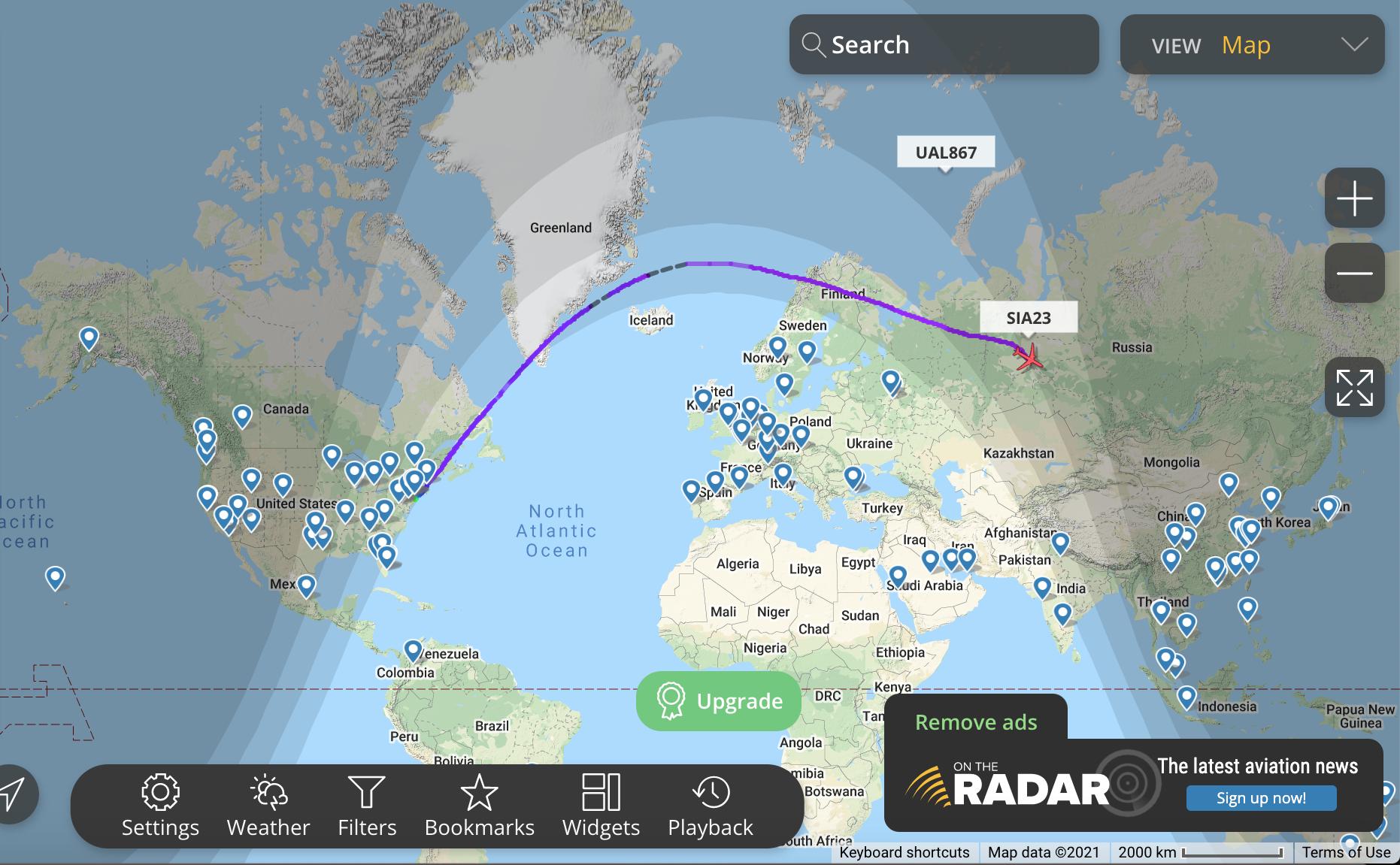
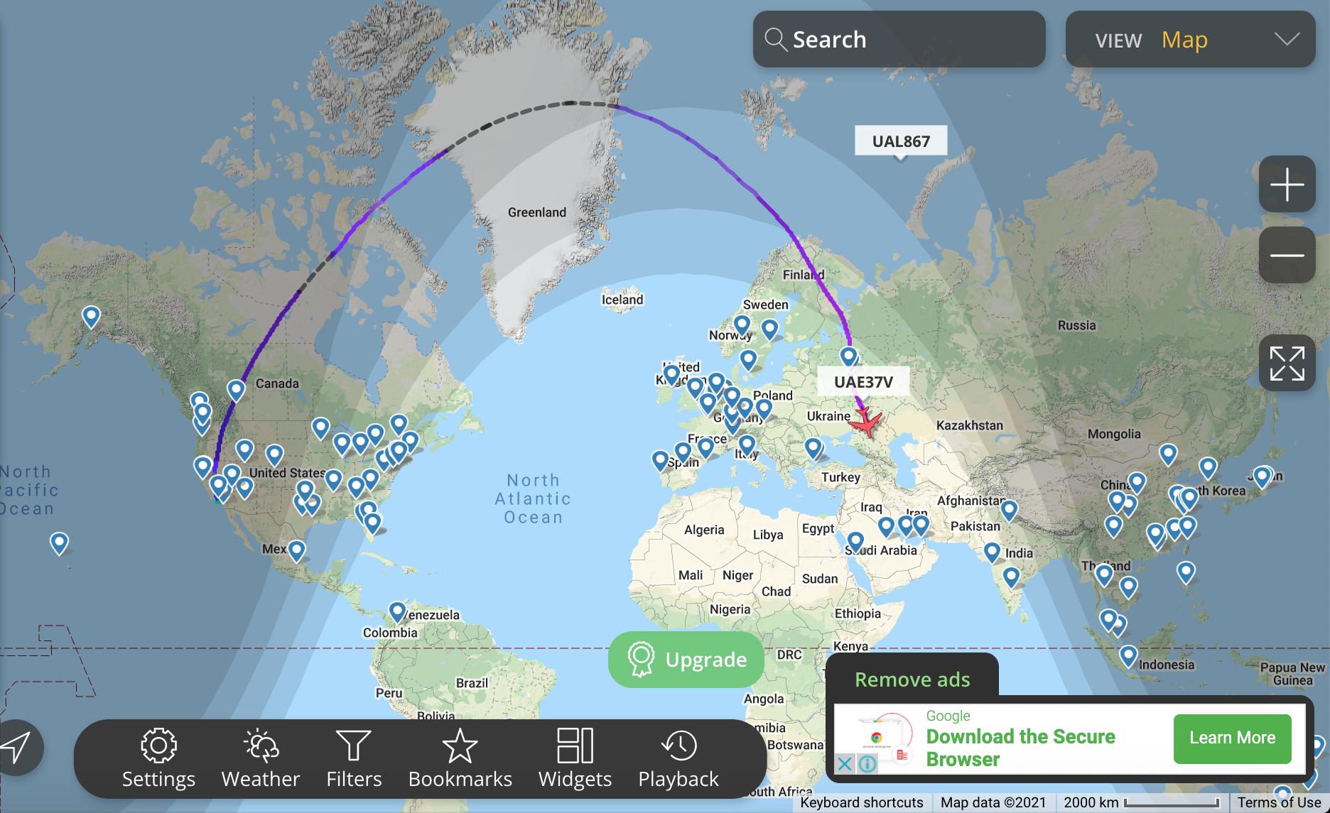
Take a look at these images:

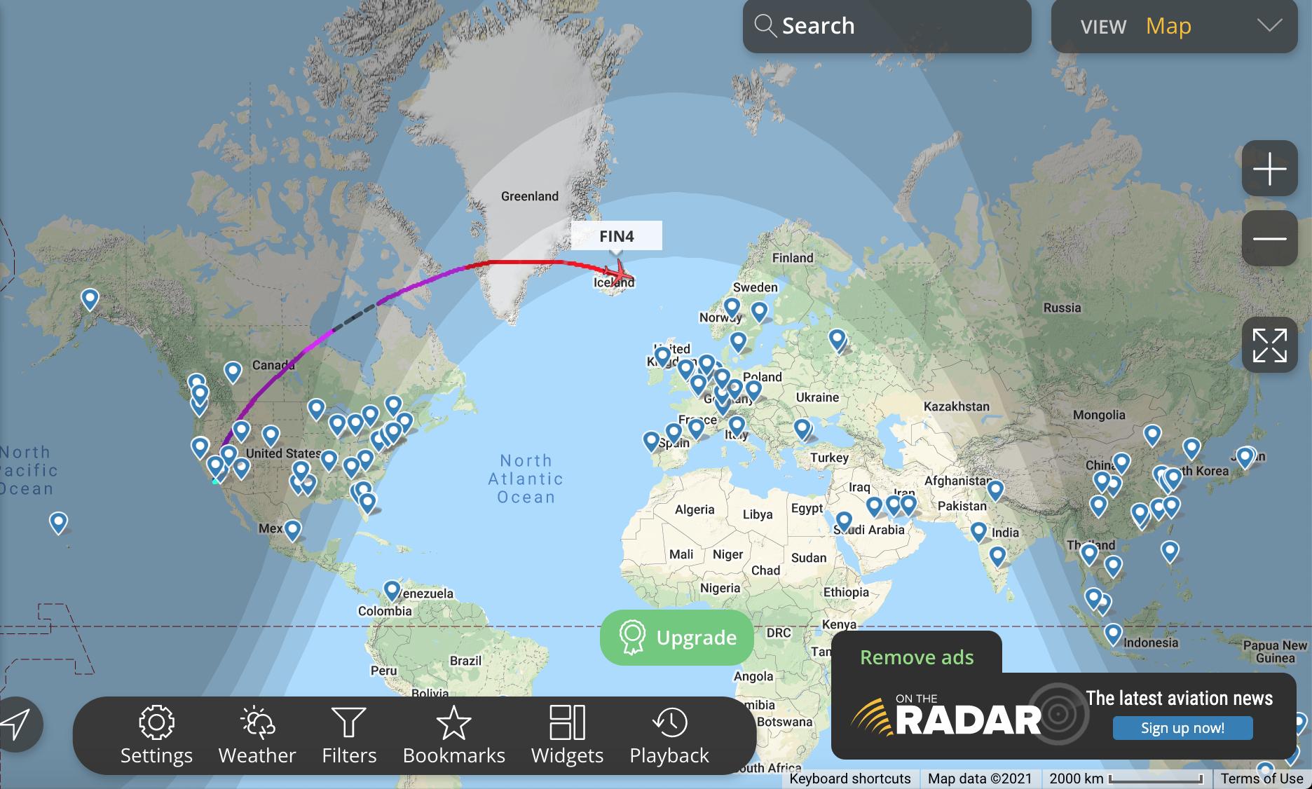
enter image description here

enter image description here

enter image description here

As you can see, in all the images, the flight paths are curved. As far as I know, the shortest path between two points is a straight line. Planes usually would take the shortest path so that they can save fuel, money and time. Then why are the flight paths curved? Why don't planes fly straight to their destination?

$\endgroup$
8
  • 3
  • 29
    $\begingroup$ Because the straight path between two points on a globe leads through the globe. $\endgroup$ Commented Dec 12, 2021 at 15:36
  • 6
    $\begingroup$ I voted to leave open; it's time this got a direct Q&A here. $\endgroup$
    – user14897
    Commented Dec 12, 2021 at 16:01
  • 2
    $\begingroup$ Regardless of the optimal "most direct" route, planes also fly not-directly because there are other airplanes in the sky. ATC will route aircraft in ways that are most efficient for most users while preserving some sense of regularity and order that allows for safety. For example, see this question about arrival and departure gates at busier airports. $\endgroup$
    – randomhead
    Commented Dec 12, 2021 at 16:11
  • 6
    $\begingroup$ It's because the massive nation of Greenland. All that landmass (larger than Africa) houses a secret technological society, which secretly controls the world. By their edicts, all airplanes must fly curved routes. $\endgroup$ Commented Dec 12, 2021 at 22:43

3 Answers 3

54
$\begingroup$

In short

This is counterintuitive. Ignoring Earth curvature not shown on maps, the routes which appear curved on the screenshots are actually nearly straight. Compare these two different projections:
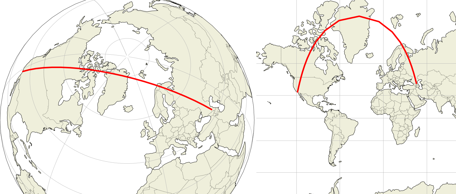
Great circle diagram on sphere and on Mercator map

This is the same track, the same geographic landmarks are crossed. Still:

  • Left: We sense a bulging disk, the path is nearly parallel to two opposite meridians forming a circle, it must be a straight path.

  • Right: The path doesn't seem parallel to any meridian and we can't make sense of the heading change over Greenland. Difficult to see a straight path here.

Websites don't use the azimuthal projection of the left side because the map must be drawn with the path close to the center, while Mercator projection is unique for the whole Earth. But there is a growing demand for an adaptive map representation, adjusting the projection while zooming in/out. With current server and client processing capabilities this is possible, see this demonstration.

Commercial routes are as straight as possible, deviations are due to constraints, e.g. the maximum distance to available emergency airports, weather/conflict unsafe areas and unfavorable winds.

Details follow.


Mercator maps

In 3D, a "straight path" on a sphere is a curve. Our brain is able to identify such curve "as straight" on azimuthal projections, but on other types of map projection, specially on Mercator maps, such equivalence makes no sense. Example with azimuthal projection on the left and web Mercator on the right:
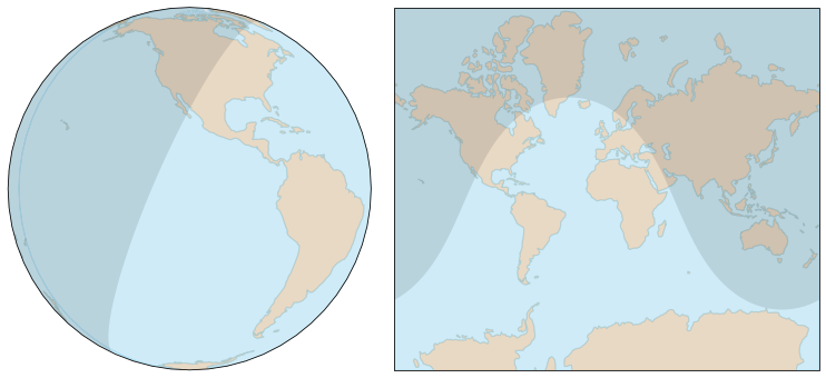
enter image description here

The shadow represents the night, and of course the separation between night and day is a circle, a straight path for an aircraft. It's not difficult to accept the idea the path is straight the left, but on the right, it's nearly impossible. However looking closer, we see the path crosses the same landmarks.

The map on the right side is representative of maps used on websites, a Mercator projection using a cylinder tangent to the equator:
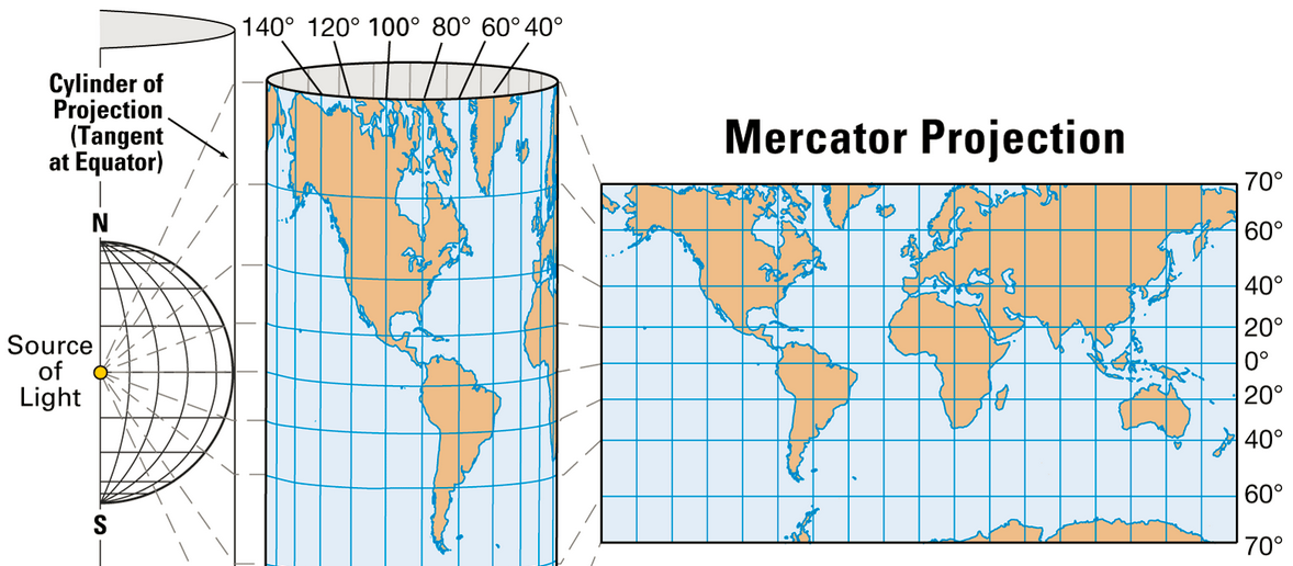
diagram showing Mercator projection rolled into a cylinder round a spherical Earth

Mercator projection, source: Encyclopedia Britannica

The only places the map is accurate is along the equator. At any other latitude, it is distorted, the distortion increasing as we get closer to the poles. It's nonsense near the poles where the meridians never converge, giving Greenland (2 million km²) the size of Africa (30 million km²).

On the image above, features are projected along straight lines. Latitude $\small \phi$ corresponds to map vertical coordinate $\small y(\phi)=r \tan \phi$. Mercator projection actually uses Mercator function, equivalent to $\small y(\phi)=r \ln(\tan(\pi/4+\phi/2))$, in order to make it conformal, the goal Mercator was actually seeking after to make ship navigation easier. The aberrant polar regions are never shown.

Your maps: Los Angeles to Grozny and Dubai

Below is a portion of the great circle from Los Angeles to Grozny, which is approximately the route shown on your last screenshot:

Great circle diagram on sphere and on Mercator map

On the right, the Mercator map shows it curved. Parallels and meridians are circles, note how they have been converted into straight lines. This conversion introduces large distortions:

  • Greenland looks the same size as Africa, see the True Size of Countries to understand how much this is wrong.

  • All great circles except for the equator and meridians are curved, more strongly at higher latitudes.

  • The heading is actually constant, but near the pole, the straight line (great circle) seems to make a U-turn. This is the most counterintuitive aspect.

  • The flat distance for LA-Grozny on the web Mercator projection (EPSG:3857) is 18,300 km, but the real ellipsoidal distance (on WGS 84 ellipsoid) is only about 11,300 km.

This is too much to compensate for, we're not trained for than.

The flight on your last screenshot (UAE37V) was ultimately heading to Dubai. The shortest path would have put it further North than the path it actually used. This is the great circle from LA to Dubai:
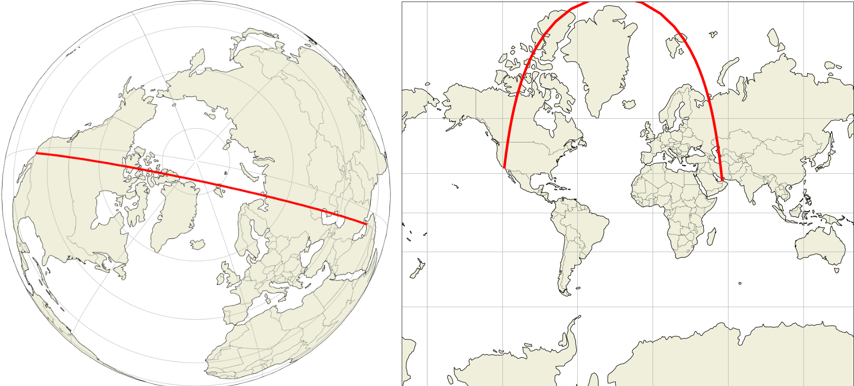
Diagram showing route on sphere and on Mercator projection map

Great circle from LA to Dubai, the shortest route for UAE37V

The projection problem is manifest: the aircraft is following the 120°W meridian then the 60°E meridian. These meridians are (180°) opposite on the globe and form a continuous circle. However, on the Mercator map, this circle is folded at the pole and the two meridians are made parallel lines. So the aircraft seems to turn near the pole, while it actually continues flying straight ahead.

$\endgroup$
8
  • 2
    $\begingroup$ A Mercator projection is not simply 'a projection on a cylinder tangent at equator', because it requires further mathematical elaboration. A simple cylindrical projection tangent to the equator is not conformal, as the Mercator is. math.stackexchange.com/questions/42838/… $\endgroup$
    – xxavier
    Commented Dec 12, 2021 at 18:42
  • 7
    $\begingroup$ @xxavier, for someone just trying grasp the concept of a great circle the question you linked to is frankly a bit much. Because the earth isn't a perfect sphere either. $\endgroup$ Commented Dec 12, 2021 at 22:29
  • 4
    $\begingroup$ @MichaelHall It's close enough to a perfect sphere that you need a very specialist situation for the difference to matter. The difference is about a third of a percent. Coincidentally that's exactly the size of a dimple on a basketball relative to the size of the ball. $\endgroup$
    – Graham
    Commented Dec 13, 2021 at 0:57
  • 1
    $\begingroup$ @Graham, is the difference of a similar magnitude to the Mercator projection not being a "cylindrical projection tangent to the equator"? Because that was my point... $\endgroup$ Commented Dec 13, 2021 at 1:02
  • $\begingroup$ The difference between a Mercator projection and a central cylindrical projection is very important. Pls compare this en.wikipedia.org/wiki/Central_cylindrical_projection and this en.wikipedia.org/wiki/Mercator_projection $\endgroup$
    – xxavier
    Commented Dec 13, 2021 at 7:37
19
$\begingroup$

That is a straight path. It is the map projection being used that is curved.

This is because Earth is a round planet, not a flat surface, and creating accurate maps have always been a problem.

Take a globe and stretch a string between those two points and you will see that it follows the same path as the “curved” lines you have shown.

$\endgroup$
2
  • 7
    $\begingroup$ BREAKING: NORTH AMERICA DEVASTATED BY GIANT STRING, ORIGIN UNKNOWN $\endgroup$
    – Vikki
    Commented Dec 13, 2021 at 5:42
  • $\begingroup$ I am reminded once of a commercial flight where a passenger nearby mentioned to another passenger about being high up enough that they could see the different colors between the states at their borders. Sheesh!!!!! $\endgroup$ Commented Dec 28, 2023 at 21:36
10
$\begingroup$

As you know, Earth is not flat, but is rather close to a sphere.

So "the shortest path between two points is a straight line" does not actually work. The straight line between those two points would go through the Earth, which is quite challenging for most aircraft (!).

The shortest path between two points on a sphere is called the "great circle route". It's the intersection of a plane going through the centre of the sphere and the two points with the surface of the sphere.

Now, mapping a sphere to a flat surface is quite a challenge. Take a soccer ball, cut it in half, and try to lay it fully flat. Good luck. Or try to wrap a basketball with a sheet of paper without any wrinkles or tears. Not going to happen.

There are many different ways of doing that (called projections), which all have different properties, usually trying to conserve either distances or areas or angles, but never all of them at the same time (even though lots of people have tried and some maps are really funky. Just think about the poles: meridians on a sphere all converge to a single point (the pole), while meridians on many maps (and definitely on those you are used to, which use the Mercator or Web Mercator projections like the ones in your exemples) are parallel.

This distorts the representation of the route on the map.

Here's an example, generated with the Great circle mapper.

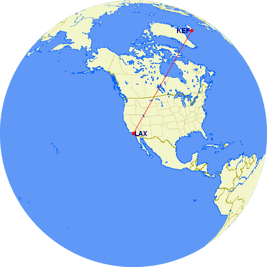
Your first route is roughly LAX to KEF. If you use an orthographic projection it does look like a straight line:

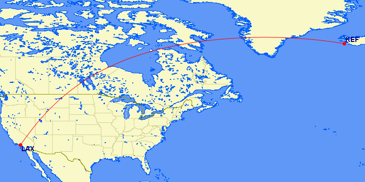
The exact same route, drawn using a rectangular projection, does look curved:

If you look at the points it goes through (e.g. intersections with state or US/CA boundaries or coastlines), you'll see that it's the exact same route, just viewed differently. You'll also see that it's quite close to the route on FR24. The remaining differences may come from:

  • Trying to take advantage of the jet stream (a high-altitude wind which flows west-to-east around those latitudes, which changes a bit all the time, and which can save a lot of time and fuel if you manage to get "pushed" by it as much as possible), or, the other way around, trying to avoid it.
  • Following navigation routes: like you follow roads to go from one place to another, aircraft follow pre-established routes from one waypoint to the next).
  • Avoiding other aircraft (this is actually one of the main goals of the navigation routes above).
  • Avoiding bad weather.
  • In some cases, especially transoceanic routes, making sure the aircraft is never too far from a diversion airport, though nowadays even a twin-engine aircraft can fly quite far from one, see ETOPS.
  • For some routes, avoiding the airpace of some countries, due to local conflicts (aircraft usually don't like flying over war zones which have a risk of stray missiles), or other geopolitical reasons.

A few more examples of routes which are straight but don't like they are:

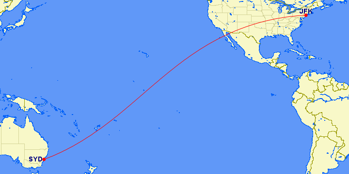
  • JFK-SYD: Note how it looks like it curves one way then the other. The inflexion point is over the equator.

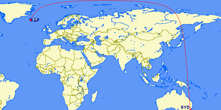
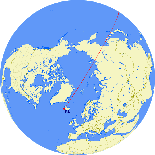
  • KEF-SYD: Yes, it is straight, going over the pole:

$\endgroup$

Not the answer you're looking for? Browse other questions tagged .