GPS faster? Yes and no
GPS is faster depends on which case we want to consider: Cold start, restart or operational use.
Cold start, like for example the first time we use the instrument: Inertial reference systems (IRS) are faster than GPS to deliver the first fix (TTFF): Less than 10 minutes (alignment) against 12.5 minutes for the GPS, the time to receive the constellation almanac from any satellite, a message which is valid for 90 days.
Warm start, like from one day to the next: GPS is faster, on the previous use, it stored the almanac. It now has to get the ephemeris for each satellite in sight, a 12s data transmission repeated every 30s (interleaved with almanac data) and valid for 2 hours. If the restart occurs within 2 hours and ephemerides for satellites in sight where cached, then it takes only a few seconds for the receiver to lock on the satellites data steam and to assess the ionospheric effects on radio signal velocity. IRS initialization takes the same time than for a cold start.
Operational use: IRS is faster, it can deliver a position immediately and continuously when properly aligned, while the GPS may be able to deliver only 10 or 100 updates per second. This parameter is important for fast aircraft, in 0.1s an airliner at M.82 cruises by more than 200m (if you were to use the car navigation system you mentioned in the question, with an update rate of 1s, there would be 2 km between consecutive fixes).
So for day to day operations, IRS is definitely slower to initialize as you observed.
GPS and IRS are not used the same way
We may wonder why these slow IRS are still seen in the plane electronics bay. First, they have two considerable technical advantages:
They are faster to deliver information when aligned. This capability is of prime importance for performance-based operations.
They don't rely on the availability of an external infrastructure to be operational (satellites, monitoring/control stations, SBAS overlays like WAAS, EGNOS, SDCM...) nor on radio transmission. Prior to 2000, the GPS was subject to selective availability under the decision of US generals and it still could suffer from intentional jamming.
But regardless of these advantages, IRS have not the same objectives than GPS. GPS is used to get a position, a Doppler groundspeed and a time reference. Other information, like heading, attitude, linear and angular accelerations, wind vector (with the help of the air data unit), drift angle, all critical data for a large automated aircraft, must be obtained through other sources, the first one being the IRS.
For example the quick determination of attitude parameter is critical for flight envelope protection and yaw damper control. This can only be done with an IRS. When an Airbus aircraft loses its 3 IRS, it loses most of the fly-by-wire protection and the rudder control falls back to mechanical linkage, so the pilot can control yaw with pedals, feel the aerodynamic efforts on rudder and maintain them within acceptable limits, now that yaw rate detection has been lost.
IRS actually provides primary data to various devices like auto-braking (anti-skid), vertical speed indicator or thrust management computer.
This explains why IRS are not going to be removed from electronics bay (it can be INS, IRS, IMU or today combined with air data units like ADIRU). On the other hand as they are subject to continuous drift, their position can be periodically updated by the GPS position (or most likely by a weighted mix of different sources).
Let me detail the principle behind IRS and GPS, and how they are started.
Time to get a fix from an IRS
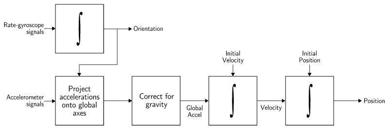
An IRS is composed of 3 accelerometer-gyrometers pairs mutually perpendicular. Gyrometers quantify angular motions, like yaw or roll, and set a frame of reference for the accelerometers. The accelerometers quantity linear motions to update the aircraft position.

Overall principle of a strapdown IRS, source
During alignment the accelerometers sense the sum of gravity acceleration and centripetal acceleration (due to tangential velocity from earth rotation, proportional to latitude) in order to determine the horizontal plane (from the gravity field), true north (from earth rotation axis) and latitude (from centripetal acceleration). But there is a challenge:
Determining pole axis requires knowing the local centripetal acceleration, which in turn depends on latitude, and
determining which part of the locally sensed acceleration is due to latitude (and not to gravity) requires knowing the direction of earth rotation axis (true north). This is numerically solved using successive approximations of both data.
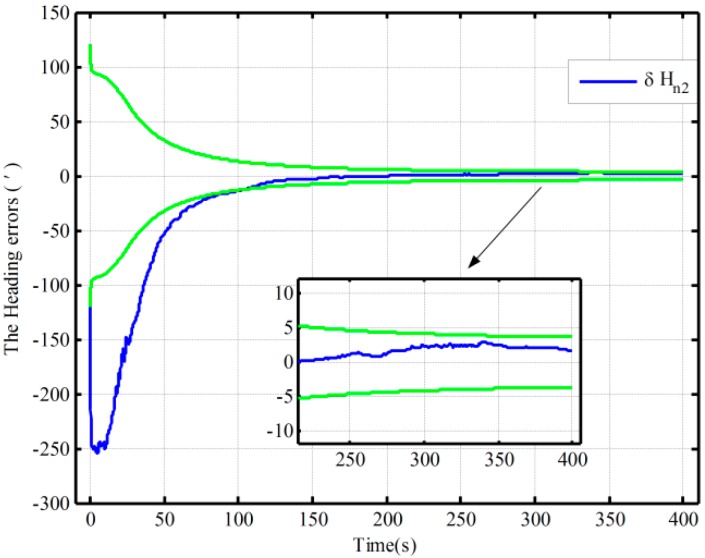
This process is convergent, and both latitude and north direction accuracy increases as the process is extended in time.
The convergence is slow and reaching an operational accuracy indeed requires the long time we know.
The slowness comes from earth rotation produces only tiny effects on the acceleration sensors, and we haven't found more practical sensors yet. The effects depends on the distance from earth rotation axis, larger at the equator than at the poles, hence alignment is also faster at the equator.
Accuracy of true north bearing increases with alignment time:

Source: An Improved Alignment Method for the Strapdown Inertial Navigation System
Alignment requires the unit to be motionless, any erratic motion decreases IRS signal/noise ratio which slows this process (passengers boarding, wind acting on the tail surfaces, etc).
GNSS principle: Need to know the current position of the satellites
To compute a fix, the receiver must know:
- The satellites positions.
- The time it takes for the signal from each satellite to reach the receiver.
... both data with an astronomical precision.
To compute the position, the receiver needs the orbital elements computed on the ground, from control and tracking stations measurements, uploaded to the satellites which act only as relays to broadcast this information along with a time reference from a very accurate embedded clock.
The GNSS receiver then computes the satellite current position along its orbit, and determines the time which has been required for the GPS signal to travel in atmosphere, providing the receiver distance to a known point in space. With 4 satellites and 3D triangulation techniques, the receiver position can be determined.
Satellites parameters are broadcast at different rates:
Rough parameters for all satellites, aka almanacs, valid for 90 days, are transmitted by all satellites every 12.5 minutes (so it may take up to 12.5 minutes to a brand new receiver to deliver the first fix).
Complementary precise parameters for a given satellite, aka ephemeris (which include specific corrections), valid for only two hours are transmitted by this satellite only, every 30 seconds, so it may take up to 30s for a receiver with a valid almanac to provide an accurate fix after restart (if the cached ephemerides for the currently visible satellites are too old), even if a rough fix can be delivered nearly instantaneously.


Regardless of the align method selected, a previously calibrated system requires between 16 and 20 hours to reach specified full navigational accuracy. A system that has not previously completed calibration requires between 68 and 72 hours to reach specified full navigational accuracy.$\endgroup$The actual time required for the system to settle to within specification accuracy is determined by several factors. These include: geographic position, heading and speed of the ship, time of entry and accuracy of first position reset, the alignment method selected, and whether or not the navigation system has been previously calibrated.$\endgroup$