9
$\begingroup$

Airbus is testing a A321 (D-AVXA, flight AIB97XA) around Toulouse this morning. The test is at low altitude, with many speed and altitude changes, including touch and go (maybe rolling slowly on the runway):
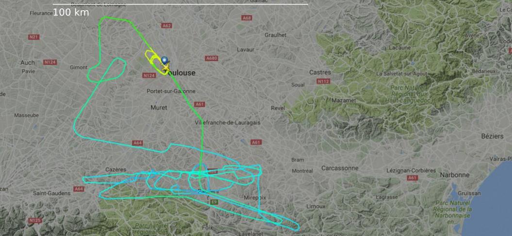
enter image description here
Source: FlightRadar24.

This path crosses other commercial routes / VFR aircraft, and it seems unlikely altitude, speed or even position can be anticipated all the time, but could be determined only while in flight.

All these constraints surely mean a specific treatment from ATC. How does ATC control and coordinate this flight with other aircraft? Toulouse Blagnac (LFBO) is open to commercial flights, and this test flight was within or close to Toulouse TMA.

$\endgroup$
4
  • $\begingroup$ Like all other flights .. they send a flightplan and get a clearance :) Maybe you should try to specify your question $\endgroup$ Commented Sep 19, 2016 at 15:50
  • 1
    $\begingroup$ Sure they can .. ATC is there to provide a service to the pilots, not to limit their options. $\endgroup$ Commented Sep 19, 2016 at 16:39
  • $\begingroup$ At least in the USA, they wouldn't even need to file a plan. They could depart VFR, and operate freely, as long as they obey appropriate speed restrictions (250 kts below 10,000 feet, less in certain airspaces) and stay in VMC conditions. $\endgroup$
    – abelenky
    Commented Sep 19, 2016 at 17:44
  • $\begingroup$ @Federico, Please don't. I had the same feeling before checking, and both forms are used, even on Airbus site. Anyway it seems it comes from GIE Airbus Industrie, an entity that doesn't exist anymore. (a GIE is an alliance in French law.) $\endgroup$
    – mins
    Commented Sep 20, 2016 at 8:25

1 Answer 1

14
$\begingroup$

They will be in contact with ATC at all times and ATC can issue a clearance to operate within a defined area or within a specific flight level range, keeping other aircraft out of that area, e.g.

APP: AIB97XA, cleared for turns and flight level changes in 20NM radius around ABCDE intersection, between FL70 and FL145 at your discretion.

or a bit more standard phraseology:

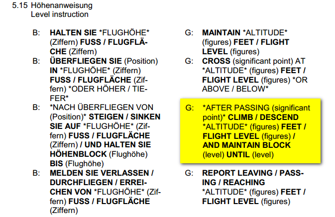
APP: AIB97XA, cleared for turns and flight level changes in 20NM radius around ABCDE intersection and maintain block FL70 until FL145.

From what is visible in the French AIP, the TMA airspace of Toulouse has airspace classes D and C from different altitudes up to FL145, also in the area where your mentioned flight happened.


Phraseology (Source: German NfL 1-251-14 Verfahren Sprechfunk / P. 47)

$\endgroup$
1
  • 2
    $\begingroup$ @mins Cant provide citation for that, but all other flights will be either above FL145 since it is enroute traffic and the adjacent upper CTA controller does not clear aircraft into that airspace to descent, or it will already be below FL70 and under the same ATC unit that the Airbus Test Flight is, so the controller will not assign these level anyway. But yes, any such close or block usage will be coordinated to adjacent sectors. $\endgroup$ Commented Sep 20, 2016 at 0:01

You must log in to answer this question.

Not the answer you're looking for? Browse other questions tagged .