18
$\begingroup$

What tools are being used by airports to measure visibility precisely?

Do we have some kind of tools on aircraft as well for measuring visibility?

$\endgroup$

2 Answers 2

26
$\begingroup$

The visibility is measured alongside the runway, usually at various positions, and is called the Runway Visual Range (RVR).

RVR is defined as the range over which the pilot of an aircraft on the centre line of a runway can see the runway surface markings or the lights delineating the runway or identifying its centre line.

RVR is measured using so called transmissometers.
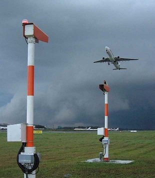
Transmissometer

source: keesfloor.nl

These units transmit a beam of light (usually using laser) to a detector. In some case the transmitter and detector are in the same unit and a reflector is used. The ratio of the transmitted energy and the detected energy is a measure of how much light is absorbed in the fog. From this the RVR can be calculated.

Another type of sensor used to measure the visibility on airports is a forward scatter sensor. This type of sensor can be mounted on a single mast and gives more accurate results for visibilities > 2 km. This kind of sensor is used for both determining RVR and Meteorological Optical Range (MOR).
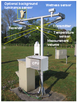
Forward scatter sensor

source: KNMI (PDF)

This type of sensor works by detecting how much of the transmitted light is scattered into a detector which is placed off-axis.


Aircraft don't have means to measure the visibility other than the pilot Mk 1 eyeball.

$\endgroup$
5
  • $\begingroup$ Since light reflects off the water droplets in the air, the forward scatter sensor determines visibility as the inverse of the amount of light detected at the receiver? i.e. more light received means more fog for it to have bounced off of? If not, I'm totally lost on how that would work... $\endgroup$
    – FreeMan
    Commented Jun 19, 2015 at 12:09
  • 2
    $\begingroup$ @FreeMan: That's correct. In perfectly clean air, the off-axis detector would not see any light. $\endgroup$
    – MSalters
    Commented Jun 19, 2015 at 12:18
  • 1
    $\begingroup$ And the other one is, controllers in the tower using fixed distance markers, to show how far they see. $\endgroup$
    – slookabill
    Commented Jun 19, 2015 at 12:35
  • 3
    $\begingroup$ To expand a little: "Ground visibility" and "Flight visibility" are 2 distinct things. Ground is measured as mentioned above, and the sole source of flight visibility is what the pilot reports (measured with above mentioned eyeball)... $\endgroup$ Commented Jun 19, 2015 at 13:26
  • $\begingroup$ Moreover, when ground visibility is reported (automated or observed), a pilot MUST use that. I have been grounded when there is fog over the sensors, but not on the runway. $\endgroup$
    – rbp
    Commented Dec 1, 2015 at 16:03
3
$\begingroup$

To expand on an earlier answer at some towers Controllers use prominent landmarks in the distance to give a rough guide to RVR. They know if they can or cannot see a particular building what the RVR is. This is only used as a last resort when equipment malfunctions, but it works.

$\endgroup$
1
  • $\begingroup$ Great addition! Welcome to Aviation.SE Writerchris. $\endgroup$
    – DeltaLima
    Commented Dec 1, 2015 at 15:21

You must log in to answer this question.

Not the answer you're looking for? Browse other questions tagged .