8
$\begingroup$

The SID chart for Mannheim, Germany (EDFM) runway 27 has segments to OLIVI are not defined in terms of any navigational aids but simply specify a track.

How am I supposed to fly these accurately? And more to the point, how am I supposed to determine that I'm over KOSAX? Dead reckoning? You might think that the SID requires GPS or other RNAV equipment, but there is another chart for that (which is virtually identical, but uses GPS-fix symbols instead of intersections).

KOSAX is also not shown on the Lower Enroute chart, which might otherwise have helped to determine its location.

$\endgroup$
8
  • $\begingroup$ I just know I'm missing the point. What aircraft? What fit? I assume that the GPS/FMC don't understand waypoints? Please add a bit more detail because as the question stands, it seems like 6DME MND then 333 for a bit of dead reckoning. As far as determining the location of KOSAX, why is the lat long not enough? $\endgroup$
    – Simon
    Commented Feb 23, 2015 at 19:17
  • $\begingroup$ @Simon lat/lon would require a GPS or INS or other RNAV equipment do determine accurately (and GPS has its own chart). Given that this is an instrument procedure, I would assume you'd have instrument support to fly it accurately. If you're saying dead-reckoning is the answer, then it's the first instrument procedure using dead-reckoning I've ever come across (not saying it's wrong, just that I didn't know it was acceptable) $\endgroup$
    – falstro
    Commented Feb 23, 2015 at 19:27
  • $\begingroup$ Can't tell from the chart but isn't KOSAX->OLIVI on R294 from MND? What is the text description saying on OLIVI 4W? $\endgroup$
    – Radu094
    Commented Feb 23, 2015 at 19:29
  • $\begingroup$ @Radu094 MND is a DME, no radials available. The text just says to track 333° to KOSAX. But I found the answer in the remarks section of the textual description. $\endgroup$
    – falstro
    Commented Feb 23, 2015 at 19:30
  • 1
    $\begingroup$ Ouch! I see MND now. Well, for that matter how can you fly to 6DME if you have no lateral guidance? Note that all IFR acft are required to have Basic-RNAV in EASA and DR segmments are allowed up to (i believe) 10 or 15 NM $\endgroup$
    – Radu094
    Commented Feb 23, 2015 at 19:32

1 Answer 1

8
$\begingroup$

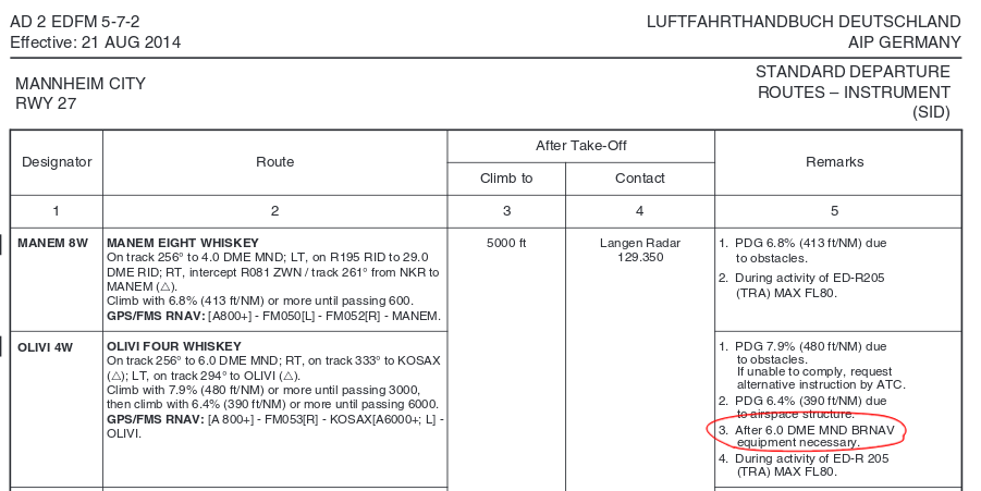
The textual description for OLIVI 4W is:

OLIVI FOUR WHISKEY
On track 256° to 6.0 DME MND; RT, on track 333° to KOSAX;
LT, on track 294° to OLIVI.
Climb with 7.9% (480 ft/NM) or more until passing 3000,
then climb with 6.4% (390 ft/NM) or more until passing 6000.

However, the remarks section holds the answer:

1. PDG 7.9% (480 ft/NM) due to obstacles.
   If unable to comply, request alternative instruction by ATC.
2. PDG 6.4% (390 ft/NM) due to airspace structure.
3. After 6.0 DME MND BRNAV equipment necessary.
4. During activity of ED-R 205 (TRA) MAX FL80.

enter image description here Note "3. After 6.0 DME MND BRNAV equipment necessary."

BRNAV in this case means "Basic RNAV", which is essentially a form of RNAV equipment, but with less stringent certification requirements compared to normal IFR RNAV equipment.

$\endgroup$

You must log in to answer this question.

Not the answer you're looking for? Browse other questions tagged .