wording
Source Link
user14897
user14897

There are many factors that would increase the business cost for taking an operation across the Atlantic/borders:

  • ETOPS
  • Crew accommodation overseas
  • Acquiring airport slots in Europe
  • Aircraft cycles (two flights for one destination)
  • Cruise speed (being 10-12% slower is huge over long distances)
  • Geography, especially latitude.

However, I want towill focus on latitude.the sixth point, latitude. The comparison of types/distances and geography is a key point. 

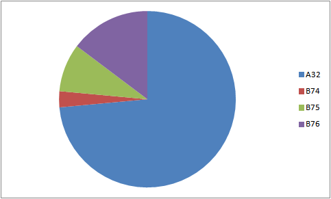
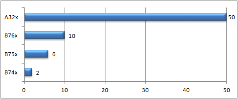
Looking at FlightAware for JFK to LAX from Sat 07:00AM EDT to Sun 10:43PM EDT, and copying the timetable into a spreadsheet, this is the types breakdown:

enter image description here

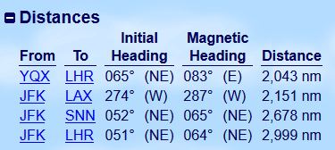
DistancesClearly lots of narrow-bodies on that route. Let's do a distances check:

enter image description here
(gcmap.com)

Ignoring the 5 factors I mentioned,So our best bet is the Gander option, which is 2,043 NM as the crow flies and is comparable to JFK-LAX. Doable, right? Here comes the latitude:

enter image description here
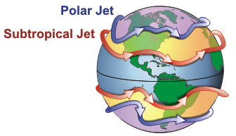
(wikimedia.org)

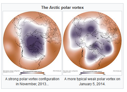
For most of the time, the polar vortex is strong and doesn't affect the contiguous US that much (watch jet stream forecast animation here). When it weakens, this is when the US weather makes international headlines, and the jet stream drops in latitude. In shortSo, for most of the year US transcontinental flights don't face fast headwinds, the story is different for the North Atlantic. – compare below:

enter image description here

When the polar vortex is weak, high pressure zones of the mid latitudes may push poleward, moving the polar vortex, jet stream, and polar front equatorward.

Back to the 2,043 NM distance. We'll add 10% to that for diversion and what not --whatnot – a lenient ballpark figure. Now add 100 knots headwind, and the air distance has become 2,890 NM (at cruise speed of 447 KTAS for the A320).

From the A320 airport planning manual, the 2,000 NM permits almost the full payload of 20 tonnes (181 of 186 seats occupied). 3,000 NM on the other hand drops the utilization to 58%.

Our daring airline will now fly half-empty A320s, has to double the fare because of that, put the passengers through a technical stop, and take at least 80 minutes longer -- because of the polar vortex. Add the other 5 factors, and it's a no-go for low-cost carriers.


One of the A321LR's (aka A321neoLR) key solutions is the additional fuel tanks, 3 in fact and more efficient engines, giving an initial range of 4,000 NM. This range solves the payload problem, and this kind of specialization is a big deal at the moment, which will likelymay render this answer obsoletehistoric in the coming years.

There are many factors that increase the business cost:

  • ETOPS
  • Crew accommodation overseas
  • Acquiring airport slots in Europe
  • Aircraft cycles (two flights for one destination)
  • Cruise speed (being 10-12% slower is huge over long distances).

However, I want to focus on latitude. The comparison of types/distances and geography is a key point. Looking at FlightAware for JFK to LAX from Sat 07:00AM EDT to Sun 10:43PM EDT, and copying the timetable into a spreadsheet, this is the types breakdown:

enter image description here

Distances check:

enter image description here
(gcmap.com)

Ignoring the 5 factors I mentioned, our best bet is the Gander option, which is 2,043 NM as the crow flies and is comparable to JFK-LAX.

enter image description here
(wikimedia.org)

For most of the time, the polar vortex is strong and doesn't affect the contiguous US that much (watch jet stream forecast animation here). When it weakens, this is when the US weather makes international headlines, and the jet stream drops in latitude. In short, for most of the year US transcontinental flights don't face fast headwinds, the story is different for the North Atlantic.

enter image description here

When the polar vortex is weak, high pressure zones of the mid latitudes may push poleward, moving the polar vortex, jet stream, and polar front equatorward.

Back to the 2,043 NM distance. We'll add 10% to that for diversion and what not -- a lenient ballpark figure. Now add 100 knots headwind, and the air distance has become 2,890 NM (at cruise speed of 447 KTAS for the A320).

From the A320 airport planning manual, the 2,000 NM permits almost the full payload of 20 tonnes (181 of 186 seats occupied). 3,000 NM on the other hand drops the utilization to 58%.

Our daring airline will now fly half-empty A320s, has to double the fare because of that, put the passengers through a technical stop, and take at least 80 minutes longer -- because of the polar vortex. Add the other 5 factors, and it's a no-go for low-cost carriers.


One of the A321LR's (aka A321neoLR) key solutions is the additional fuel tanks, 3 in fact, giving an initial range of 4,000 NM. This range solves the payload problem, and this kind of specialization is a big deal at the moment, which will likely render this answer obsolete in the coming years.

There are many factors that would increase the business cost for taking an operation across the Atlantic/borders:

  • ETOPS
  • Crew accommodation overseas
  • Acquiring airport slots in Europe
  • Aircraft cycles (two flights for one destination)
  • Cruise speed (being 10-12% slower is huge over long distances)
  • Geography, especially latitude.

I will focus on the sixth point, latitude. The comparison of types/distances and geography is a key point. 

Looking at FlightAware for JFK to LAX from Sat 07:00AM EDT to Sun 10:43PM EDT, and copying the timetable into a spreadsheet, this is the types breakdown:

enter image description here

Clearly lots of narrow-bodies on that route. Let's do a distances check:

enter image description here
(gcmap.com)

So our best bet is the Gander option, which is 2,043 NM as the crow flies and is comparable to JFK-LAX. Doable, right? Here comes the latitude:

enter image description here
(wikimedia.org)

For most of the time, the polar vortex is strong and doesn't affect the contiguous US that much (watch jet stream forecast animation here). When it weakens, this is when the US weather makes international headlines, and the jet stream drops in latitude. So, for most of the year US transcontinental flights don't face fast headwinds, the story is different for the North Atlantic – compare below:

enter image description here

When the polar vortex is weak, high pressure zones of the mid latitudes may push poleward, moving the polar vortex, jet stream, and polar front equatorward.

Back to the 2,043 NM distance. We'll add 10% to that for diversion and whatnot – a lenient ballpark figure. Now add 100 knots headwind, and the air distance has become 2,890 NM (at cruise speed of 447 KTAS for the A320).

From the A320 airport planning manual, the 2,000 NM permits almost the full payload of 20 tonnes (181 of 186 seats occupied). 3,000 NM on the other hand drops the utilization to 58%.

Our daring airline will now fly half-empty A320s, has to double the fare because of that, put the passengers through a technical stop, and take at least 80 minutes longer because of the polar vortex. Add the other 5 factors, and it's a no-go for low-cost carriers.


One of the A321LR's (aka A321neoLR) key solutions is the additional fuel tanks and more efficient engines, giving an initial range of 4,000 NM. This range solves the payload problem, and this kind of specialization is a big deal at the moment, which may render this answer historic in the coming years.

chart
Source Link
user14897
user14897

There are many factors that increase the business cost:

  • ETOPS
  • Crew accommodation overseas
  • Acquiring airport slots in Europe
  • Aircraft cycles (two flights for one destination)
  • Cruise speed (being 10-12% slower is huge over long distances).

However, I want to focus on latitude. The comparison of types/distances and geography is a key point. Looking at FlightAware for JFK to LAX from Sat 07:00AM EDT to Sun 10:43PM EDT, and copying the timetable into a spreadsheet, this is the types breakdown:

enter image description hereenter image description here

Distances check:

enter image description here
(gcmap.com)

Ignoring the 5 factors I mentioned, our best bet is the Gander option, which is 2,043 NM as the crow flies and is comparable to JFK-LAX.

enter image description here
(wikimedia.org)

For most of the time, the polar vortex is strong and doesn't affect the contiguous US that much (watch jet stream forecast animation here). When it weakens, this is when the US weather makes international headlines, and the jet stream drops in latitude. In short, for most of the year US transcontinental flights don't face fast headwinds, the story is different for the North Atlantic.

enter image description here

When the polar vortex is weak, high pressure zones of the mid latitudes may push poleward, moving the polar vortex, jet stream, and polar front equatorward.

Back to the 2,043 NM distance. We'll add 10% to that for diversion and what not -- a lenient ballpark figure. Now add 100 knots headwind, and the air distance has become 2,890 NM (at cruise speed of 447 KTAS for the A320).

From the A320 airport planning manual, the 2,000 NM permits almost the full payload of 20 tonnes (181 of 186 seats occupied). 3,000 NM on the other hand drops the utilization to 58%.

Our daring airline will now fly half-empty A320s, has to double the fare because of that, put the passengers through a technical stop, and take at least 80 minutes longer -- because of the polar vortex. Add the other 5 factors, and it's a no-go for low-cost carriers.


One of the A321LR's (aka A321neoLR) key solutions is the additional fuel tanks, 3 in fact, giving an initial range of 4,000 NM. This range solves the payload problem, and this kind of specialization is a big deal at the moment, which will likely render this answer obsolete in the coming years.

There are many factors that increase the business cost:

  • ETOPS
  • Crew accommodation overseas
  • Acquiring airport slots in Europe
  • Aircraft cycles (two flights for one destination)
  • Cruise speed (being 10-12% slower is huge over long distances).

However, I want to focus on latitude. The comparison of types/distances and geography is a key point. Looking at FlightAware for JFK to LAX from Sat 07:00AM EDT to Sun 10:43PM EDT, and copying the timetable into a spreadsheet, this is the types breakdown:

enter image description here

Distances check:

enter image description here
(gcmap.com)

Ignoring the 5 factors I mentioned, our best bet is the Gander option, which is 2,043 NM as the crow flies and is comparable to JFK-LAX.

enter image description here
(wikimedia.org)

For most of the time, the polar vortex is strong and doesn't affect the contiguous US that much (watch jet stream forecast animation here). When it weakens, this is when the US weather makes international headlines, and the jet stream drops in latitude. In short, for most of the year US transcontinental flights don't face fast headwinds, the story is different for the North Atlantic.

enter image description here

When the polar vortex is weak, high pressure zones of the mid latitudes may push poleward, moving the polar vortex, jet stream, and polar front equatorward.

Back to the 2,043 NM distance. We'll add 10% to that for diversion and what not -- a lenient ballpark figure. Now add 100 knots headwind, and the air distance has become 2,890 NM (at cruise speed of 447 KTAS for the A320).

From the A320 airport planning manual, the 2,000 NM permits almost the full payload of 20 tonnes (181 of 186 seats occupied). 3,000 NM on the other hand drops the utilization to 58%.

Our daring airline will now fly half-empty A320s, has to double the fare because of that, put the passengers through a technical stop, and take at least 80 minutes longer -- because of the polar vortex. Add the other 5 factors, and it's a no-go for low-cost carriers.


One of the A321LR's (aka A321neoLR) key solutions is the additional fuel tanks, 3 in fact, giving an initial range of 4,000 NM. This range solves the payload problem, and this kind of specialization is a big deal at the moment, which will likely render this answer obsolete in the coming years.

Mod Moved Comments To Chat
grammar
Source Link
user14897
user14897

There are many factors that increase the business cost:

  • ETOPS
  • Crew accommodation overseas
  • Acquiring airport slots in Europe
  • Aircraft cycles (two flights for one destination)
  • Cruise speed (being 10-12% slower is huge over long distances).

However, I want to focus on latitude. The comparison of types/distances and geography is a key point. Looking at FlightAware for JFK to LAX from Sat 07:00AM EDT to Sun 10:43PM EDT, and copying the timetable into a spreadsheet, this is the types breakdown:

enter image description here

Distances check:

enter image description here
(gcmap.com)

Ignoring the 5 factors I mentioned, our best bet is the Gander option, which is 2,043 NM as the crow flies and is comparable to JFK-LAX.

enter image description here
(wikimedia.org)

For most of the time, the polar vortex is strong and doesn't affect the contiguous US that much (watch jet stream forecast animation here). When it weakens, this is when the US weather makes international headlines, and the jet stream drops in latitude. In short, for most of the year US transcontinental flights don't face fast headwinds, the story is different for the North Atlantic.

enter image description here

When the polar vortex is weak, high pressure zones of the mid latitudes may push poleward, moving the polar vortex, jet stream, and polar front equatorward.

Back to the 2,043 NM distance. We'll add 10% to that for diversion and what not -- a lenient ballpark figure. Now add 100 knots headwind, and the air distance has become 2,890 NM (at cruise speed of 447 KTAS for the A320).

From the A320 airport planning manual, the 2,000 NM permits almost the full payload of 20 tonnes (181 of 186 seats occupied). 3,000 NM on the other hand drops the utilization to 58%.

Our daring airline will now fly half-empty A320s, has to double the fare because of that, and put the passengers through a technical stop, and take at least 80 minutes morelonger -- because of the polar vortex. Add the other 5 factors, and it's a no-go for low-cost carriers.


One of the A321LR's (aka A321neoLR) key solutions is the additional fuel tanks, 3 in fact, giving an initial range of 4,000 NM. This range solves the payload problem, and this kind of specialization is a big deal at the moment, which will likely render this answer obsolete in the coming years.

There are many factors that increase the business cost:

  • ETOPS
  • Crew accommodation overseas
  • Acquiring airport slots in Europe
  • Aircraft cycles (two flights for one destination)
  • Cruise speed (being 10-12% slower is huge over long distances).

However, I want to focus on latitude. The comparison of types/distances and geography is a key point. Looking at FlightAware for JFK to LAX from Sat 07:00AM EDT to Sun 10:43PM EDT, and copying the timetable into a spreadsheet, this is the types breakdown:

enter image description here

Distances check:

enter image description here
(gcmap.com)

Ignoring the 5 factors I mentioned, our best bet is the Gander option, which is 2,043 NM as the crow flies and is comparable to JFK-LAX.

enter image description here
(wikimedia.org)

For most of the time, the polar vortex is strong and doesn't affect the contiguous US that much (watch jet stream forecast animation here). When it weakens, this is when the US weather makes international headlines, and the jet stream drops in latitude. In short, for most of the year US transcontinental flights don't face fast headwinds, the story is different for the North Atlantic.

enter image description here

When the polar vortex is weak, high pressure zones of the mid latitudes may push poleward, moving the polar vortex, jet stream, and polar front equatorward.

Back to the 2,043 NM distance. We'll add 10% to that for diversion and what not -- a lenient ballpark figure. Now add 100 knots headwind, and the air distance has become 2,890 NM (at cruise speed of 447 KTAS for the A320).

From the A320 airport planning manual, the 2,000 NM permits almost the full payload of 20 tonnes (181 of 186 seats occupied). 3,000 NM on the other hand drops the utilization to 58%.

Our daring airline will now fly half-empty A320s, has to double the fare because of that, and put the passengers through a technical stop and at least 80 minutes more -- because of the polar vortex. Add the other 5 factors, and it's a no-go for low-cost carriers.


One of the A321LR's (aka A321neoLR) key solutions is the additional fuel tanks, 3 in fact, giving an initial range of 4,000 NM. This range solves the payload problem, and this kind of specialization is a big deal at the moment, which will likely render this answer obsolete in the coming years.

There are many factors that increase the business cost:

  • ETOPS
  • Crew accommodation overseas
  • Acquiring airport slots in Europe
  • Aircraft cycles (two flights for one destination)
  • Cruise speed (being 10-12% slower is huge over long distances).

However, I want to focus on latitude. The comparison of types/distances and geography is a key point. Looking at FlightAware for JFK to LAX from Sat 07:00AM EDT to Sun 10:43PM EDT, and copying the timetable into a spreadsheet, this is the types breakdown:

enter image description here

Distances check:

enter image description here
(gcmap.com)

Ignoring the 5 factors I mentioned, our best bet is the Gander option, which is 2,043 NM as the crow flies and is comparable to JFK-LAX.

enter image description here
(wikimedia.org)

For most of the time, the polar vortex is strong and doesn't affect the contiguous US that much (watch jet stream forecast animation here). When it weakens, this is when the US weather makes international headlines, and the jet stream drops in latitude. In short, for most of the year US transcontinental flights don't face fast headwinds, the story is different for the North Atlantic.

enter image description here

When the polar vortex is weak, high pressure zones of the mid latitudes may push poleward, moving the polar vortex, jet stream, and polar front equatorward.

Back to the 2,043 NM distance. We'll add 10% to that for diversion and what not -- a lenient ballpark figure. Now add 100 knots headwind, and the air distance has become 2,890 NM (at cruise speed of 447 KTAS for the A320).

From the A320 airport planning manual, the 2,000 NM permits almost the full payload of 20 tonnes (181 of 186 seats occupied). 3,000 NM on the other hand drops the utilization to 58%.

Our daring airline will now fly half-empty A320s, has to double the fare because of that, put the passengers through a technical stop, and take at least 80 minutes longer -- because of the polar vortex. Add the other 5 factors, and it's a no-go for low-cost carriers.


One of the A321LR's (aka A321neoLR) key solutions is the additional fuel tanks, 3 in fact, giving an initial range of 4,000 NM. This range solves the payload problem, and this kind of specialization is a big deal at the moment, which will likely render this answer obsolete in the coming years.

added 24 characters in body
Source Link
user14897
user14897
Loading
added 9 characters in body
Source Link
user14897
user14897
Loading
added 9 characters in body
Source Link
user14897
user14897
Loading
Source Link
user14897
user14897
Loading